Patriotic pavement
| Title | National Highways Map of the United States Showing One Hundred Fifty Thousand Miles of National Highways Proposed by the National Highways Association |
| Creator | John C. Mulford |
| Year | 1918 |
| Dimensions | 76 × 125 cm |
| Location | Leventhal Map & Education Center at the Boston Public Library |
This map features a proposal for one hundred thousand miles of national highways, the vision of a highway lobby group known as the National Highways Association. With direct, patriotic appeals surrounding the map on all sides, this offers a prime example of one of the most obvious ways for a cartographer to instruct a reader how they should be interpreting a map: by telling them, explicitly, with words. “Everybody believes in good roads everywhere,” the map claims, leaving little room for dissenting opinions.
Wander across the exhibition →
“Good Roads Everywhere” was the slogan of the National Highways Association, and that motto appear in huge text on this map. (The map itself is enormous, at 76 × 125 cm.) The Association was headed by Charles Henry Davis, whose family was in the road construction industry. Davis's association with Henry Ford made him even more eager to steer the nation's resources towards road-building. ()
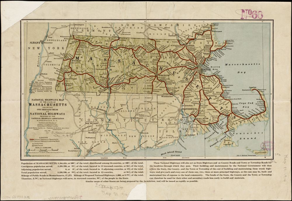
With its connections to the auto industry and its fingers in state and local governments, the Association was a straightforward lobbying organization. In this map, however, they've wrapped their agenda in the mantle of patriotism. The map itself is fairly generic, with a simple outline of the United States crisscrossed by highways. The text of the map, however, makes a strongly persuasive argument that road building is intimately linked with preparedness for the war effort. That word—preparedness—appears throughout the labeling, including in two bold red headlines at the top.
This map lists supporters along the left and right edges starting with the Board of National Trustees, and then followed by numerous other organizations (and their members) supporting the cause, including politicians and business leaders. The subtitle appeals to an all-inclusive sentiment: “We are all for it. Some for war! Some for Defense!! Some for peace!!!” A call for action to join the National Highway Association appears in the bottom right corner. A table of “Facts” states the case for the economic and military importance of good roads. And the familiar image of a finger-pointing Uncle Sam drives the point home. This map wants to leave you with the impression that anything other than full-throated support for the highway building campaign would be tantamount to treason.
The proposed network of highways did not come to fruition until decades later, when the modern interstate highway system was developed in the 1950s. Still, the link between road-building and military preparation remained a crucial part of the political case for this infrastructure—the formal name for the federal roads program, even today, is the “National System of Interstate and Defense Highways.”
A Way With Words
The title of a map isn't the only place mapmakers use words. This map is covered with them! Start by looking at the size of the words. What are the largest words, phrases and sentences?
This map shows a plan for a tangled system of highways crisscrossing the United States. The words on this map are just as complex! See if you can count at least five different fonts or typefaces. What words tell you that the mapmaker wants you to feel good about this plan?
But this mapmaker doesn't rely only on words to tell his story. He uses illustrations, photographs, charts of numbers and patriotic colors. What do you think Uncle Sam, representing the United States and pointing his finger at you, wants you to think about this highway plan?
This plan didn't happen exactly as it is shown here, and the United States didn't have a full system of highways until many years later. But this map did its part to try and persuade viewers that supporting the building of highways is something all good Americans should do.
Bibliography
- Weingroff 2017
- Richard F. Weingroff, Good Roads Everywhere: Charles Henry Davis and the National Highways Association, U.S. Department of Transportation (2017). https://www.fhwa.dot.gov/infrastructure/davis.cfm