This final installment in the “Prelude to a Revolution” series examines how maps shaped the political terrains of the early American Republic, in ways we still experience today. Read the second post in the series here. This digital publication was supported by the Leventhal Map & Education Center's Small Grants for Early Career Digital Publications program.
The maps of Lewis Evans
Especially between the 1720s and the 1750s, competing ideals took shape for managing the kinds of resource scarcity that I described in part one and part two of this series. There were the enlightened improvers, like Jared Eliot, who believed that nature and economy could be improved through new technologies to mitigate climatic constraints and inconvenient shortages. And there were the expansionary cornucopians, who saw nature and Native lands as endless repositories for British—and later, American—plunder.1
Cartographer Lewis Evans carried an element of both of these impulses through his work. Part improver, he marked local climatic conditions and day-lengths-by-latitude on his maps' surfaces and margins to allow the maps' users to more ably adapt to the North American continent's varied terrains and challenging climates. Part expansionary cornucopian, he envisioned his maps as technologies of imperial control: portable objects that would enable the British government and the British-American colonists of his time to achieve unfettered dominion over Native American lands and resources like coal and petroleum.
Evans was the first cartographer to mark each of these resources on an American-printed map, and although neither resource would be mined in his lifetime, three of his maps—"A map of the middle British colonies, in America" (1755), "A map of Pensilvania. New-Jersey, New-York, and the three Delaware counties" (1749), and his "Walking Purchase" map (1737)—prepared the way for the mid-Atlantic region's rapid industrialization and transformation in the decades following the American Revolution.
Take a moment to familiarize yourself with the geography of the Middle Colonies on the eve of the American Revolution by exploring Evans' maps below. The maps primarily represent the colonies of Pennsylvania, New Jersey, and New York, and the traditional homelands of Delaware Lenape peoples and the Six Nations of the Haudenosaunee Confederacy, and Evans’ interpretation of the boundaries of colonial treaties and land cessions.
As two of the first maps ever printed in the British Colonies in North America, Evans' 1749 and 1755 maps measured just 19.3 x 24.6 inches. They were a quarter of the size of most maps of North America, but their modest size did not limit their historical significance; without them, the United States would likely look very different today.
During the Revolutionary War, many Continental Army leaders carried versions of Evans' 1755 map in their pockets. The same was true of British and British-American commanders in the French and Indian War. During the earlier war, George Washington carried a copy of Evans' 1755 map to navigate the contested Ohio River Valley, a vast terrain stretching from today's western Pennsylvania through present-day Ohio to eastern Indiana. Evans took care to represent the Ohio River Valley on his 1755 map to enable precisely this type of reconnaissance.2
Evans' 1737 "Walking Purchase" Map
Before Evans produced his influential 1749 and 1755 maps, he cut his teeth drawing up a map that formalized one of the most notorious land frauds in North America: the Walking Purchase.
Click through the map story below to learn more about the Purchase's fraudulent terms and far-reaching consequences.
Like Eliot's clover-planting experiment recounted in the second post in this series, James Logan and the Penn brothers' orchestration of the Walking Purchase emerged as a response to conditions of scarcity.
The Purchase was brokered at a time when Pennsylvania's population was booming. Between 1720 and 1740, the colony's population grew from approximately 30,000 people to nearly 86,000 people. During the 1720s and 1730s, settlers had already begun to migrate into the territory claimed by the fraudulent deal—without permission from Delaware Lenape people.
As Pennsylvania's population grew, the densely-populated city of Philadelphia began to run out of affordable fuelwood. After the severe winter of 1732–1733, the city appointed public wood-corders—municipal laborers who sourced, cut, and certified wood for urban sale—in an attempt to stabilize the city's wood supply.3 When another severe winter struck in 1736–37, the price of fuelwood escalated, and some Philadelphians froze to death.4 Hay supplies were also scarce during the months preceding the Purchase.5
The heavily timbered forests and lush meadows targeted by Logan and the Penn brothers in the 1737 Walking Purchase promised the expanding, populous city a basis for future growth, warmth and relief.
Native-settler division and Indigenous cultural visions
As Pennsylvanians began to further overtake Delaware Lenape peoples' homelands, tensions between Native peoples and settlers escalated in Pennsylvania's borderlands and the Native Inland Sea. During the ensuing French and Indian War (1754–1763)—an imperial rivalry over land and trade in the Ohio River Valley—Delaware Lenape peoples sided with the French, and lost much of their remaining New Jersey and Pennsylvania homelands in the process.6 The Haudenosaunee Confederacy maintained much of their power and autonomy during the war through strategic participation in key battles and negotiations. Ultimately, Great Britain emerged as the victor, their commanders aided amply by the cartographic intelligence embedded in Lewis Evans' 1755 map.
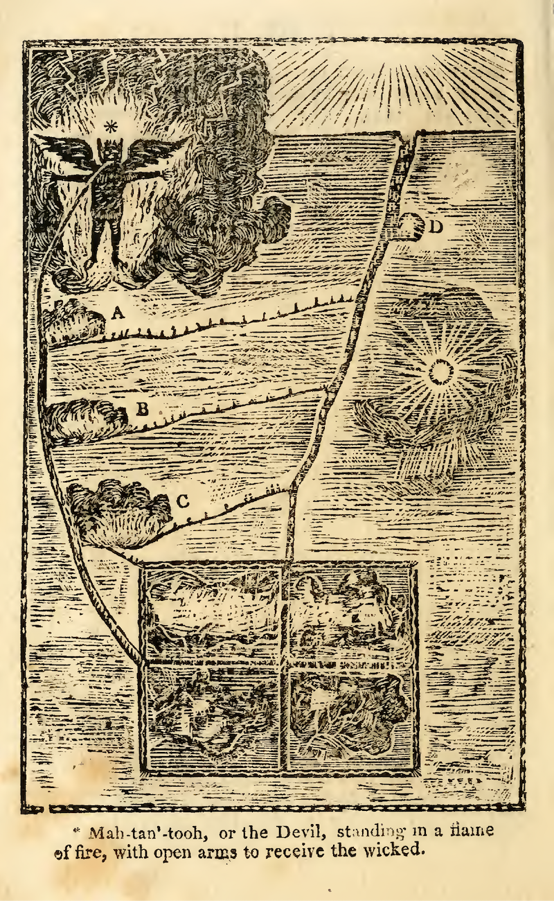
A woodcut of Neolin's "new Plan," reproduced by Pennsylvanian John M'Cullough from memory based on similarly-rendered drawings. From Archibald Loudoun, A Selection of Some of the Most Interesting Narratives of the Outrages Committed by the Indians in Their Wars with the White People (Carlisle, PA: A. Loudon, Printer, 1808), 324.
During this time, Native people began to more widely discuss and defend their own cultural visions of how to live from and govern the land. A Delaware Indian, for example, experienced a revelatory religious vision and changed his name to Neolin (meaning, "The Enlightened) in 1760.
Speaking to his own people and other Native American groups in highly charged sermons in which he was reportedly "almost constantly crying," Neolin implored his fellow Native peoples to give up European products like alcohol and firearms. These, he argued, needed to be replaced by Native-made weapons, tools, and clothing. He urged Native peoples to go back to their old ways, calling for a cultural renaissance. In the 1760s, his "new Plan of religion" began to circulate amongst Native peoples and settlers in printed, pictorial “map” form.7
Shown to the left in a woodcut print, Neolin's allegorical landscape depicts Native people in the foreground of a terrain transformed by the pastures and fields of Europeans settlers. The symbol of a devil (mahtan'tu) looms in the sky, representing wicked temptations and blocking the path between Native people and Neolin's prophecy of cultural revival. A long road stretching toward the horizon suggests an alternate path. Along the way, the landscape's ever-widening European pastures and fields preoccupy the horizon and stand between Neolin's people and Native salvation.8
The Proclamation Line of 1763 Map
Soon after Neolin began preaching spiritual renewal and Indigenous self-determination, Great Britain's King George III issued a proclamation prohibiting colonial settlers from moving westward into Native lands. The proclamation was accompanied by a map—John Gibson's 1763 "Proclamation Line Map"—that effectively reversed the expansionary, cornucopian cartographic project laid out in Lewis Evans' 1755 "A map of the middle British colonies, in America," by demanding that British subjects recognize and respect Indigenous sovereignty and control over the interior of the North American continent.

John Gibson, The British governments in Nth. America (1763)
Stretching from the Gulf of Mexico through the Appalachian Mountains and to the Gulf of St. Lawrence, the line appearing on the 1763 map clarifies that the lands west of this geography are exclusively "LANDS RESERVED for the INDIANS."
By laying this "Proclamation Line," the British Crown aimed to contain its colonial settlements in North America to the Atlantic coast, where it expected its subjects to be not only more governable, but also more profitable. The French and Indian War had been costly. At its close, Great Britain's debt totaled £122.6 million in historical figures—and it stood to climb higher with an annual interest rate of £4.4 million per year.9
In the wake of the War, the line served as a financial instrument. It was also, importantly, a recognition of Native American nations' tribal sovereignty and power.
Beaded Maps: 1764 Council of Niagara Wampum Belts
After an emerging pan-Indian confederacy—the kind urged by Neolin—attacked and seized the majority of Great Britain's forts in the Native Inland Sea following the close of the French and Indian War, in what became known as Pontiac's War, the British Government in North America moved to further recognize Native American nations’ sovereignty and power with a peace council: the 1764 Council of Niagara.
At the Council, British Superintendent of Indian Affairs William Johnson read the Royal Proclamation of 1763 to representatives from twenty-four Native American nations. In an attempt to restore peace in the interior, he also presented each nation with a collection of beaded wampum belts.
The belts were made especially for the peace council. In many ways, they were maps of their own.
The first belt, known as Covenant Chain Wampum Belt, features two figures with their hearts visible, holding hands. The figures represent Great Britain and the Native American nations present at the council. Together, they are attached to a chain of forts and council fires, which represent the geography that Great Britain and the Native American nations agree to peaceably govern.10 The council year also appears on the belt: 1764.
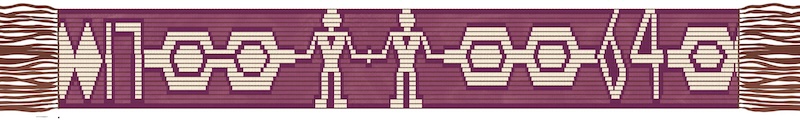
Covenant Chain Wampum Belt, Talking Treaties Collective.
A second wampum belt given by British authorities to each of the Native American nations present at the Council, the 24 Nations Wampum Belt, features a chain of twenty-four figures, hands clasped and hearts showing. The figures represent the twenty-four Native American nations at the 1764 Council. Great Britain is represented in the guise of a ship, and the North American continent is represented in the shape of a mountain plateau.

24 Nations Wampum Belt, Talking Treaties Collective.
The belt's design implies that Native nations will engage in peaceful trade with Great Britain, but only when that trade returns sustenance and life back to Native people and to the North American continent.11 It suggests that British presence in Indigenous Territory is by permission only. The figures representing these nations stand before the continent, as keepers of the land.
The wampum belts exchanged at the 1764 Council of Niagara reaffirmed the terms of earlier treaty agreements between the Dutch and the Haudenosaunee, which were inherited by the British. Those agreements were "mapped" in Two Row Wampum Belts. The rows of this belt represent European and Indigenous nations existing peaceably, each on their own separate row, or path.

Two Row Wampum Belt, 1613 (reproduction by Jacob Ezra Thomas, 1993). Plastic imitation shell and sinew. Woodland Cultural Centre, Brantford, Ontario.
A long line of broken promises
The shape and scope of the United States today clearly indicates how the treaty affirmed at the 1764 Council of Niagara was ultimately broken. The treaty obliged Great Britain to keep colonists from encroaching on Native lands west of the Appalachian Mountain Chain. But colonists quickly began to push past the line, simply considering it an affront to their autonomy and independence.
Continued shortages in forage supplies and fuelwood in highly-settled areas along the Northeastern Atlantic coast likewise compelled many colonists to ignore the boundary set by the 1763 Proclamation Line and the terms of the 1764 Treaty of Niagara, as did conditions of drought.
The 1760s and 1770s period was notably droughty in the New England and the Mid-Atlantic regions. These droughts caused crop failures that further constrained colonists’ forage supplies.
In more ways than one, severe weather and conditions of scarcity in land, hay, and fuelwood pressed upon colonial society in the decades preceding the Revolution.
Much as the industrial powers of the Global North have done in the decades and centuries since, American colonists sought new resource frontiers in response to mounting scarcities in key resources along the Northeastern Atlantic coast, and the severe weather events of their time. Westward expansion into Native American lands became one of the primary means by which colonists aimed to escape these conditions of scarcity and climatic constraint.
Set in dialogue with the much later breach of Paris Agreement signatories' 1.5 °C global heating threshold in 2024, the Proclamation Line map belongs to a transhistorical series of broken promises—first the promise to protect Native American lands from colonial settlement, and later, the promise to protect the Earth's climate from heating beyond a weakly enforced threshold.
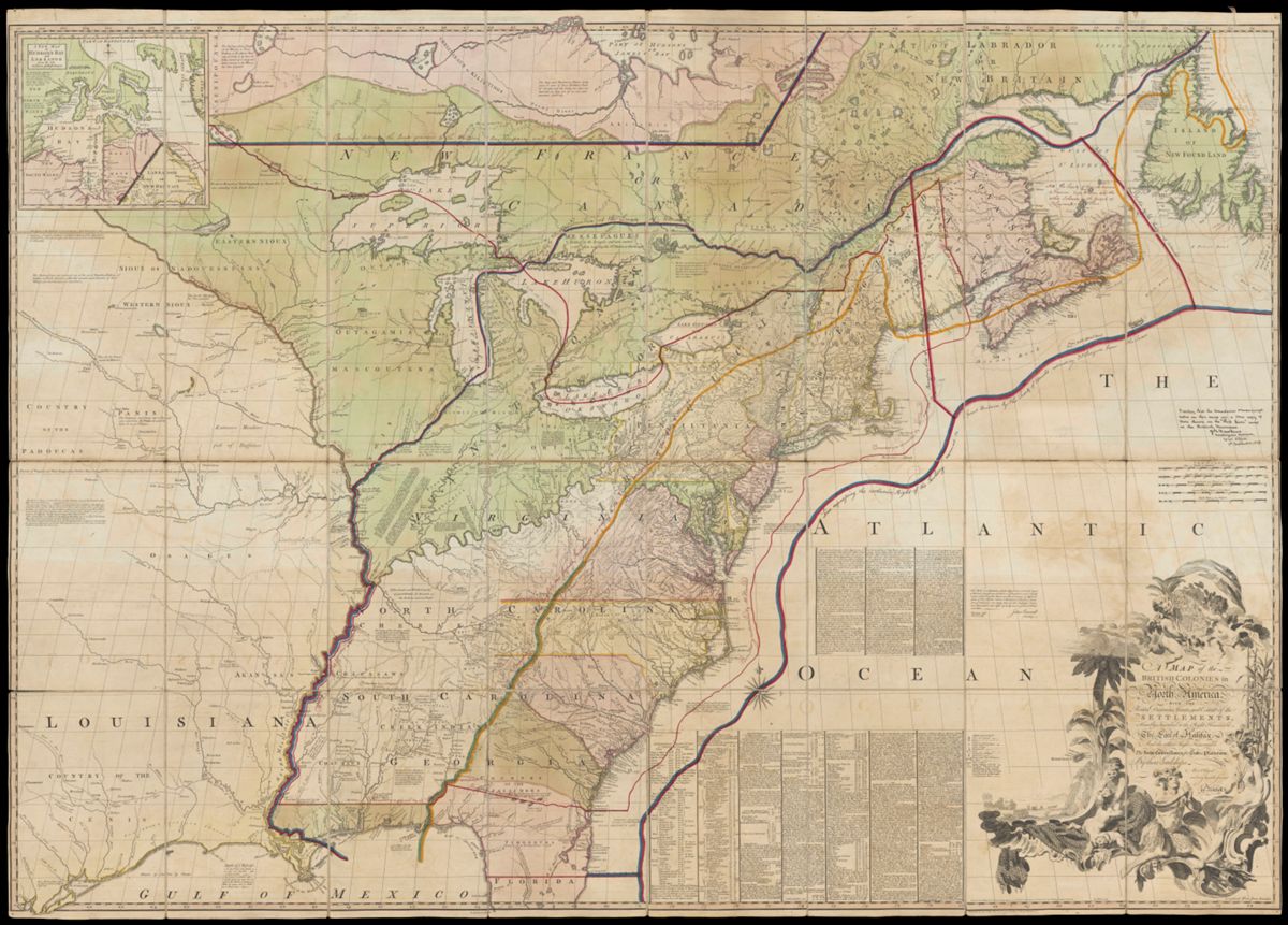
John Mitchell, Map of the British Colonies in North America (1775).
After the Revolutionary War, the land available to white Americans living in the British Crown’s erstwhile colonial project effectively doubled in size as the United States became its own sovereign power. The new nation’s boundaries were set by the 1783 Treaty of Paris. The map above shows the westernmost bound of the newfound United States in a dark red line, ambling up the Mississippi River and through the Great Lakes.
The map, drawn in 1755 by John Mitchell, stands as a reminder of how the trend of setting and then exceeding agreed-upon limits to growth is embedded in the United States’ very DNA. As with the recent Paris Agreement’s attempt to limit greenhouse gas emissions and global temperature rise, limits to the scope of the British colonies’ territorial expanse were established with the Proclamation Line of 1763, and limits to the extent of the United States’ expanse were again articulated in the 1783 Treaty of Paris. In each case, in a matter of several decades, each limit was transgressed: the 1763 Proclamation Line with colonists’ migrations into the interior and with massacres of Native nations during the in 1775–1783 American Revolution; the 1783 Treaty of Paris with the Louisiana Purchase in 1803; and the 2015 Paris Agreement with the breach of the 1.5 °C global heating threshold in 2025.
Preludes and provocations
Over the centuries, people have taken different approaches to coping with the challenges posed by environmental change and climate change. Jared Eliot took the path of enlightened improvement, aiming to technologically resolve the New England and Middle Colonies' forage shortages, soil depletion problems, and climatic extremes with new grasses and better tools. Lewis Evans and John Mitchell, for their part, approached the North American landscape as a canvas for settler-colonial plunder.
The westward-extending lines on Mitchell’s original 1755 map spell out the basis of that vision.

A map of the British and French dominions in North America (1755) by John Mitchell, from the Library of Congress Geography & Map Division
As the composition of the United States’ body politic and physical landscape today reflects, none of the projects advanced by Eliot, Evans, or Mitchell made for a more equal or more democratic republic. Their respective agendas of enlightened improvement and cornucopian expansion held out the promise of wealth, liberty, and affluence for some Americans, and occasioned compromises and concessions for others.
Even Eliot’s approach to enlightened improvement was hardly benign. To solve the problem of scarcity in forage supply in the American colonies, he advocated for the drainage of coastal marshes and swamps—hotspots for biotic diversity and natural sinks for greenhouse gases, like methane and carbon.
For Native Americans, African Americans, women who fought in the Revolution, and a large subset of the United States’ population in the decades and centuries that followed, the revolutionary pledges of liberty, justice, and equality were not equally extended. This is not news, of course, but it is history worth recounting instead of harmfully repeating—particularly as Americans’ 1st, 2nd, and 5th amendment rights continue to be denied in plain view this winter in the media and on American streets.
We have plenty of histories of the United States as a political entity and nation. As America turns 250 on this Semiquincentennial, there is no better time than now to reckon with, analyze, and confront the wide-ranging political, environmental, and climatic consequences of the Industrial and American Revolutions, and act to mend their harms. With all the talk of revolution in this turbulent, contested anniversary year, that, truly, is the revolution we’re still waiting on.
Charlotte Leib is a doctoral candidate in the Department of History at Yale University. Trained in US and early American history, energy history, landscape history, and urban history, Charlotte writes and researches about the cultures, technologies, political economies, and climates that have shaped landscapes and cities in early America and in the nineteenth and twentieth century United States.
Notes
1. Here, I build upon historians Fredrik Albritton Jonsson's and Carl Wennerlind's conceptualizations of "enlightened scarcity" and "cornucopian scarcity" introduced in their book, Scarcity: A History from the Origins of Capitalism to the Climate Crisis (Cambridge, MA: Harvard University Press, 2023): 46–74; 75–102.
2. On these military uses of Evans' 1755 map, see Alexandra L. Montgomery, "Map Talk: Lewis Evans' Map of the Middle British Colonies in North America."
3. Thomas J. Scharf and Thompson Westcott, History of Philadelphia (L.H. Everts & Co, 1884), vol. 1: 206—207.
4. On Philadelphians freezing to death due to fuelwood shortages in 1737, see Scharf and Westcott, 208. On fuelwood prices, see Gary B. Nash, "Up from the Bottom in Franklin's Philadelphia," Past and Present 77 (1977): 57–83 (75, fn. 40). For a more in-depth discussion of Philadelphia's mounting fuelwood shortages see Joyce Chaplin, *The Franklin Stove: An Unintended American Revolution *(New York: Farrar, Straus and Giroux, 2025), 179.
5. On hay swept away in winter floods after snowmelt during the winter of 1737, see The American Weekly Mercury, no. 893, February 8, 1737 (Philadelphia, PA), 3. One observer in Charleston, South Carolina noted that "scarce any" butter had been shipped from New York or Philadelphia to Charleston in 1736–37 year and morality amongst cattle as lessening the butter supply, indicating forage shortages in the Philadelphia area and Middle Colonies. See The South-Carolina Gazette, no. 166, April 2, 1737 (Charleston, SC), 1.
6. A recent addition to this literature, of note, is Ned Blackhawk's account of the French and Indian War in The Rediscovery of America: Native Peoples and the Unmaking of U.S. History (New Haven: Yale University Press, 2023).
7. Here, I draw on Woody Holton's synopsis of Neolin's vision. See Holton, Liberty Is Sweet: The Hidden History of the American Revolution (New York: Simon & Schuster, 2021) 34–36 (fn. 11).
8. Here I draw on my own research and that of Holton (Liberty is Sweet, 35) to interpret the woodcut.
9. Colin G. Calloway, The Scratch of a Pen: 1763 and the Transformation of America (Oxford, England; New York: Oxford University Press, 2006), 12, fn. 35; citing Robert Middlekauff, The Glorious Cause: The American Revolution 1763–1789 (New York: Oxford University Press, 1982), 57.
10. "The 1764 Treaty of Niagara," A Treaty Guide for Torontonians, https://talkingtreaties.ca/treaties-for-torontonians/treaty-of-niagara/1764, accessed November 2, 2025.
11. Ibid.
Our articles are always free
You’ll never hit a paywall or be asked to subscribe to read our free articles. No matter who you are, our articles are free to read—in class, at home, on the train, or wherever you like. In fact, you can even reuse them under a Creative Commons CC BY-ND 2.0 license.