This digital publication was supported by the Leventhal Map & Education Center's Small Grants for Early Career Digital Publications program.
Pierre Duval (1619–1683) was a French producer of maps and atlases. An engraved portrait by Nicolas Langlois depicts Duval at the end of his life as a serious man with a placid expression, a prominent nose, and dull eyes. The portrait is accompanied by a lengthy Latin epitaph that describes him as an inventive spirit, a diligent worker fluent in Latin, and an accomplished cartographer.

Nicolas Langlois, Portrait of Pierre Duval (Paris, after 1683), Archives et Bibliothèque patrimoniale d'Abbeville, 1Fl 8/61
Duval was also the first person in France to publish a series of eight geographic games. Among these is the Tables de géographie réduites en un jeu de cartes (Geographical Tables reduced into a card game), one of the few surviving copies of which is housed in the Leventhal Center collections at the Boston Public Library.
What was the rationale behind the creation of this geographical card game? How did Duval's professional trajectory during the second half of the seventeenth century relate to his broader contributions in recreational geography? And how, exactly, were these games actually played?
Pierre Duval's Eight Geographical Games
Along with his Tables de géographie réduites en un jeu de cartes, Pierre Duval published seven additional geographic games between 1645 and 16741. These games offer a unique lens for examining the new possibilities afforded by print culture as well as the contemporary enthusiasm for social entertainment. His recreational output was diverse, comprising four games of the Goose (jeu de l'oie in French), boards, one checkers-based game, one owl game (jeu de la chouette in French), and two card games.
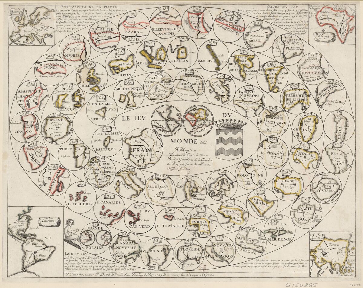
Pierre Duval, Le Jeu du Monde (Paris, 1645), Bibliothèque national de France (hearafter BnF), Department of Prints and Photography, RESERVE QB-201 (38)-FOL p. 62.
In the game of Goose, players race from one square to another based on the roll of dice, aiming to reach the sixty-third square. Characterized by its iconic spiral layout, Goose was among the most popular board games in the seventeenth century. It also represented the principal form in Duval's recreational production, accounting for four out of the eight games he made. Each game is accompanied by texts positioned in the margins, outlining the rules—or Loix du jeu—which regulate player movement.
The Jeu du Monde is composed of the traditional sixty-three squares and offers an overview of the world as it was known to Europeans in 1645, divided into four parts—Europe, Africa, America, and Asia—which are represented in the four corners of the board. A few years later, Duval published two additional games of Goose: one focused on the Kingdom of France (Jeu de France) and the other on Europe (Jeu des princes de l'Europe2).
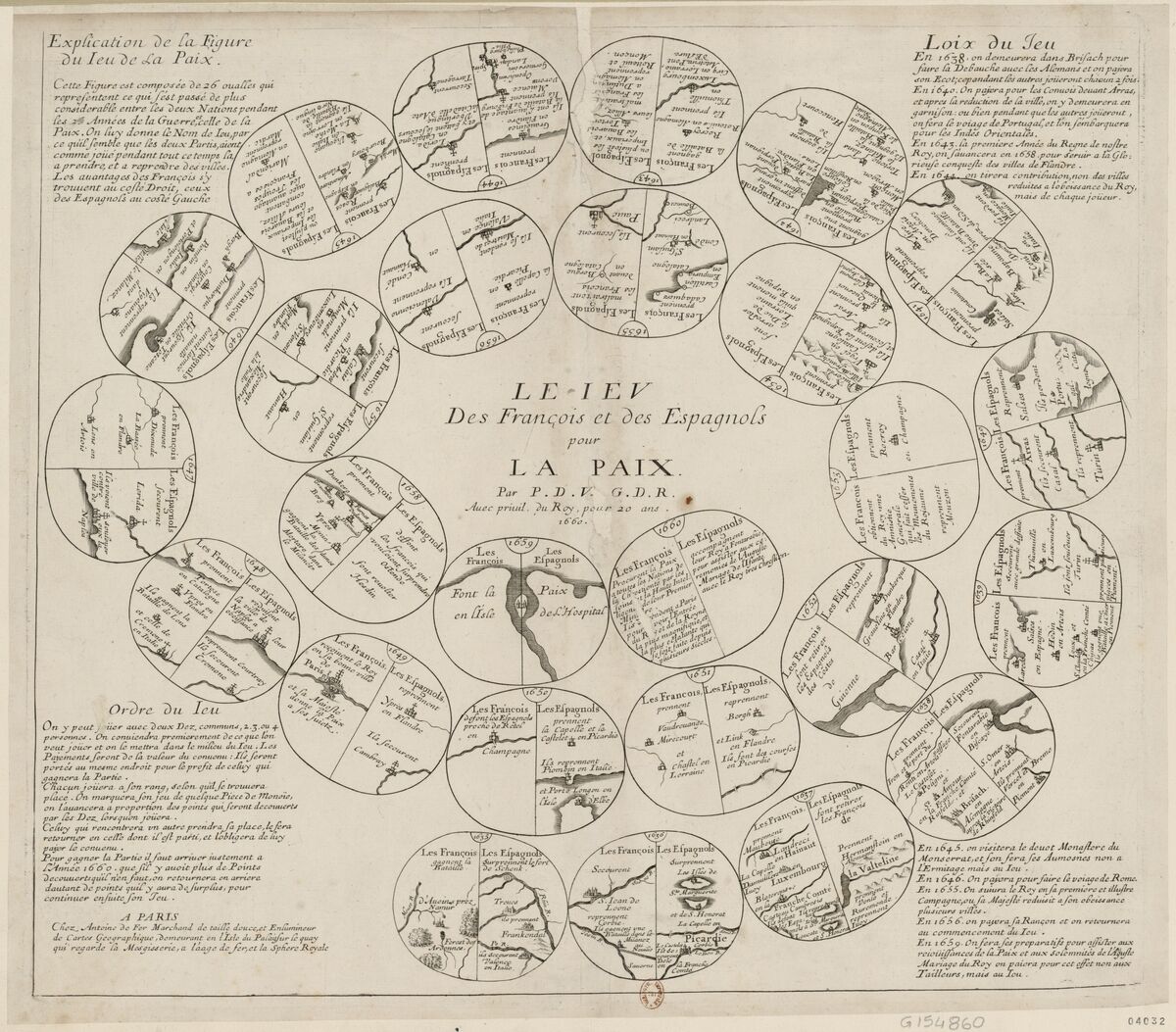
Pierre Duval, Le Jeu des François et des Espagnols pour la Paix (Paris, chez Antoine de Fer,1660), BnF, Department of Prints and Photography, RESERVE QB-201 (45)-FOL, p. 4.
In 1660, he published the Jeu des François et des Espagnols pour la paix, documenting the Franco-Spanish War (1635–59). This game was issued by Antoine de Fer, a merchant of prints and maps and the father of the celebrated Parisian cartographer Nicolas de Fer. This game differs from Duval's earlier ones in two key ways. First, it consists of only twenty-six squares, each divided in two to present the respective advantages of the French and Spanish sides during the conflict. Second, it engages directly with a contemporary political and military event, in contrast to the primarily geographic focus of Duval's previous games.
Duval produced an extensive body of geographical work, including approximately one hundred maps and a dozen atlases. His output spanned both ancient maps in Latin and more contemporary maps of France, Europe, and world geography. A significant portion of his production focused on the political and military developments of his time. The frequent wars waged by the kings of France provided ample opportunities to map battle sites and territorial changes formalized through various peace treaties. One notable example is the richly decorated map of Comté de Bourgogne dit autrement Franche-Comté, published in 1677. A copy held at the Leventhal Center documents the territorial changes following the rapid conquest of Franche-Comté by Louis XIV during the War of Devolution (1667–68).

Pierre Duval, Le Comté de Bourgogne dit autrement Franche-Comté (Paris, 1677), Boston Public Library, Norman B. Leventhal Map & Education Center, G5833.B8 1677 .D88.
Beyond the game of Goose, Pierre Duval created two other geographic games by adapting existing formats: one based on checkers and the other on the owl game. The first, titled Jeu de France pour les Dames (1652), depicts a checkerboard in which each black square is replaced by a map of a French province. The second, Le Jeu des princes souverains d'Europe, is based on the owl game. Played with three dice, it features 56 combinations inscribed within six concentric circles on the print. The number of players is unlimited, with each player receiving an equal number of tokens. The letter "P" indicates a payment due, while the letter "T" signifies a reward. This board game highlights bilateral relations among the various states of Europe.
Finally, Duval also designed two card games: the one discussed in this article and another focusing on the territories of the Holy Roman Empire, published in 1674 under the title Le Jeu des princes de l'Empire d'Allemagne. The Tables de géographie réduites en un jeu de cartes were dedicated to "Monseigneur le Dauphin," the eldest son of Louis XIV. It fits within the broader tradition of educational games established by poet and playwright Jean Desmarets de Saint-Sorlin. In 1644, in collaboration with Florentine engraver Stefano Della Bella, Desmarets produced four emblematic card games: Jeu des fables, Jeu des rois de France, Jeu des reines renommées, and Jeu de la géographie.
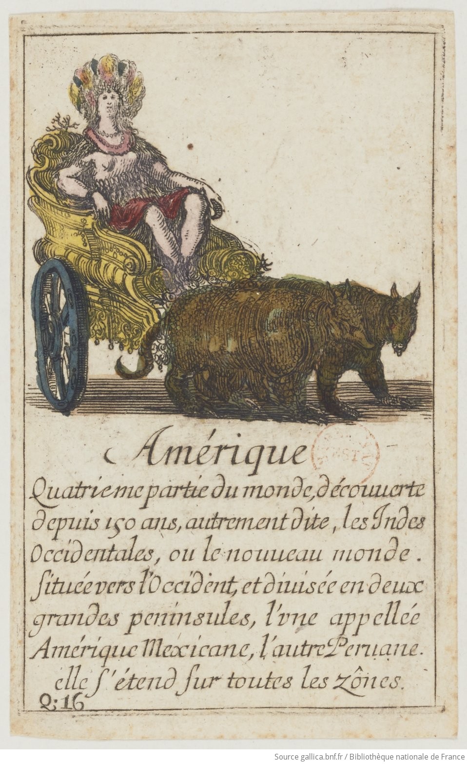
Card of America in Jean Desmarets de Saint-Sorlin, Jeu de la Géographie (Paris, Henry Le Gras, 1644), BnF, Department of Prints and Photography
These games were intended for the education of the young Louis XIV, who was then six years old. Their purpose was to facilitate the study of history, mythology, and geography through play—essential disciplines for a young prince. Jeu de la géographie was one of the earliest card games to mobilize geographic knowledge for educational purposes. Each suit (hearts, spades, diamonds, and clubs) corresponded to a continent (Europe, Asia, Africa, and America). Each card featured a costumed figure, a place name, and a short descriptive text.
For example, within the suit of clubs representing America, the first card depicts an allegorical figure of the continent, followed by twelve cards representing major territories such as Peru, Mexico, New France, Virginia, Florida, Yucatán, Nicaragua, Quivira, Chile, Brazil, Popayán, and the Golden Castile. The card game format thus served as a powerful means of disseminating knowledge—an approach Pierre Duval adopted in his own educational games.
Exploring Duval's games with annotated map stories
The Leventhal Center's Panel Truck tool provides a useful interface for exploring the structure and elements of Duval's games. The first interactive presentation below demonstrates that Les Tables de géographie réduites en un jeu de cartes functions as much as a didactic tool as it does a geographical game. It begins by presenting the game's "identity card"—that is, the key elements required to identify and contextualize it—before exploring the dedication to the Dauphin of France, the eldest son of Louis XIV, and analyzing the four geographic maps and the four aces included in the card game.
The second interactive focuses on the game's internal logic as structured around the honors—kings, queens, and jacks. It seeks to uncover the underlying hierarchy of the game through an analysis of Pierre Duval's selection of specific honors and the portraits associated with them.
A Didactic and Geographic Game Dedicated to the Dauphin
Hierarchy in the Game: The Example of the Honors
Duval’s hierarchical organization of the world according to various criteria was not unique; rather, he echoed popular names and concepts of the seventeenth century. His selections include contemporaneous figures (Moctezuma, Zaga Christ, Elizabeth I), ancient historical figures (Stateira), mythical characters (Pharamond, Rhea Silvia, the Patagonians), literary inventions (Vanlie), imaginary constructs (Candace), and ethnographic types (the jacks). Unlike the kings and queens, the jacks are defined by a relationship of domination, either by their rulers or by Europeans. In sum, the card game reflects the perspective of a European familiar with maritime and colonial explorations; a Parisian publisher, selecting figures resonant in French culture; and a geographer of the King, concerned with the detailed communication of geographical knowledge.
Reflecting on Duval
Duval died in 1683, leaving behind an exceptionally rich body of work consisting of maps, atlases, and games. In March 1684, the Mercure galant—a French periodical dedicated to courtly affairs—published an obituary highlighting that his geographic maps "render his name immortal among the learned."3
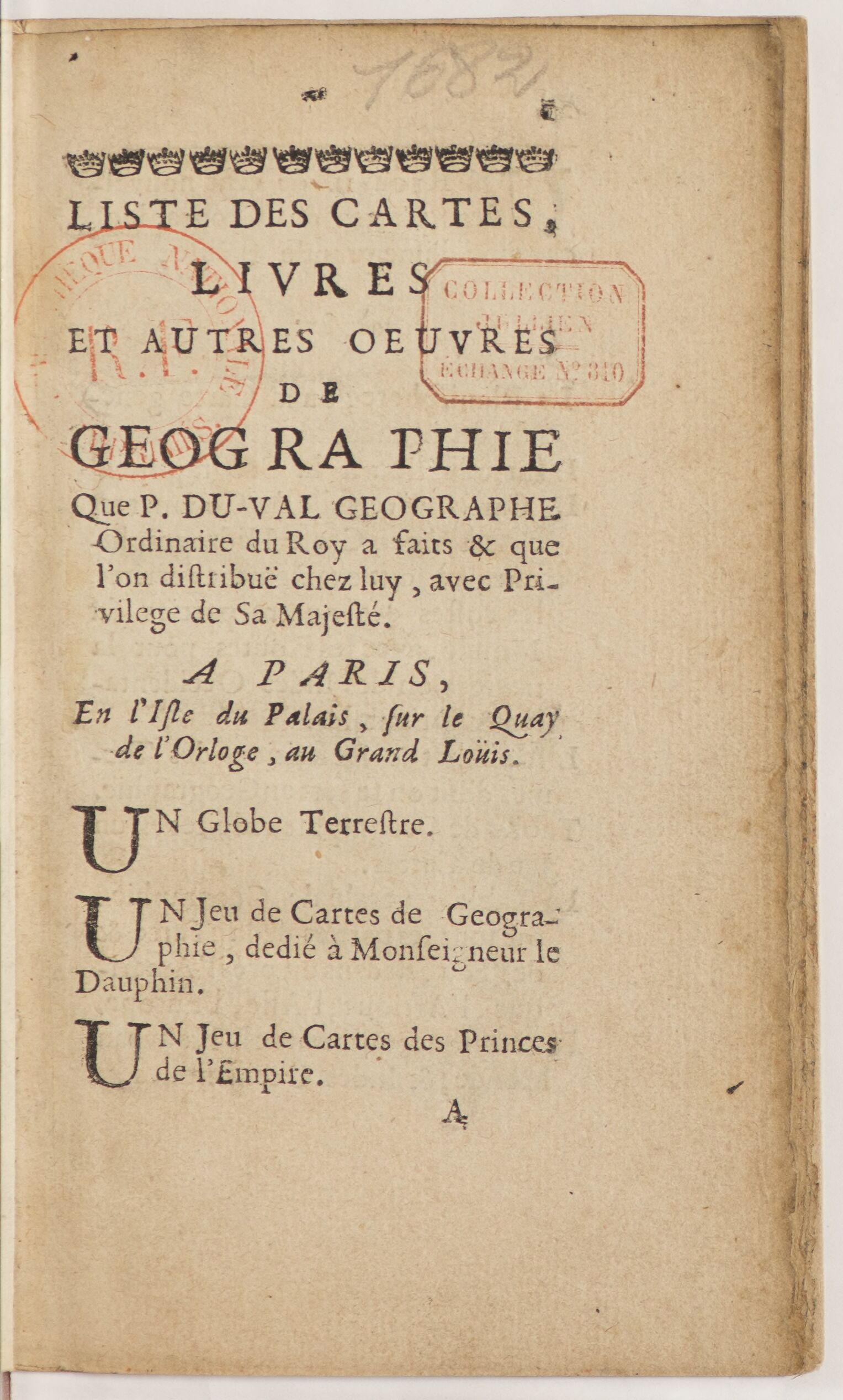
First page of Pierre Duval, Liste des cartes, livres et autres œuvres de géographique (Paris, 1682)
Shortly before his death, in 1682, Duval had published the Liste des cartes, livres et autres œuvres de géographie, a comprehensive catalog of his works. By the seventeenth century, such catalogs had become essential tools for booksellers and publishers, enabling them to organize, present, and promote their publications. As this practice spread among merchants and artisans, geographers and map publishers also adopted it to compile up-to-date inventories of their output, as Duval did. His catalog bears witness to the intense editorial activity of the geographer and the richness of his production of atlases and maps.
However, it is noteworthy that the catalog opens with two card games produced by Duval: the Jeu des Tables de géographie réduites en un jeu de cartes, the subject of this article, and the Jeu des princes de l'Empire d'Allemagne. This prioritization underscores the importance of the playful dimension within the career of the King's Geographer. The card game thus provided an alternative framework for the study of geography, beyond the traditional treatises, manuals, and atlases that were commonly used in Jesuit colleges at the time.

Mademoiselle Duval (daughter of Pierre Duval), Les Tables de Geographie reduites en un jeu de Cartes (Paris, 1688), David Rumsey Map Collection.
Pierre Duval's business was continued by his wife, Marie Desmaretz, and later by one of his daughters, either Marie-Angélique or Michèle. In 1688, one of his daughters reissued the Tables de géographie réduites en un jeu de cartes, modifying only the publisher's address to read: "At Mademoiselle Duval, daughter of the author, on the Quai de l'Horloge near the corner of Rue de Harlay at the sign of the Ancien Buis." The privilege granted to Duval in 1669 for a period of twenty years effectively protected the game from reprinting until nineteen years later. Furthermore, one of Duval's daughters obtained a new privilege on October 2, 1687, granting her the right to "engrave, reprint, sell, and distribute" all of Pierre Duval's works, including his geographical games. Consequently, Duval's playful productions continued to be published by his successors until the early eighteenth century.
Geoffrey Phelippot holds a PhD in History, with a specialization in the History of Science, from the École des hautes études en sciences sociales (EHESS) in Paris. His doctoral dissertation, titled “The Sphère royale: Nicolas de Fer's Cartographic Business in Paris (c.1640–1720),” explores the career of the cartographer Nicolas de Fer and his geographical output through the lens of his shop, known as the Sphère royale.
1. Geoffrey Phelippot, Naissance de la géographie ludique au XVII^e^ siècle: les jeux pédagogiques de Pierre Duval (master's thesis, supervised by Lucien Bély, Paris, Paris-Sorbonne University, 2016).
2. Pierre Duval, Le Jeu des princes de l'Europe (Paris, 1662). Voir Adrian Seville, "The geographical Jeux de l'Oie of Europe", Belgeo, 3-4 |(2008): 427-444. Online: http://journals.openedition.org/belgeo/11907
3. Mercure galant (March 1684, p. 83-84).
Our articles are always free
You’ll never hit a paywall or be asked to subscribe to read our free articles. No matter who you are, our articles are free to read—in class, at home, on the train, or wherever you like. In fact, you can even reuse them under a Creative Commons CC BY-ND 2.0 license.