On March 15, we hosted From The Vault: Bird's Eye View!
From The Vault is a biweekly event series showing collections objects selected by Leventhal Center staff. Panoramic maps, also known as bird’s eye view maps, were a popular cartographic form used primarily by U.S. cities and towns during the late nineteenth and early twentieth centuries. Although not generally drawn to scale like a more “traditional” map, they show street patterns, individual buildings, and major landscape features from a raised perspective - resembling what a bird might see if it was flying over the area.
John Bachmann, Bird's eye view of Boston (1850)
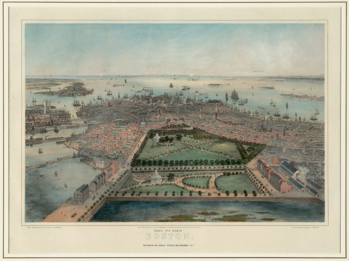
Offering a unique perspective of Boston, this map was created during the very beginnings of the panoramic map “trend”. This map depicts Boston as it was still in the process of backfilling land - the open water at the bottom of the map, oriented to the south of the Public gardens, is now the site of Back Bay, Newbury Street, and the Leventhal Map & Education Center at the Boston Public Library!
Boston and Maine Railroad, Passenger Department, Bird’s Eye View from the Summit of Mt. Washington, New Hampshire (1902)
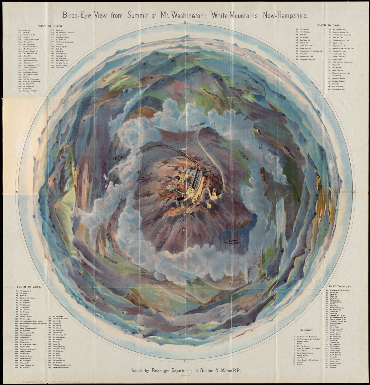
Although entitled a bird’s-eye view, this colorful presentation provides a fish-eye or 360-degree panoramic perspective. It distorts the topography of Mount Washington from a single vantage point directly above the mountain. The mountain’s summit, with accurately delineated buildings and the approaching road and railroad, is the central focus. Everything else is distorted. The surrounding mountains appear in the distance as non-distinctive colored hills, but each is numbered and identified in corresponding lists in the map’s four corners. Published by the Boston and Maine Railroad, this artistic piece would certainly appeal to tourists visiting New England’s tallest landmark.
National Geographic Society, Bird's-eye view of the Panama Canal (1912)
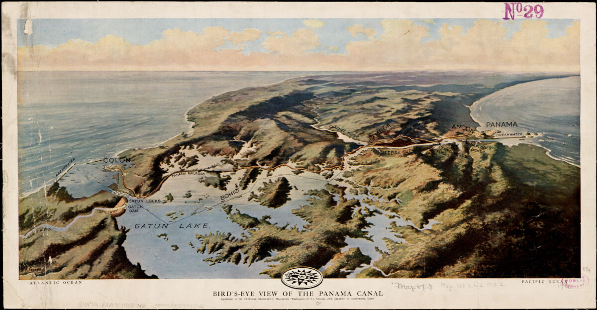
Depicting a spectacular view of the Panama Canal, this map would have been of very high interest at the time. Created by National Geographic in 1912, the Panama Canal was not yet completed (construction finished in 1914). At this point in time, the only other route between the Atlantic and Pacific oceans was to sail around South America or use the Panama Railroad to transfer goods and people from one ocean to another. Both of these options were incredibly time consuming, if not outright treacherous, and many people were eager to see any progress being made on the canal.
Panoramic view of the Gettysburg battlefield (1866)
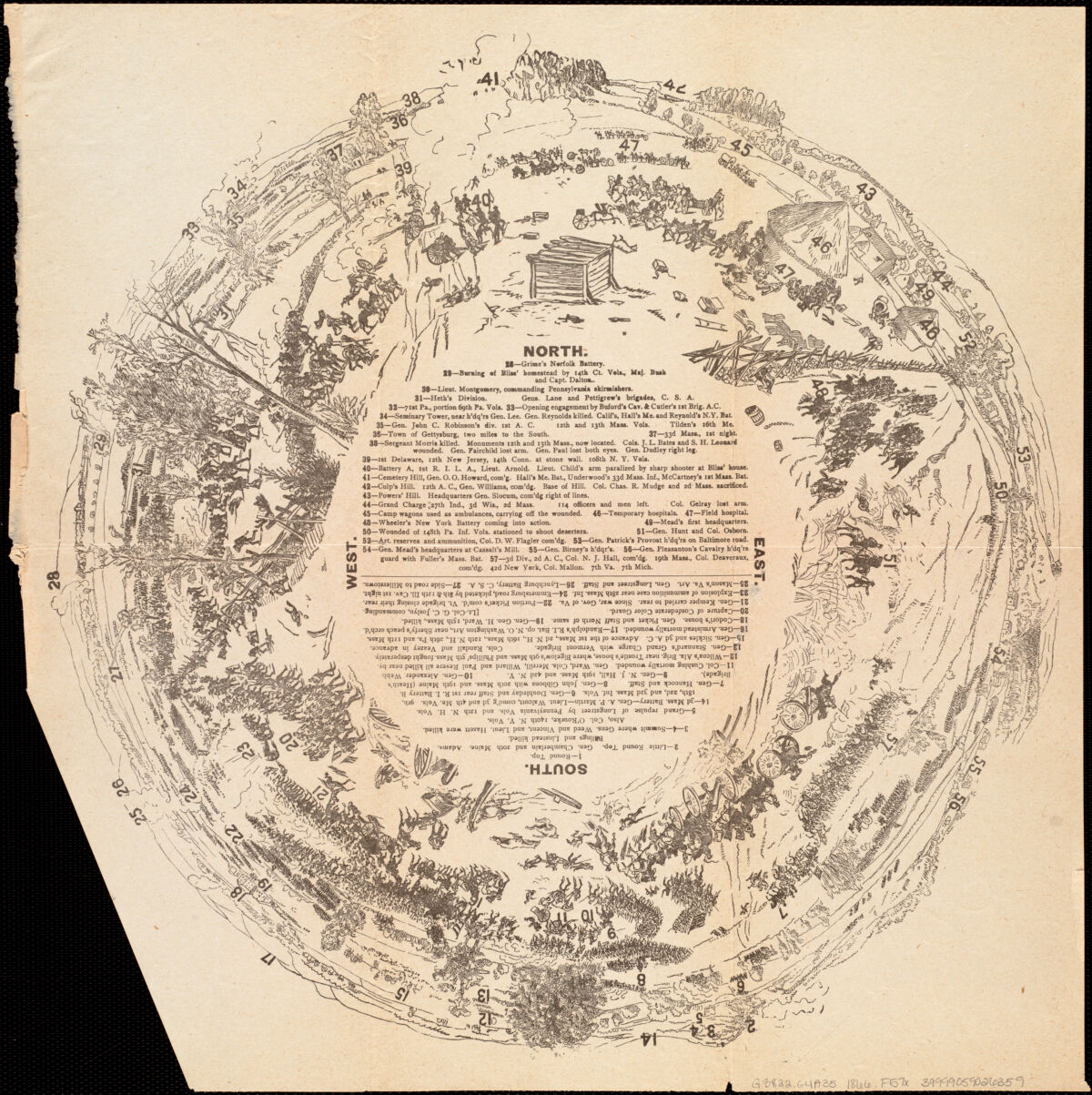
The three-day battle that occurred at Gettysburg, July 1-3, 1863, is considered the turning point of the War. Our memory of the war’s most significant battle is reinforced by approximately 150 maps that have been published in the years following the conflict, far more than any other battle. One of the most unusual is this untitled and undated diagram that provides an unconventional fish-eye or 360-degree panoramic view of the battlefield. In the center of this circular, pictorial diagram is a numbered legend identifying 57 landmarks, locations of specific regiments, or sites of selected casualties.
New York : Harper & Brothers, Pictorial map of the city of Paris and its environs, showing the principal buildings, monuments, parks etc., the French fortifications, and the Prussian lines of investment (1871)
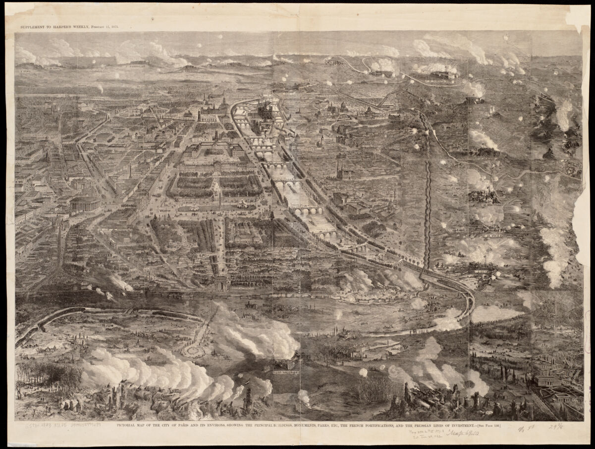
Depicting the Siege of Paris, which took part during the Franco-Prussian War, this map was created shortly after the French surrendered the city. Lead by the Germans, the siege lasted more than four months and cut off from supplies from the countryside, leading the Parisians to eventually begin eating dogs, cats, and even most of the animals in the Paris zoo by the siege’s end. Included in Harper’s Weekly, an American general interest magazine, the American public would have been incredibly interested in seeing what the landscape of Paris looked like during the war.
H. Geissler, Martel's New York Central Park : respectfully dedicated to the park commissioners (1864)

In this birds-eye view of the park, the viewer observes from the junction of 59th St. and 5th Ave. Printed six years after work on the park began, it would undergo another 12 years of construction before its completion in 1876. Its previous location in view, Seneca Village was a middle-class settlement of freed African Americans (the first of its kind in the city) that was forcibly seized by the City of New York in order to create Central Park. Though magnificent in its scope even a third of the way through it’s construction, it’s necessary to remember what it took to build the park and who was mandated to provide it.
Our articles are always free
You’ll never hit a paywall or be asked to subscribe to read our free articles. No matter who you are, our articles are free to read—in class, at home, on the train, or wherever you like. In fact, you can even reuse them under a Creative Commons CC BY-ND 2.0 license.