https://s3.us-east-2.wasabisys.com/lmec-public-files/lmec-main-site-static-assets/articles/ftv-boylston/boylston-on-back-bay.jpegOn October 27, we hosted From The Vault: Past and Future of Boylston Street, together with our colleagues from the Mayor's Office of New Urban Mechanics and the Boston Transportation Department. In this edition of From the Vault, we focused on a street that's near and dear to us at the Boston Public Library: Boylston Street, which is about to be redesigned in order to support multimodal transportation priorities. Boylston Street has changed considerably over time, and this event was an opportunity to look at how the past might inform the present and future of this important urban corridor.
Before Boylston
The three maps in this section all show the location of today's Boylston Street before the modern street was laid out. On each map, the pink outline indicates the later location of Boylston Street from Arlington Street to Massachusetts Avenue.
Boylston Street superimposed atop an excerpt from the 1777 [Pelham map of Revolutionary War-era Boston], before the Back Bay neighborhood was filled
The entire stretch of Boylston Street lies on former salt marshes. During the 1913 Boylston Street subway extension project, workers discovered evidence of fish weirs constructed and maintained 5,200-3,700 YBP (Years Before Present). Indigenous peoples built these wooden traps on the mudflats for harvesting herring between high and low tide, when herring would swim to deeper waters and get caught in the weir in transit.
This 1852 plan represents an early design for the neighborhood that would become the Back Bay, laid out on newly filled land. An ornamental lake would have formed the focal point of the neighborhood. While this plan was ultimately discarded, the idea of gridded streets that would serve in part as recreational amenities and promenades did become a key element of Back Bay’s urban landscape.
This 1860 plan shows Boylston Street about half completed, from Arlington to Exeter Street. The dotted outline of the tidal creek that still wound through Back Bay is visible just at the edge of the fill project, to the west and south of the Boylston-Exeter intersection.
Fuller & Whitney Co., Schedules of land sales (1881–1882)
Back Bay was Boston’s largest single project of land reclamation and real estate speculation. Hundreds of new parcels of property were created on former tidal lands and then sold, and these blueprints document that process. Many élite institutions, such as New Old South Church and the Massachusetts Institute of Technology, located themselves along Boylston Street. In 1895, the Boston Public Library opened the building you are standing in right now, at 700 Boylston Street.
G. M. Hopkins & Co., Atlas of the County of Suffolk, Massachusetts (1874)
This 1874 Hopkins atlas shows where the Boylston St. streetcar line terminated before it was extended to Mass. Ave. in the 1880s. Other atlas publishers did not show streetcar lines on their maps, making this an uncommon snapshot of local transit options.
William T. Oliver, Cyclist's Road Map of Massachusetts (1893)
In the 1890s, when this map was published, bicycles, not automobiles, were seen as the most promising future technology for individual transportation throughout the metropolitan region. In this book of cycling maps covering the entire state of Massachusetts, Boylston St. is one of the bolded lines radiating from downtown Boston.
Richard E. Lufkin, The Central Part of Boston, Massachusetts (Boston Elevated Railway Co.; Walker Lith. & Pub. Co., 1930)
In 1922, BERy added its first bus lines to Boston streets. These early routes replaced less-frequented streetcar lines or extended service to new areas. A rarer approach was taken on busy Boylston St., which as of 1930 hosted a streetcar line, a bus route, and a subway line below. According to this map, few other streets were as multimodal.
Boston Redevelopment Authority, Boylston Street Improvements (ca. 1970s)
In the late 1970s, the BRA added new fixtures to the sidewalks—trees, new paving materials, planters, benches, street lights—as seen in this plan for the block between Mass. Ave. and Hemenway St. Note how the modern globe lights in the plan predate the neo-Victorian street lights on the street today.
WGBH, Ten O'Clock News (May 7, 1982)
While at first the TV cameraperson seems focused on capturing the old Hynes Convention Center, they can’t help but turn their attention to the daredevil roller skater treating Boylston St. as his roller rink. Bicyclists passing through the Mass. Ave. intersection onto Boylston also get their moment in the spotlight.
Boylston in Photographs
Boston Pictorial Archive, Boston Public Library Arts Department
Horsecar tracks were extended westward down Boylston St. from Charles St. to Clarendon St. in the 1870s, and on to Mass. Ave in the 1880s. By 1890, passengers originating in Brookline and Cambridge could reach Boylston St.’s many cultural institutions by electrified streetcars operated by the West End Railway. Designated stopping points were marked with white-painted bands on poles, though it appears the woman hopping on the streetcar in this photograph caught it early while paused in traffic.

Library of Congress, Prints & Photographs Division
The corner of Clarendon and Boylston outside the Hotel Brunswick was a dynamic spot at the turn of the century. Look closely, and you’ll see two hotel guests taking in the sights of horses, pigeons, and a dog interacting with people making their way through the city by foot, bicycle, streetcar, automobile, and horse-drawn carriage.
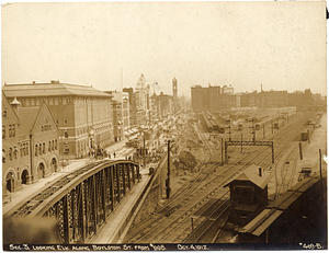
This photograph has it all—subway construction, automobiles, streetcars, horse-drawn wagons, and the Boston & Albany Railyard. It is hard to imagine the noise created by all of this commotion going on at once.
In 1941, the Works Progress Administration and the Highway Division of the City’s Public Works Department removed the streetcar tracks from Boylston St. shortly after the opening of the Huntington Avenue subway.
Boston Herald-Traveler Photo Morgue, Boston Public Library Arts Department
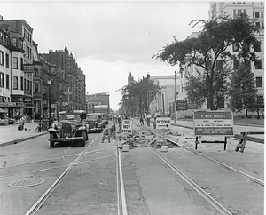
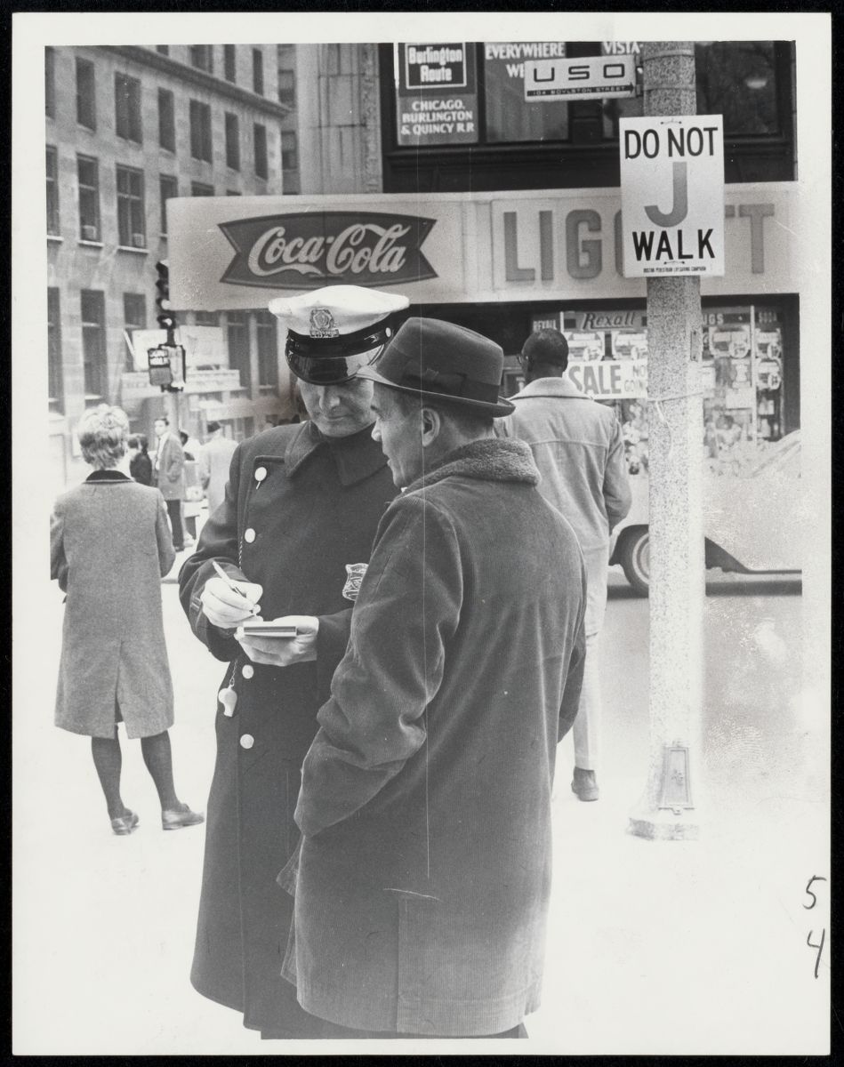
Boylston St.’s current traffic pattern of three eastbound travel lanes and two parking lanes dates to the 1950s. By April 1966, the City’s new anti-jaywalk law reminded pedestrians who the street was meant to serve, though Boston was one of the last major cities in the U.S. to adopt anti-jaywalking regulations. In contrast, note the pedestrians crossing Boylston in the 1906 photo of Hotel Brunswick.
Boston Pictorial Archive, Boston Public Library Arts Department
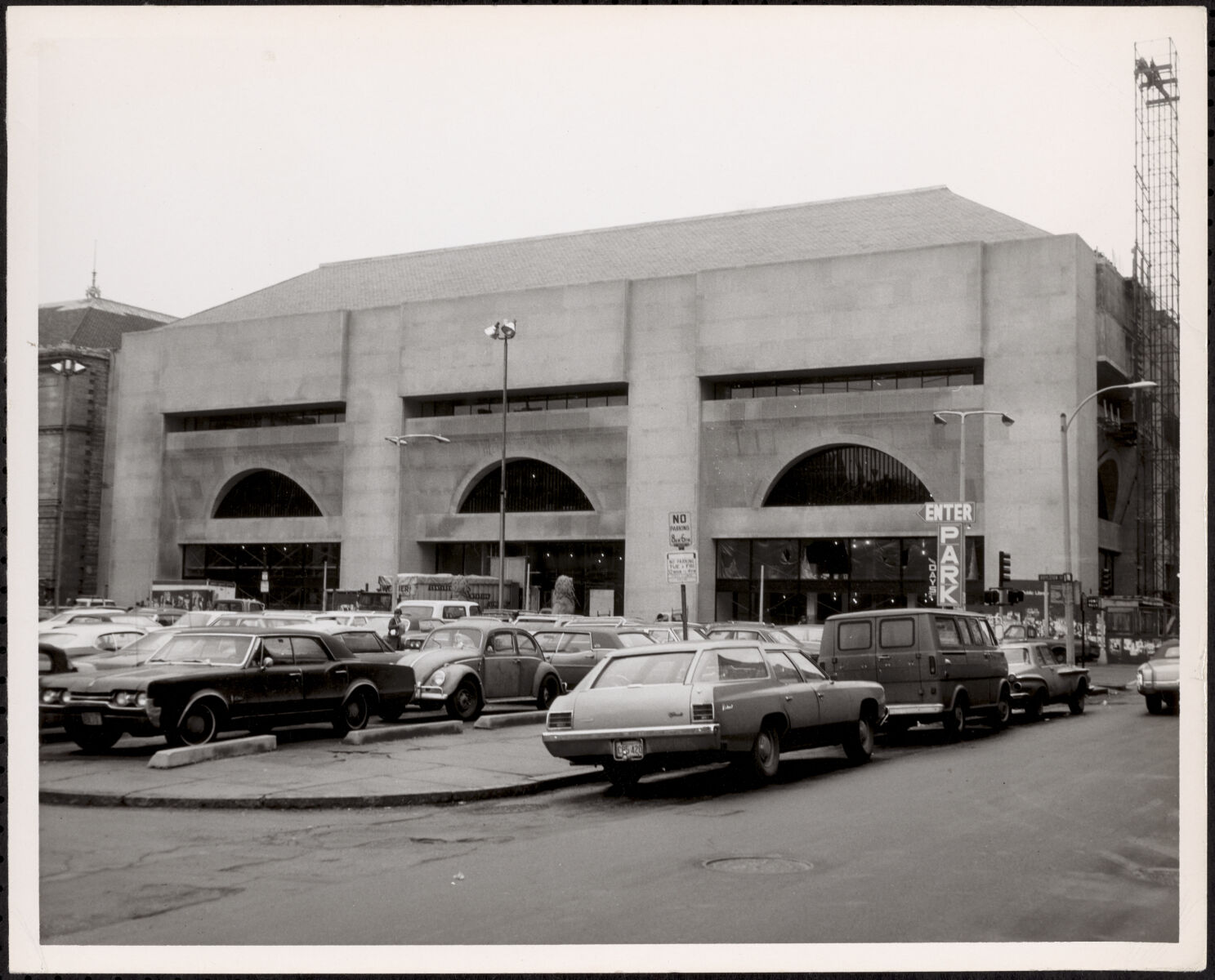
Streetfront parcels were converted to parking lots to serve largely suburban automobile owners driving in to shop and work. This parking lot was created by tearing down former apartments-turned-schoolhouse (the lions that once guarded the building’s entrance are seen guarding the parking lot). At the same time, the new addition to the Boston Public Library recalls how the City was also putting resources toward expanding services to better serve Boston residents.
Our articles are always free
You’ll never hit a paywall or be asked to subscribe to read our free articles. No matter who you are, our articles are free to read—in class, at home, on the train, or wherever you like. In fact, you can even reuse them under a Creative Commons CC BY-ND 2.0 license.