
Looking northeast over Chelsea Creek and Revere in 2019 (Wikimedia Commons user Fletcher, CC-BY-4.0 License)
In June 2022, as school was letting out for summer and nights were getting longer, a relatively obscure headline appeared in a few local papers and industry magazines: a 44-acre oil tank farm along Route 1A in Revere would be sold to a developer and transformed into a “state-of-the-art, technology-enabled warehouse.” The developers proposed, over the course of five years, draining millions of barrels of oil and demolishing 29 storage tanks, and replacing the facility with two warehouses totalling 668,500 square feet.1 The resulting Trident Logistics Center, according to the project’s proponents, would provide “hundreds” of jobs for the area, and significantly contribute to Revere’s tax base. The developer has described the project as an “opportunity to clean up the site” and to “deliver…the highest and best use for the property.”^2
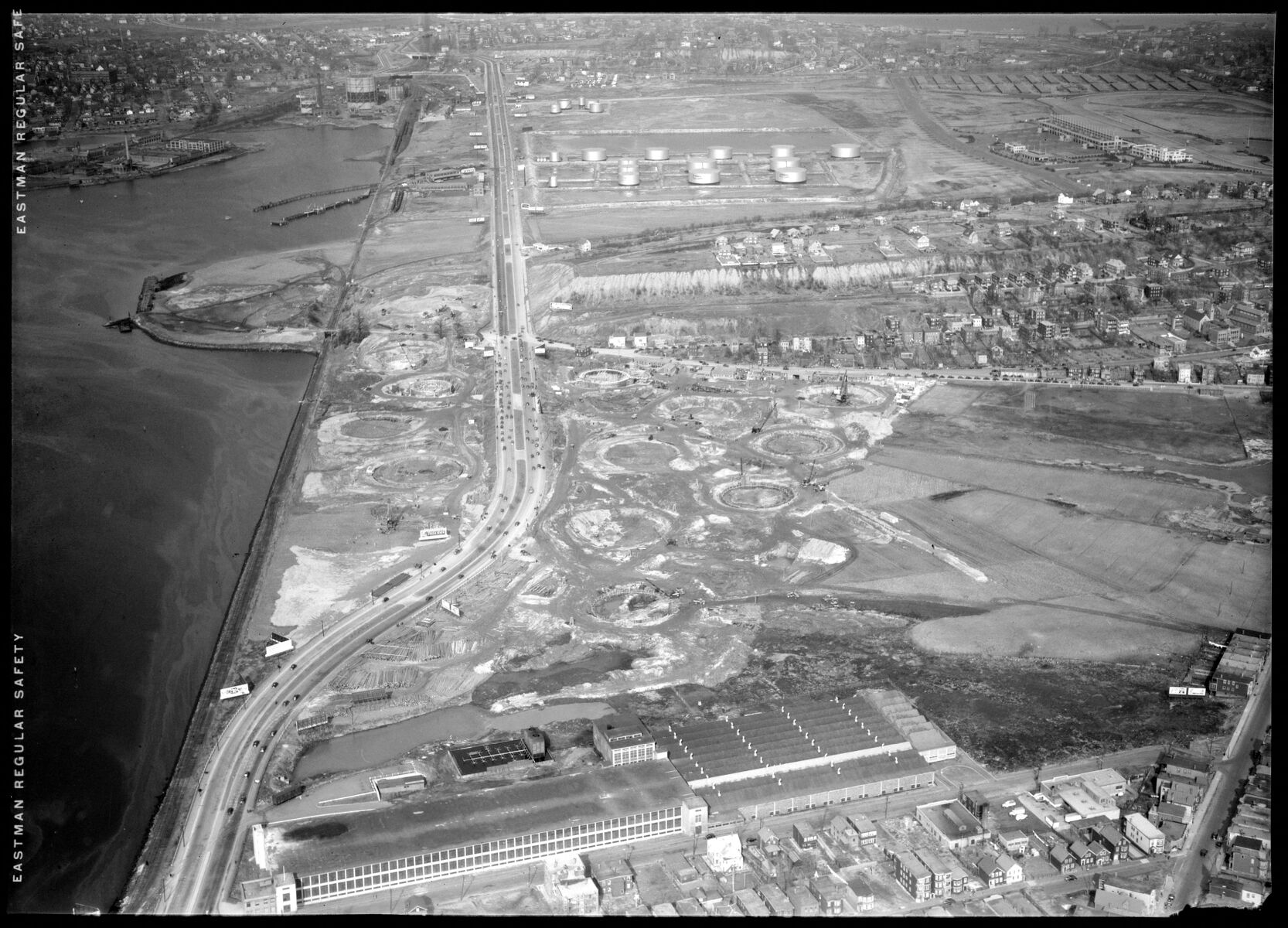
Looking northeast over the oil farm in Revere around 1940 (National Archives Boston)
But the story hardly begins in 2022. For nearly a century, this site has been home to a highly toxic land use. Its soil and groundwater are likely so contaminated that building housing or even commercial buildings would require years of environmental review and remediation. Moreover, the tanks, and the future logistics center, stand on filled marshland: damp, low-lying, and extraordinarily vulnerable to coastal flood and rising sea levels. What else could be built here? And isn’t anything better than oil storage? From this perspective, building a logistics center seems like making the best of a bad situation.
But that sense of inevitability is precisely why “sacrifice zones” like this one have long occupied the social and environmental margins of major cities. 95 years ago, nearly identical language was used to describe the same piece of land—which, in the early twentieth century, was not “land” at all, but a salt marsh bounded by Sales Creek and the upper reaches of Chelsea Creek. A group of developers proposed to improve the wetland by filling it, and topping the fill with the preeminent “center for fuel distribution for Eastern Massachusetts.”4 Their oil farm would be “the outstanding oil storage plant of the United States.”5 What followed was the site we know today: low-slung cylinders that store home heating oil and jet fuel.
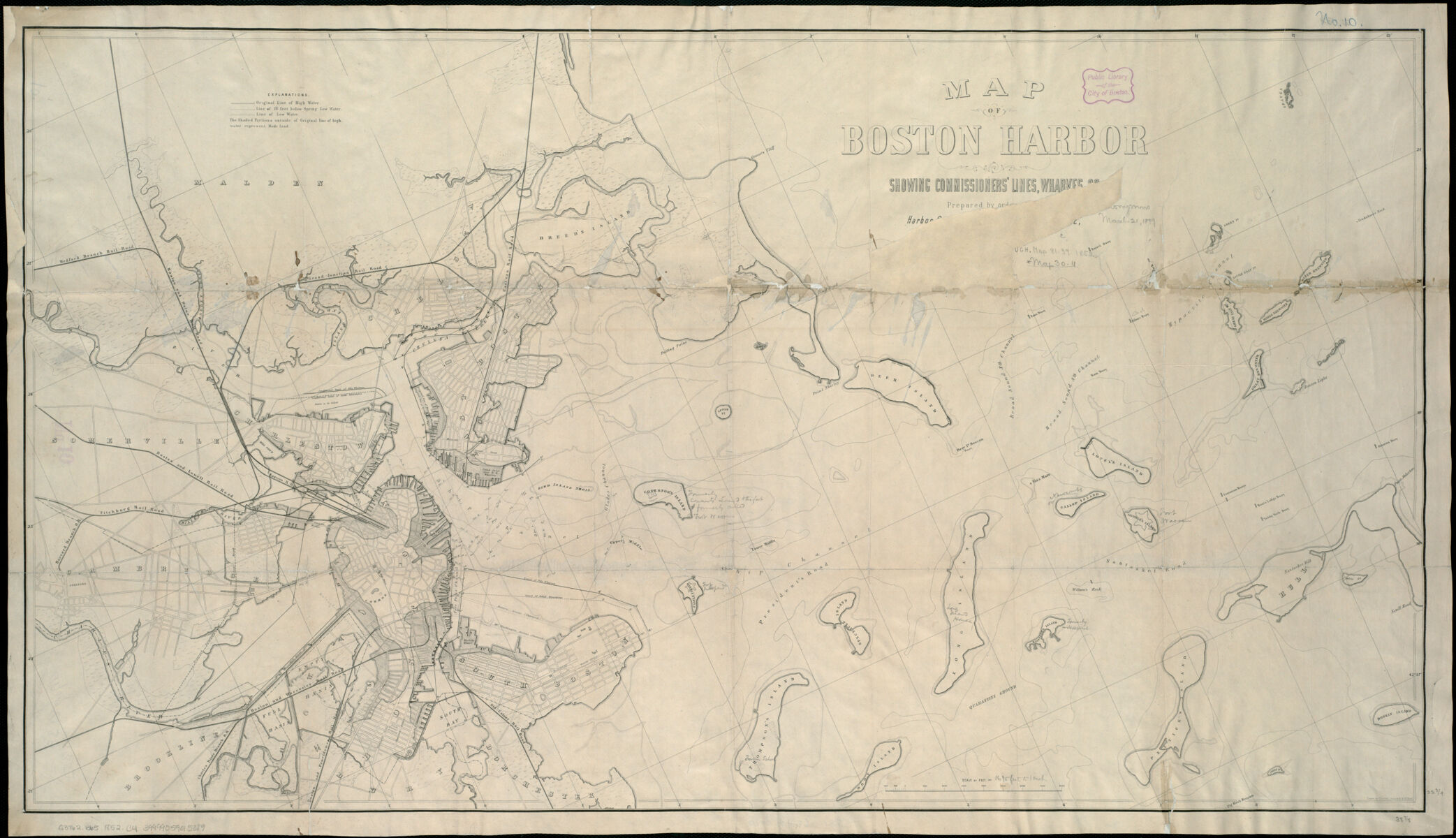
The Harbor Commissioners' map of Boston Harbor from 1852.
The 21st century development of a logistics center, and the echoes of a long-ago justification of a former “highest and best use,” highlight the path dependency of harmful land uses and their attendant infrastructures, which were and continue to be built on sites with little perceived “value” or challenging building conditions. Where once the marsh was marginal and problematic because of its soggy nature, now the oil tank site is marginal and problematic because of decades of pollution.
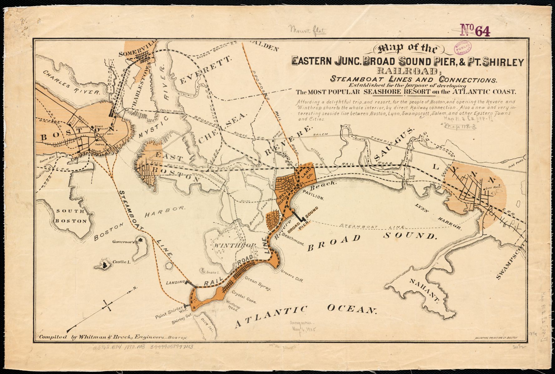
An 1880 map showing coastal destinations and the railroad links to Boston, and the empty space between them
Today we might think of this area in Revere as relatively central, close to downtown, and connected to other parts of the city by road and transit. But in the 1920s, this part of the Boston metropolitan region was the periphery of the growing city. The waterfront resorts of Revere Beach, Point of Pines, and Wonderland had been developed, and train lines had been laid across East Boston and the marshes, but very little had been built alongside the tracks. In maps of Boston and its surrounding towns, the soggy space between Chelsea, East Boston, Winthrop, and Revere was literally and figuratively peripheral, appearing in the corner or off the edge of maps. For instance, an 1891 map of Boston's postal stations showed the area as blank space between East Boston and Winthrop. The landowner of the marsh, when describing the oil farm development, suggested that “the site might be called Land’s End in Revere and might be called an island in Greater Boston, it is so isolated from all.”6
Of course, this obscured the fact that people were already living in these areas. The closest neighborhoods to the marsh, Orient Heights and Beachmont, were home to mostly Italian, Irish, and Eastern European immigrants, and their descendants and families. Many of them worked at the factories in the area, and played in the shallow (and by this time, already contaminated) waters of the creeks and marshes.
Filling in wetlands was common practice throughout the nineteenth century and into the twentieth. Today we know that marshes are not only beautiful but also serve as valuable environmental assets, managing floodwaters and contributing to ecological health. Early twentieth century businesspeople, by contrast, saw marshland as smelly, foul, and unuseful. And in Boston, faced with a booming population and industrial growth, the edges of the city represented prime sites for economic development. The tidal marshlands that lined Boston’s harbor and creeks were filled and developed for a variety of uses, from Back Bay’s elite residential enclave to South Bay’s factories. The many coves and shallows of East Boston had also been filled in over the years, its shorelines made into wharves and piers—straight and knowable and solid.
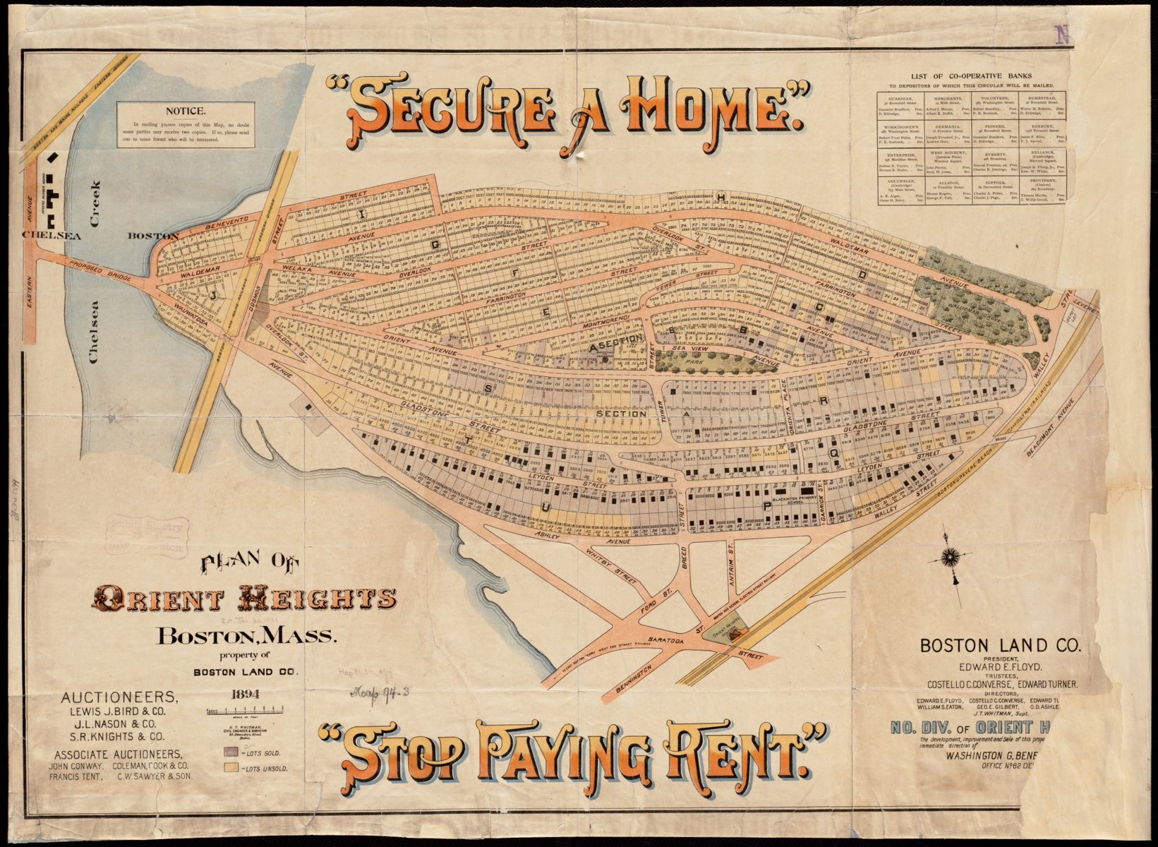
An 1894 map showing the residential subdivision then being built in Orient Heights.
Plans to fill in the marshes between East Boston’s upland, dubbed “Orient Heights” by a developer in the 1890s, and Revere’s Beachmont neighborhood had been proposed as early as the 1880s. Some plans showed this area as a residential enclave, like Back Bay; some a vast industrial area, with wharves stretching into the harbor. But filling a marsh is an expensive undertaking, and neither houses nor wharves would create enough value for developers to recoup any of the development costs, resulting in an uncertain economic calculus for these marginal lands. The marsh would sit unfilled until a more lucrative land use could be proposed to justify the capital costs of reclamation. This land use, it would turn out, was oil storage.
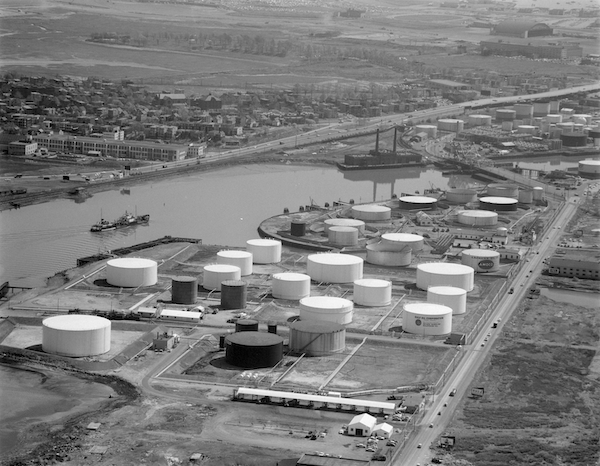
Oil tanks line the shores of Chelsea and East Boston in 1960. The Revere oil facility is just out of the photo to the left, further up Chelsea Creek.
The shoreline of Chelsea Creek was, in a certain light, a perfect place to store oil. Besides being a fuel source, petroleum products provided lubrication for the machines in the countless factories that lined both banks of the shallow creek. It would make sense to locate a vital industrial commodity close to the industries that used it. With the construction of what would later become Logan Airport in East Boston in 1924, this logic grew only more compelling. The airport would need a convenient and nearby place to store jet fuel, and the tidal marsh in Revere fit that bill. Plus, the city of Revere stood to benefit from the development. The tax rates of Boston’s outer-lying suburbs were notoriously high and unpredictable.8 Commenters at the time said that the oil facility would “relieve somewhat the present tax situation in Revere,” adding an estimated $6 million to the land valuation of the city—14% of the city’s total with one development alone.9
With these financial and spatial arguments, oil storage seemed almost like a predestined land use for the marsh. The landowner framed it as such at a public hearing in October, 1927, when he said that “the oil site is located at the southerly tip of the city of Revere in a section now devoted to heavy industry and by its geographical makeup will always be devoted to such industry.”10
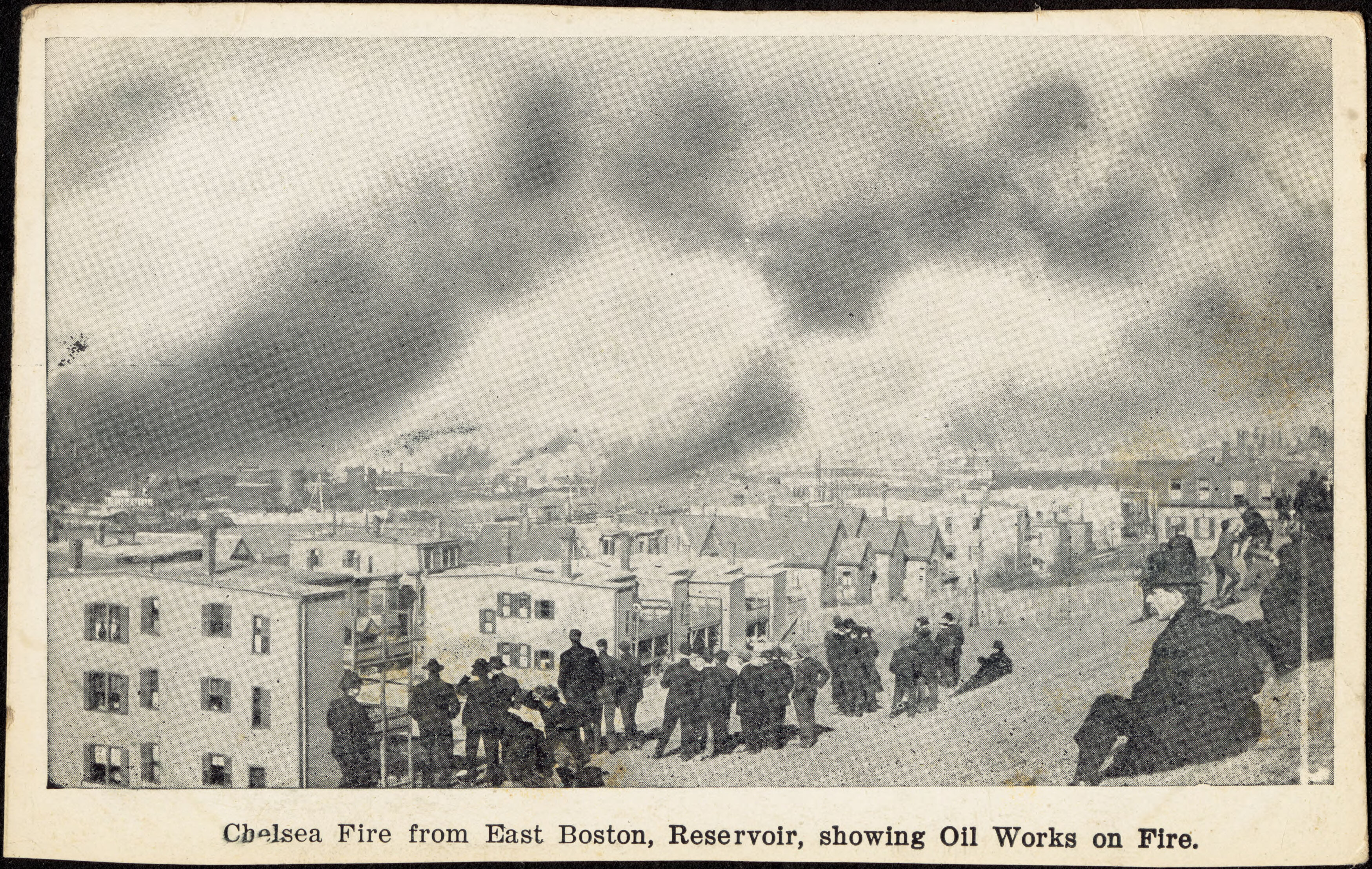
The Great Chelsea Fire of 1908 claimed 23 oil tanks.
But contrary to this conveniently profitable rationalization, oil storage was not a “natural,” healthy, or predestined land use for this area. Not only would it require permanent changes to the landscape—like 25-foot high dikes and constant dredging of the shallow creek—but it also had already proved to be noxious and problematic.11 In 1908, a huge fire erupted at the Standard Oil tanks just south of Orient Heights, destroying homes and property of nearby residences.
What’s most chilling about the landowner’s deterministic language, though, is that it turned out to be self-fulfilling. The statement created the reality it claimed to describe. It wasn’t the geographical makeup that ensured that this land would “always be devoted to such industry,” but rather the social and economic interest that demarcated this marginal and soggy land as low-value and unusable that condemned it to a status as a sacrifice zone. That’s in part what is so pernicious about sacrifice zones: they’re brought into being by the very gaze that views them as sacrificial, allowing the establishment of harmful industries that reinforce the initial definition. These cyclically degraded landscapes are often next door to communities that have also been deemed other or lesser-than, entrenching systems of injustice in the landscape.12 The new logistics center, then, isn’t a better or worse use than oil storage; it is not new, or forward-facing; it is simply the newest pernicious land use, the “highest and best use,” the oil storage of our one-day-delivery era.
Almost a century after the marshlands became an oil storage facility, global demand for oil is climbing ever higher. More planes, more cars, and more ships require fuel to travel locally and around the world; more houses means more need for heating oil to stay warm in winter. But because of declining transportation costs, the economics of proximity that rationalized the placement of oil storage in urban centers, close to the industries that used it, no longer holds. It now makes more financial sense to store oil outside of cities.
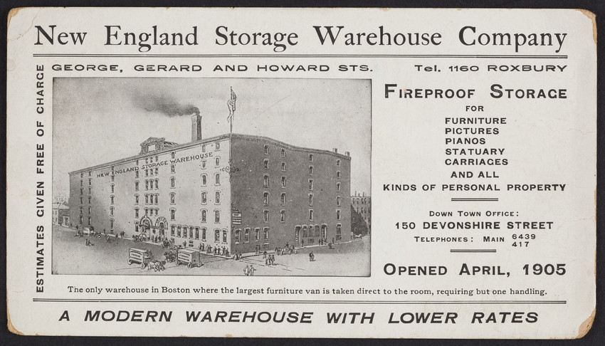
Warehouses are not new to the city; This postcard from 1905 advertises the New England Storage Warehouse Company in Roxbury.
The new darling of the urban industrial real estate market is logistics. All over the country, online shopping trends have driven a spike in demand for warehouses and logistics centers. Where storage facilities used to be the “ugly duckling” of the real estate market, now they represent a fast-growing and lucrative subsector, largely thanks to urban consumers' impatient desire for ever-faster and ever-cheaper shipping costs. Suburban office parks have been converted to warehouses; gargantuan logistics centers now line the farm roads of formerly rural areas.
Pressures have grown especially strong in and around dense urban areas in the pandemic years as more and more people turned to and relied heavily on online ordering and delivery for basic goods. Apps promising 15-minute grocery delivery have snapped up center-city retail spaces that were hollowed out by pandemic closures. Investment has poured into facilities to meet the need for so-called last-mile space, where orders placed online are repackaged and loaded onto trucks for local delivery to our doorsteps.13 In Boston, one consequence of that demand is the planned Trident Logistics Center—no longer delivering fuel into the city, but rather a new kind of consumer commodity.
The terminology here is important. While logistics centers resemble their cousin, the warehouse, they are a considerably different land use with radically different impacts to the environment and neighborhoods. Both of these land uses are shaped by the need for storage, which theorist Clare Lyster defines as the “collection and shelving of items in designated places where they accumulate until needed.”14 This is a foundational human activity that allowed our ancestors to survive the winter; it is also the thing you might do with leftovers, old concert tickets, or photos. Storage, though, is distinct from warehousing, which historian Dara Orenstein distinguishes from simple storage as not just stockpiling for future use, but for profit on that future use.15 Warehouses sprung up in urban centers to manage the flow of the surplus of harvest, ever-greater thanks to railroads and farming machines, and of manufactured goods, and were designed to store these goods as they made their way from the field and factory to retailers.
The physical nature of how the goods were stored and distributed in warehouses is important here: boxes of goods stacked on pallets would be shipped en masse and then be delivered in that same bundle to the retailers, who would unpack the goods. By combining freight shipments and consolidating destinations, delivery trucks could operate more efficiently, coming and going at pre-set hours. By contrast, logistics centers deliver goods from the manufacturer or from a retailer to the consumer. This means that goods are no longer packaged, shipped, and delivered as efficiently-packed freight, but rather as individual items, packed in individual boxes, with just-in-time orders coupled to delivery times expected at breakneck speeds to individual addresses. While storage has always been defined by a flow of goods, and of money, the flow through a logistics center is far faster and more granular.^16
Because the flow of goods is faster through these facilities, the flow of truck traffic is, too. Idling trucks let off diesel exhaust into the air, worsening air pollution, while the hum of their engines contributes to noise pollution. And our restless demand for goods means these trucks come and go at all hours of the night. In Red Hook, Brooklyn, a neighborhood of many Black and Latinx families, a staggering 10% of the total land area is now zoned for logistic centers.17 The neighborhood has a long history of manufacturing, but logistics centers could be worse than factories, because of their oddly hollow qualities: these are spaces that are “technically occupied, but functionally empty,” eroding the vitality of a neighborhood, while concurrently polluting it with fumes and the rattle of engines.18
Logistics centers do indeed create jobs, but we only need look into the stories of Amazon employees falling ill or dying on the job to see how brutal the work is. Not only is it physically taxing, but logistics centers also typically lower pay than manufacturing or service-sector jobs. Moreover, these low-wage jobs are often precarious: vulnerable to automation and easily dismissed during periods of corporate belt-tightening. And while the Trident Logistics Center would certainly contribute to the tax revenue of Revere by increasing the rated value of the land, the question remains: how will that value be experienced by the people who live in the city and who work in the center?
Distinct though they are, storage, warehousing, and logistics share one, foundational characteristic. Whether the storage of oil or the distribution of consumer goods, the negative impacts of these land uses only accumulate at the site of the storage, while the positive impacts are distributed broadly. From the early twentieth century, millions of people spread all across New England enjoyed the benefits of an oil facility in Revere, which made it possible to heat homes cheaply, or fly around the world to visit friends and family. Likewise, millions of online shoppers benefit from the convenience of buying lint rollers, glue sticks, and dog food online in a matter of clicks. But only the people who work in or live alongside the facility where the oil is stored or the glue sticks are being repackaged bear the cost of these things being stored. This uneven spatial distribution of cost and benefit is at the core of environmental injustice, and the sacrifice zones along Route 1A are one dramatic manifestation of this pattern.

This modern-day map tracks social vulnerability and unequal risks of climate hazards.
Land uses are not static; this slice of land between Revere and Boston won’t always be home to a logistics center. What could this area be used for next? Is it destined to always be marginalized, degraded with whatever land use some day replaces the logistics center? Even as we criticize the geographic determinism of development rhetoric on this site, it’s easy to be pulled into a cynical inevitability, where cycles of marginalization and degradation are destined to repeat themselves and the logistics center begets whatever noxious use will cater to consumer demand 100 years from now and make the low-value land valuable again.
Oddly, more pessimism—or realism—breaks us out of this cynical cycle. It may well be that in 100 years, this land is not land anymore, but water; not restored to a wetland, but rather inundated by rising seas. Projections show that Boston could see five feet of sea level rise by 2100, sending many low-lying areas, including the logistics center, underwater.
Even as we look to a future where climate disaster is more than likely, looking to the past provides some hope. After that public meeting in 1927, when the owner of the marshland said that this land would always be devoted to industry, the communities from Orient Heights and Beachmont organized a ferocious resistance to the development. They organized so effectively, argued so vehemently, that they delayed the construction of the oil farm in Revere until 1931.20 Their efforts to protect their neighbors and property from environmental hazards were carried on by East Boston residents when Logan Airport expanded, and jet exhaust caused serious health problems in the neighborhood; they’re carried on today by organizations like GreenRoots and AIR Inc. We can stop cycles of marginalization when we refuse to accept the easy argument of inevitability, and start seeing that, far from being predetermined, the use of land is mutable. This land might never be a salt marsh again, teeming with life and critters, but it may well be something else, more exciting and more just than a logistics center. And it starts with a gaze and an assertion that the health of this land should not be sacrificed for the convenience of others.
Tess McCann is an urban planner, designer, and historian. She currently works in landscape architecture and public realm design, and has a deep love of public transit and the history of land use in American cities. She is a contributor to the New York Review of Architecture.
References
1. “State-of-the-Art, Technology-Enabled Warehouse Proposed for Global Petroleum Site on Route 1A,” Revere Journal, 29 June 2022, https://reverejournal.com/2022/06/29/state-of-the-art-technology-enabled-warehouse-proposed-for-global-petroleum-site-on-route-1a/, accessed 4 August 2022.
3. George Washington Bromley and Walter Scott Bromley, Atlas of the City of Chelsea and the Towns of Revere and Winthrop, Plate N (Philadelphia: G.W. Bromley & Co., 1886), Norman B. Leventhal Map & Education Center, https://collections.leventhalmap.org/search/commonwealth:tt44pv47z. Whitman & Howard, Atlas of the Towns of Revere and Winthrop, Suffolk County, Massachusetts. Sheet 7 (Whitman & Howard, 1906), Norman B. Leventhal Map & Education Center, https://collections.leventhalmap.org/search/commonwealth:9g54z2270. Bromley and Bromley, “Atlas of the City of Chelsea and the Towns of Revere & Winthrop, Massachusetts : Plate 17.” George Washington Bromley and Walter Scott Bromley, Atlas of the City of Chelsea and the Towns of Revere & Winthrop, Massachusetts : Plate 17 (Philadelphia: G.W. Bromley & Co., 1914), Norman B. Leventhal Map & Education Center, https://collections.leventhalmap.org/search/commonwealth:tt44pw696.
4. “More Revere Folk Uphold Oil ‘Farm,’” The Boston Globe, 18 October 1927.
5. “Audience Against Oil Storage Plant,” The Boston Globe, 12 May 1931. “First Work is Done on Revere Oil Farm,” The Boston Globe, 19 November 1931.
6. Ibid, emphasis added.
7. Garrett Dash Nelson, editor and curator, et al.,_ More or Less in Common: Environment and Justice in the Human Landscape_ (Leventhal Map & Education Center at the Boston Public Library, 2022). https://www.leventhalmap.org/digital-exhibitions/more-or-less-in-common/topics/managing-nature-people/
8. “Home Seekers are Greatly Interested in the Great Auction Sale at Orient Heights,” The Boston Globe, 27 May 1894. Nelson, “Making the Single City.”
9. “More Revere Folk Uphold Oil ‘Farm,’” “First Work is Done on Revere Oil Farm.”
10. Ibid, emphasis added.
11. “First Work is Done on Revere Oil Farm,” The Boston Globe, 19 November 1931.
12. Garrett Dash Nelson, editor and curator, et al., More or Less in Common: Environment and Justice in the Human Landscape (Leventhal Map & Education Center at the Boston Public Library, 2022). https://www.leventhalmap.org/digital-exhibitions/more-or-less-in-common/
13. Will Parker, “Pandemic Delivery Boom Fuels Demand for ‘Last Mile’ Space,” Wall Street Journal, 29 November 2021, https://www.wsj.com/articles/pandemic-delivery-boom-fuels-demand-for-last-mile-space-11638277201, accessed 4 August 2022.
14. Clare Lyster, “Storage Flows: Logistics as Urban Choreography,” Harvard Design Magazine, 2016, http://www.harvarddesignmagazine.org/issues/43/storage-flowslogistics-as-urban-choreography, accessed 4 August 2022.
15. Dara Orenstein, Out of Stock: The Warehouse in the History of Capitalism (Chicago: The University of Chicago Press, 2019), 35.
17. María Paula Rubiano A., “A ‘Warehouse’ By Any Other Name,” Grist, 25 May 2022, https://grist.org/buildings/a-warehouse-by-any-other-name/, accessed 4 August 2022.
18. Michael Waters, “Online Shopping Is Reshaping Real-World Cities,” WIRED, 22 February 2022, https://www.wired.com/story/dark-stores-ecommerce-cities-urban-planning/, accessed 4 August 2022.
19. Garrett Dash Nelson, editor and curator, et al., More or Less in Common: Environment and Justice in the Human Landscape (Leventhal Map & Education Center at the Boston Public Library, 2022). https://www.leventhalmap.org/digital-exhibitions/more-or-less-in-common/topics/sacrifice-zones/
20. “E. Boston Folk Storm City Hall in Oil Plant Protest,” The Boston Globe, 18 September 1929; “Revere Oil ‘Farm’ Hearings Closed,” The Boston Globe, 25 October 1927; “Two Protest Meetings in Fight on Oil Tank,” The Boston Globe, 8 May 1931; “Audience Against Oil Storage Plant,” The Boston Globe, 12 May 1931.
Our articles are always free
You’ll never hit a paywall or be asked to subscribe to read our free articles. No matter who you are, our articles are free to read—in class, at home, on the train, or wherever you like. In fact, you can even reuse them under a Creative Commons CC BY-ND 2.0 license.