In December, as part of our Cartography Challenges program, we asked you to submit your “transporatation dreams” for Boston. What sorts of new lines would you draw, new maps would you make, and new ideas would you imagine?
We were overwhelmed us with the ambitious, creative, and thoughtful responses to the prompt of depicting a speculative transit system of the greater Boston area. As much as we loved everyone’s submissions, there were two that rose to the top.
The people’s choice award
For two weeks in February, we posted all of the submissions to this Challenge in front of the Leventhal Center’s entrance. Patrons were invited to examine the maps—along with the technical statements that described the cartographers' methods and considerations—before casting a vote for their favorite.
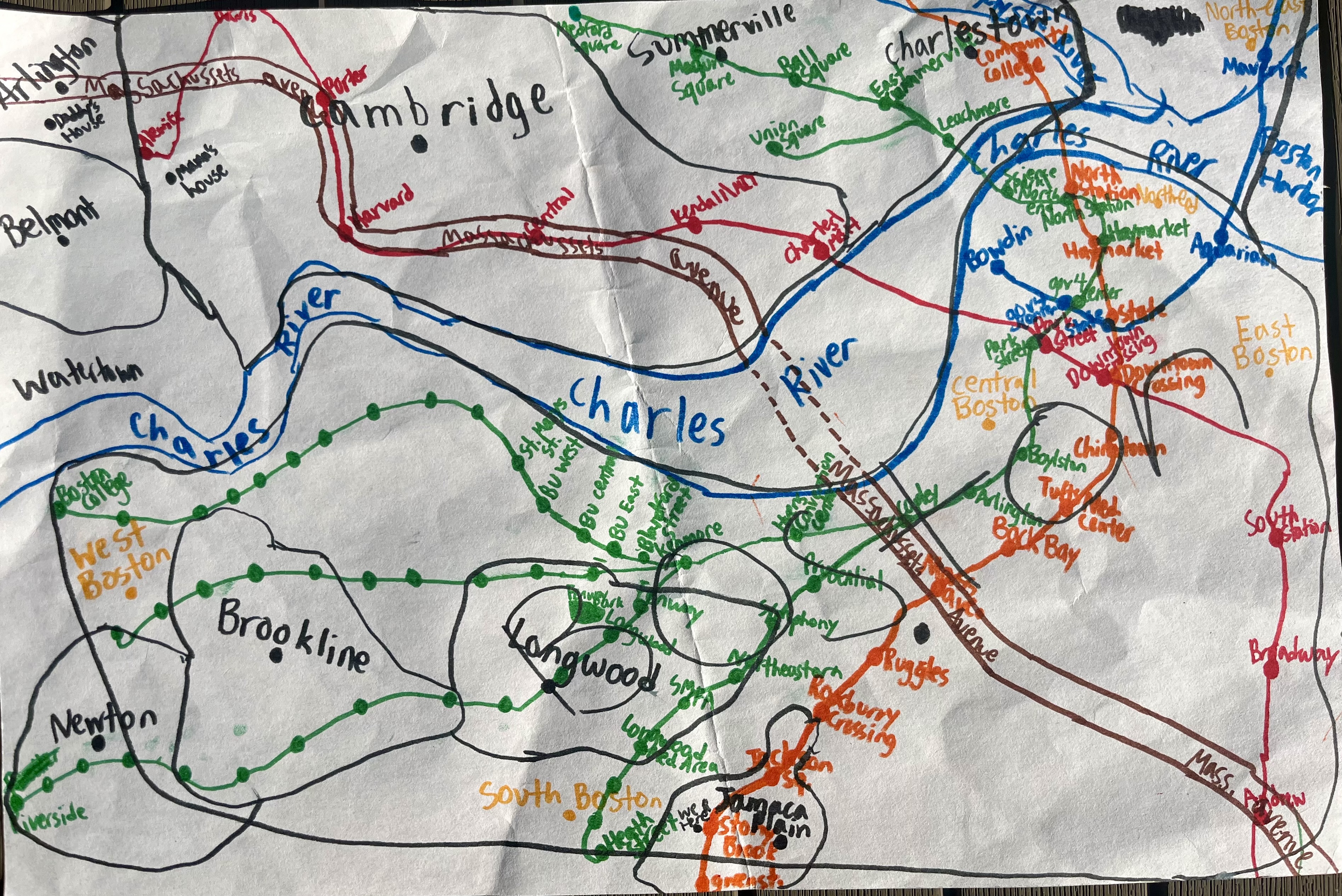
In a decisive victory, eleven-year-old Alessandro Navarro Gatti took home the people’s choice award. Alessandro has been drawing maps of Boston and Cambridge every day since the age of four, a practice that he continues every day, evidenced by numerous notebooks and sketch pads full of hand drawn maps. His winning submission includes numerous features of interest, including the main thoroughfare of Massachusetts Avenue, the Charles River, city boundaries, and of course, the lines of the T. Having fallen in love with the MBTA as a toddler, Alessandro is now an avid rider of the system, and finds it soothing to draw maps of the system.

Alessandro's map, drawn from memory, of the MBTA.
According to his technical statement, his workflow consists of drawing maps of the MBTA—and Boston/Cambridge—from memory on his 25" x 30" sketchpad with markers.
Alessandro will be conferred a $50 prize for winning the people’s choice award. Congratulations, Alessandro!
The judges' choice award
In addition to the people’s vote, we invited a panel of guest judges—Matthew J. Keifer, Esq. (real estate attorney and member of the Leventhal Center’s Board of Review), Sylvia Welsh (20+ years of experience working with maps and plans as as professional archivist), and Katie Calandriello (Policy Analyst & Program Manager, TransitMatters)—to evaluate all the “transportation dreams” submissions according to a shared rubric.
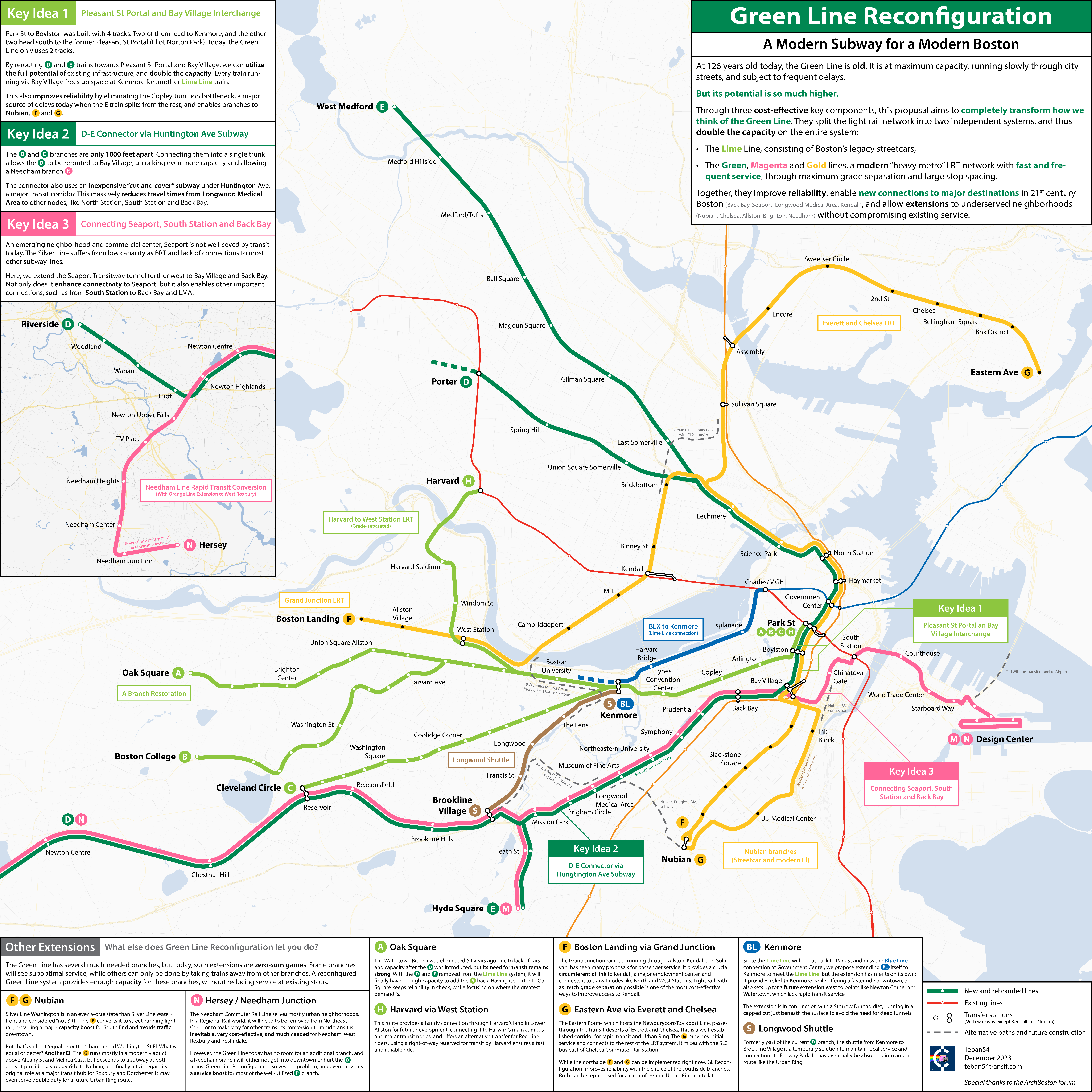
For the judges, Charles Lyu’s map “Green Line Reconfiguration: A Modern Subway for a Modern Boston” stood out among the excellent transportation dreams that applicants to the challenge proposed.

Charles' map of Green Line reconfiguration.
With the detail in his proposals for lime, magenta, and orange lines, Charles' map rises to the challenge of “speculative” maps. The judges agreed that Charles' map expressed a “deeply thought through and clearly stated” logic to propose unique, creative solutions that had meaningful applications for transportation planners.
“Green Line Reconfiguration is a line of proposals that aim to redesign and reimagine Boston’s Light Rail Transit (LRT) system, known solely as the Green Line today,” Charles explained in his technical statement. “Through three cost-effective key components, this concept not only doubles its overall capacity, but also creates a subsystem with faster, more frequent and more reliable service that functions as a metro network, while connecting major destinations in 21st century Boston.”

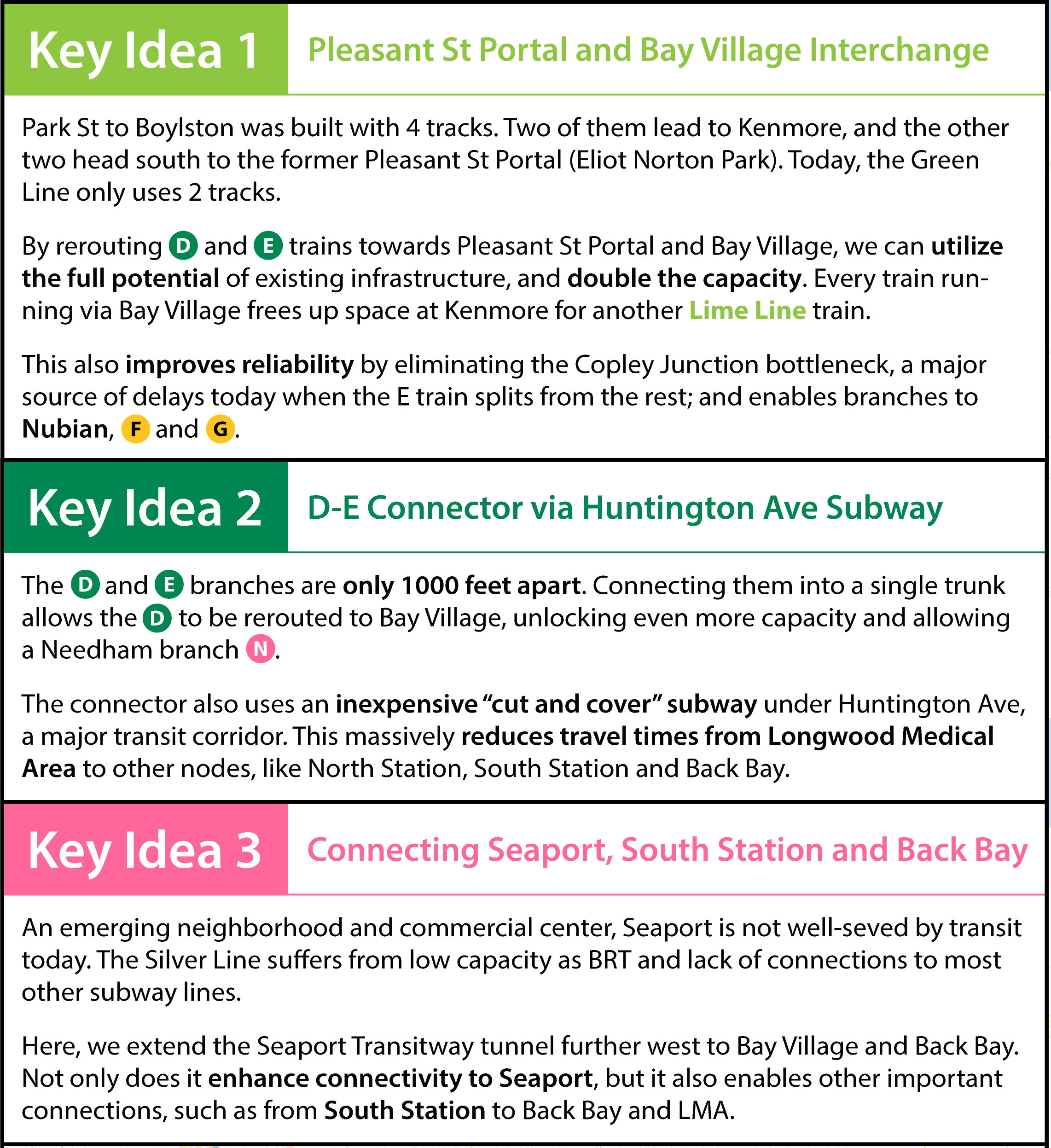
Three key ideas underpinning Charles' proposed Green Line reconfiguration.
Charles first key idea includes rerouting D and E line trains to proposed Pleasant Street Portal and Bay Village stops, with the goal of relieving bottlenecks near Copley and improving overall capacity.
His second key idea hinges on connecting the D and E lines near Brookline Village, including the addition of a cut and cover subway under Huntington Avenue to provide more relief for travel times.
The final key idea is to connect Seaport, South Station, and Back Bay. The Leventhal Center’s exhibition Getting Around Town discusses many “unrealized possibilities” for Boston’s transit system, including a proposal to connect North and South Stations as part of the Big Dig. This never happened, of course, but the proposal included a connection between Back Bay and South Station. To this extent, Charles' proposed connection resolves one of these unrealized possibilities.
These sorts of radical ideas are so often the product of community thinking, and Charles' map is no exception. “This concept was first proposed collectively by the ArchBoston forum, and my map illustrates most of the key ideas,” Charles writes in his technical statement. “I would like to thank many ArchBoston members who made invaluable contributions in more than 10 years. While I participated in many discussions myself, my map would not have been possible without the creativity, analyses and insights of other members, such as Riverside, F-Line to Dudley, vanshnookenraggen, davem, The EGE, Brattle Loop, 737900er, TheRatmeister, and many more.”
In addition to a $250 award, Charles' map will be accessioned into the Leventhal Center’s digital collections.
The Leventhal Center’s Cartography Challenges are posted at least once per year, so keep an eye out for the next prompt. If you have questions about the program, please contact Ian Spangler.
Our articles are always free
You’ll never hit a paywall or be asked to subscribe to read our free articles. No matter who you are, our articles are free to read—in class, at home, on the train, or wherever you like. In fact, you can even reuse them under a Creative Commons CC BY-ND 2.0 license.