The Leventhal Center’s Atlascope tool
In January 2023, when we released an updated version of Atlascope—the Leventhal Center’s digital tool for exploring historic urban atlases—we rolled out new features for creating Atlascope Tours and user-submitted annotations, as well as searching photos on Digital Commonwealth by geographic area. These new features extend Atlascope into a tool that enables users to research, curate, and interpret their own stories.
When we launched Atlascope v2, however, there was a crucial little thing that we did not include: more atlases.
For nearly three years, Atlascope has boasted “101 atlas layers of Boston and its inner suburbs.” While 101 is a great number, it represents only a fraction of the cities and towns that are represented in the Leventhal Center’s vast collection of urban atlases, to say nothing of the additional atlases that have been digitized at other institutions.
Today, we’re excited to announce that we’ve added five new atlas layers across three towns to Atlascope, extending coverage to Dover, Hull, and Lynn! In our view, urban atlases aren’t just excellent resources for discovering concrete facts about historical geography (though they certainly are that—possibly no other resource provides the same level of accessibility and granularity). Beyond that, these atlases provide jumping-off points for telling new stories about the world around us. Here is a small selection of the kinds of stories you can find in the latest Atlascope layers.
Dover: The prefab capital of the Commonwealth
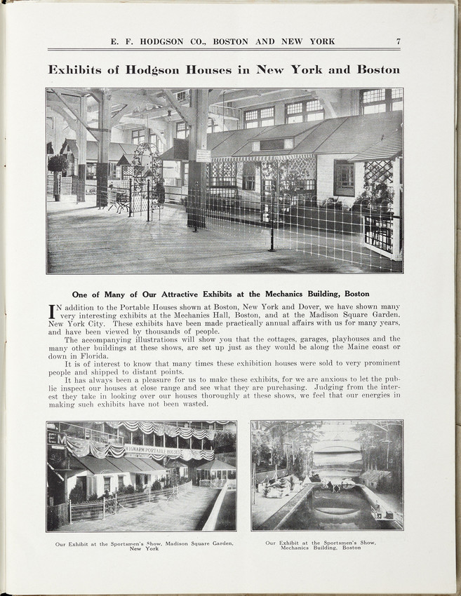
A page from a 1919 E.F. Hodgson catalog, from Historic New England.
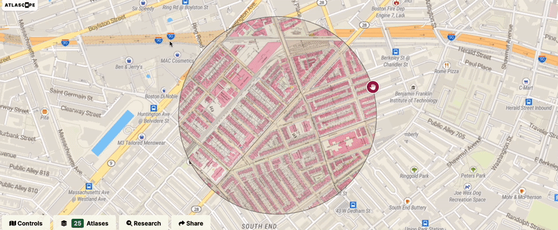
If you thought there isn’t much to see in this map of Dover from 1909, you’d be mistaken. Excerpted from a much larger atlas of towns in Norfolk County, this single plate contains a fascinating story in the E.F. Hodgson factory.
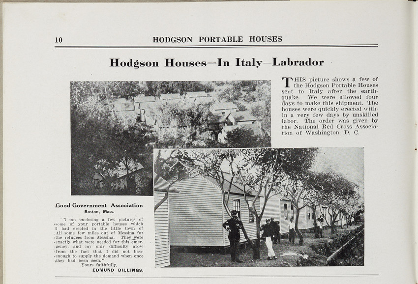
Founded in 1892, Hodgson was one of the earliest creators of prefabricated housing in the United States. Hodgson houses were primarily advertised in catalogs, but they were also showcased in public exhibitions. The catalog to the right, for example, highlights a 1919 exhibition at Mechanics Hall in Boston, just down the street from the Central Library. Hodgson Portable Houses were incredibly mobile; the next page in the catalog features “a few of the Hodgson Portable Houses sent to Italy after the earthquake.”
The turn of the twentieth century was a transformative time for urban and suburban development in the United States. Technologies like prefabrication not only created new ways of accessing housing, but new ways of thinking about home. By 1933, the architect George Fred Keck materialized these ideas in his “House of Tomorrow,” a futuristic structure designed for the 1933 World’s Fair that prompted attendees to consider the intersections between science, technology, and domestic life. Though perhaps less well-known to historians than Keck’s work, the Dover-built Hodgson Houses were certainly no less significant.
Just north of the factory in Dover, a wooden structure is listed as owned by one E.F. Hodgson. Presumably the home of the company’s eponymous founder, one has to wonder whether he lived in the very same products that came off his assembly line around the corner.
The inclusion of Dover in Atlascope is thanks to the sponsorship of the Dover Historical Society. Scroll to the bottom of this article to learn about how you can help get coverage of your own town into Atlascope!
Hull: The heydays of Nantasket Beach
In our current exhibition, Building Blocks, Laura Lee Schmidt writes that Revere Beach constituted a “landscape of marvels.” In the early twentieth century, amusement parks and fairgrounds could often found at the end of streetcar lines (often placed there by the streetcar companies themselves as an incentive to ride the whole line). The “marvels” in Revere Beach peaked around 1914, but nearly twenty years earlier, the town of Hull boasted its own landscape of marvels.
The 1895 Atlascope view of Nantasket Beach reveals a town that had only just begun to expand. Sagamore Head has been subdivided but hardly developed, while yellow buildings pockmark the coasts further north towards Allerton, indicating that construction at the time was mostly limited to desirable waterfront properties. Just across from the Nantasket Steamboat Wharf, however, we find the main drag of Nantasket Beach replete with fun and games, from shuffleboard, toboggans, and a merry go round to a dance hall, maze, and “automatic swing.”
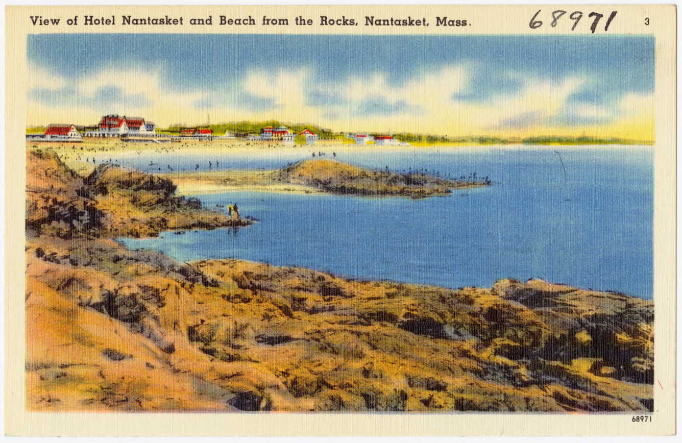
Postcard for the Nantasket Hotel, showing the rocky shores sometime between 1930 and 1945 (from the BPL Arts Department)
Papers held at the Library of Congress reveal that the connection between Nantasket and Revere Beaches was not merely incidental. In 1899, the Metropolitan Parks Commission hired a familiar firm—Olmsted Brothers Landscape Architects—to assess the redevelopment of Nantasket Beach. Just three years prior, in 1896, it had been the very same Metropolitan Parks Comission that contracted Charles Eliot to redevelop the beachfront promenade in Revere.
In both cases, the redevelopment came in response to activities and behaviors that were deemed unbecoming of a proper citizenry. According to Olmsted Brothers' 1899 report, Nantasket Beach featured its fair share of “buildings catered to ‘transients,'” including “hotels, bath-houses, photograph galleries, saloons and catch-penny establishments” which were viewed as “tawdry and shabby” impositions on the landscape. A striking passage on page 3 recommended that the state intervene:
“Physically the beach is not very badly off, and that it is not likely to get very much worse in that respect if left to unchecked private development… if concerted action were to be taken, the beauty and pleasantness of the beach could doubtless be very considerably increased.”
Lynn: “Like Webster’s dictionary, we’re Morocco bound”
When we turn the clock back to 1880 in Lynn, we find a fairly recognizable landscape. Downtown bustles with many institutions that are still recognizable today, including City Hall, St. Stephen’s Memorial Church, St. Mary’s Church, and the Lynn Common. Making our way north up Franklin Street, however, we find something unfamiliar: a set of buildings nestled between Pine Grove Cemetery and an anonymous brook, bearing the curious label “Morocco Factory.”
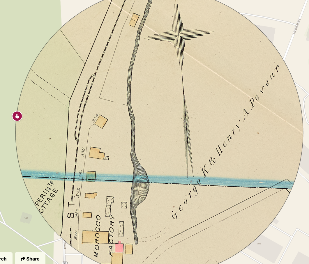
Screenshot of George K. and Henry A. Pevear’s morocco factory in Atlascope
To modern ears, this phrase might not make much sense, but a late-19th century Bay Stater would have easily recognized it as a leather factory. Morocco leather, or simply “morocco” in most cases, is a kind of leather made from goatskin. Known for its pliability, softness, and distinctive colors, morocco was used commonly in wallets, luggage, and the uppers of shoes. Morocco manufacturers were common in New England, with known locations in Acton and Boston as well as Lynn. The leather itself was was popular enough—especially as a material for bookbindings—that Bing Crosby and Bob Hope’s 1942 song “(We’re Off on the) Road to Morocco” includes the line, “like Webster’s dictionary, we’re Morocco bound.”
An 1898 issue of The Register of the Lynn historical Society notes that the business of “morocco dressing… had long gained a foothold on the brook.” Indeed, just southwest of the factory owned by George A. and Henry K. Pevear, at the corner of Boston and Washington Streets, we can see a competing “Morocco Works” apparently owned by Shute & Faulkner. Eight years after this atlas was printed, that morocco works would catch fire in what The New York Times called “the most disastrous conflagration that has visited that city for a year.” The owners appear to have rebuilt the factory by 1905, the next year for which we have Atlascope coverage of Lynn. It is perhaps not surprising that in doing so, they incorporated brick—indicated by the pink shading—into the building’s frame.
Want to see your town in Atlascope?
We’re continuing work this summer and fall to add dozens more Massachusetts towns to Atlascope. There’s much more to be discovered in these atlases; your town may not have been the capital of prefabricated housing, a center for themed rides and dance halls, or a hub in the world of morocco goods, but we’re positive it has its own unique story and historical tidbits scattered through these atlas pages!
However, we need help from you and your communities to make this happen. Transforming a single town atlas from printed pages into a modern, readable web-layer is both costly and time-consuming, taking dozens of hours of skilled staff labor.
We are currently fundraising to support the labor it takes to transform and ingest each physical atlas into Atlascope for usage and discovery. If you’d like to see your town in Atlascope, and you know institutions, groups, or community members who’d like to help gather the funding to support this, please visit this page for more information, or reach out directly to our Development Coordinator, Rachel Sharer.
As we add atlas layers in the coming year, we will prioritize towns that are funded by our partner institutions. So far we’ve received support from local libraries, museums, educational institutions, and historical community groups, and we’d love to add your name to our list of sponsors!
With your help, we’re excited to make Atlascope a tool for groundbreaking historical research and urban discovery across the whole state of Massachusetts.
Our articles are always free
You’ll never hit a paywall or be asked to subscribe to read our free articles. No matter who you are, our articles are free to read—in class, at home, on the train, or wherever you like. In fact, you can even reuse them under a Creative Commons CC BY-ND 2.0 license.