Calling all cartography lovers!
Get ready to see some of the newest acquisitions to our collection of over 250,000 maps, atlases, globes, and other cartographic objects. We are always adding new materials to our collection, and this program is a chance to see what has recently arrived.
Walt Disney Company, Race 'round the world with Mickey Mouse and the Big Bad Wolf (1936)
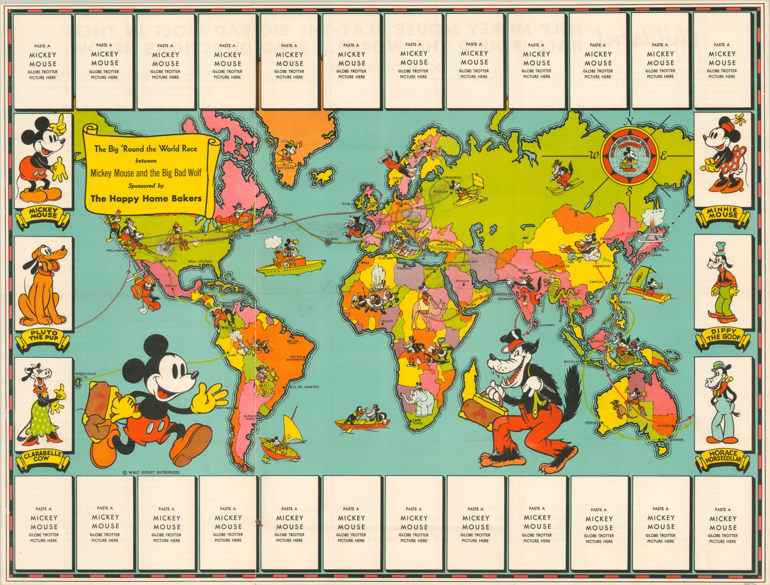
This map is an early example of a shift in marketing strategy when companies began advertising directly to children. This campaign was designed to promote the sale of a new and innovative product – sliced bread! This map depicts two recognizable characters from the up-and-coming Walt Disney Co., Mickey Mouse and the Big Bad Wolf, racing around the globe, and the only way to find out their locations was by buying loaves of bread. Bread with a special “Mickey Mouse Band” would contain a small trading card and allowed the purchaser (or their child) to follow the progress of the race “across the world.” Blank spaces at the top and bottom of the map allowed for the display of the entire collection of bread tabs.
Numerous images within the map show various means of transportation, encounters with local wildlife, and stylizations of local people and customs. It is important to recognize that this map depicts racist caricatures of indigenous people in Africa and Southeast Asia. This can help us as the viewer more deeply understand the culture from which this map emerged—advertising cartoons and sliced bread to children while perpetuating incredibly harmful depictions of the global south.
L. Sunderland, Birds eye view of the “Cottage City” Marthas Vineyard, Mass (1880)

A lithographic view of Cottage City (later Oak Bluffs) on Martha's Vineyard, Mass. The imagined view is shown from a high vantage point with Vineyard Sound in the foreground. The street plan of Cottage City is shown with individual buildings, parks, wharves, Lake Anthony, and Meadow Lake. Cottage City was a popular summer resort and the site of both Methodist and Baptist camp meetings. In the early twentieth century, the area became a popular destination for middle-class Black families seeking a reprieve from segregation and discrimination. This tradition continues today, with Oak Bluffs serving as a cultural hub for many African Americans.
Massachusetts Development and Industrial Commission, Choose Massachusetts for vacation variety (1949)
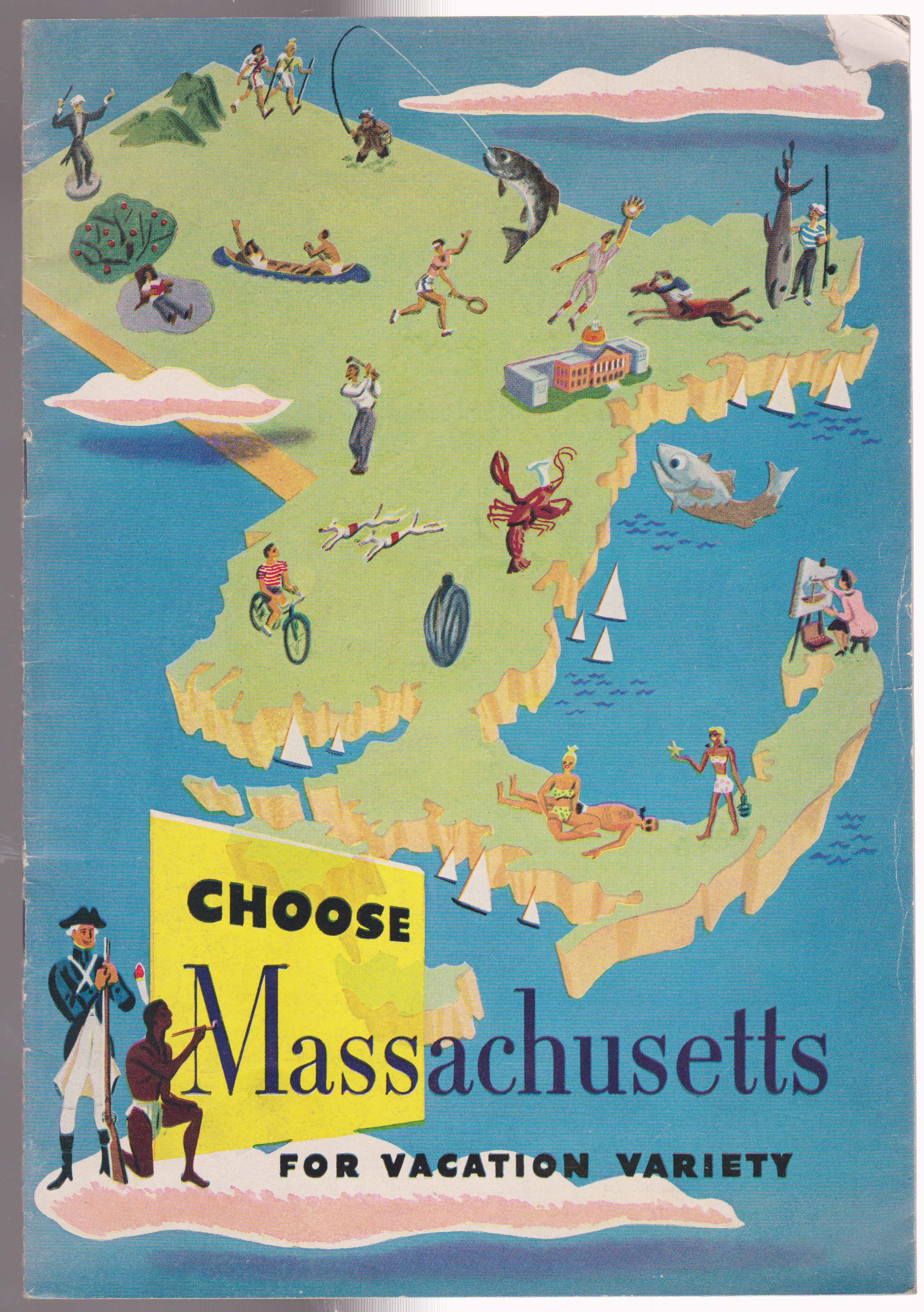
In the time directly following WW2, the United States developed a new wave of middle class Americans. At a time when national highways were fully developed, the average American had access to a vehicle, and had the time and money for a vacation, each state was eager to draw in new visitors. This map and brochure developed by the Massachusetts Development and Industrial Commission was intended to serve that exact purpose for Massachusetts. With appeals to visitors seeking the countryside, rich historical ties, the seaside and much more, this brochure promised that Massachusetts could provide any vacation folks were interested in.
Harless, Matthew, Unmapped Boston its squares, hills, neighborhoods and thoroughfares (2006)

This stylized map of Boston is one that may resemble an MBTA map from afar with the familiar red, green, orange, and blue splashed across the city’s landscape. However, when taking a closer look, it’s evident this map is doing something much different. While Boston is dotted with a host of “squares, hills, neighborhoods and thoroughfares”, it’s rare to see these areas so formally mapped. Through the overlapping and interconnected lines, this map intends to show viewers the breadth of Boston’s communities.
Historical Map of the U.S. [approximately 1930s]
Map of the United States [approximately 1930s]
Map of the East [approximately 1930s]
Likely created by school children, these maps are examples of embroidery samplers, a piece of embroidery or cross-stitch produced as a “specimen of achievement” and were considered a demonstration or a test of skill in needlework. Maps were often chosen as the subject of samplers, as they served a dual purpose. The first was that it required multiple embroidery techniques, calling for students to put in real time and attention into their work. The second is that it familiarized students with the geography of their country and encouraged a sense of national pride.
These maps have not yet been digitized. Make a research appointment to see them in person.
Geo. H. Walker & Co., Plan of Boston & Maine R.R. export terminals, Boston (1905)
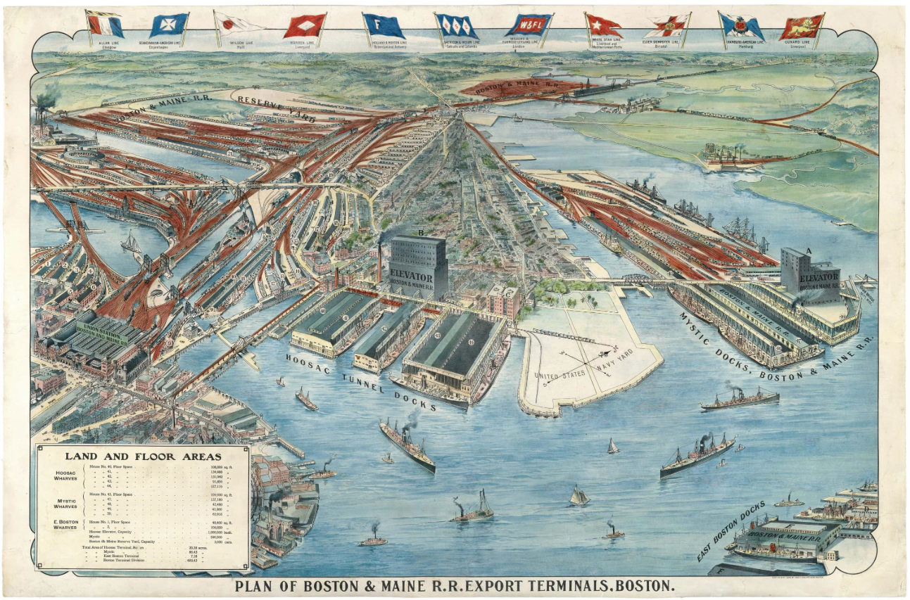
This unique bird’s eye view of the Boston harbor looks north, with the North End at left, Charlestown at center and right, East Boston in the lower right, and Cambridge, Somerville, and Chelsea in the background. The image is primarily focused on the rail lines of the Boston & Maine Railroad, clearly seen in a red-orange color. Converging on Union Station (now North Station) and its port facilities, the true size of the Boston & Maine Railroad was greatly emphasized through some artistic interpretation, like the omission of the Bunker Hill Monument.
Our articles are always free
You’ll never hit a paywall or be asked to subscribe to read our free articles. No matter who you are, our articles are free to read—in class, at home, on the train, or wherever you like. In fact, you can even reuse them under a Creative Commons CC BY-ND 2.0 license.