It's the season of love and that means sharing the maps the Leventhal Center loves with the public!
Maps have so much to offer—from the rich history behind their creation and visual perspectives of familiar places to the depth of information they communicate and so much more. While the staff at the Leventhal Center have a special place in our hearts for all of our maps, there are just a few that each of us love the tiniest bit more than the others.
In this From The Vault selection, take look at the personal favorites of the staff at the Leventhal Center and learn about the multitude of reasons these maps have captured our attention amongst our collection of over 250,000 maps.
Boston Redevelopment Authority, Shadow analysis (1990)

A series of these maps were recorded during the Summer and Winter solstice (the days with the longest and shortest amount of daylight) at the same times of day in 1990 and shows building shadows in Downtown Boston and Back Bay. Looking between the maps clearly illustrates the distinct lack of shadows at midday during the summer months compared to the city-sprawling shadows of the winter. Maps like these are used to visualize one way building structures can impact the larger landscape and communities around them.
Julia: Though you typically think of mapping in association to the physical land, I find it so interesting when maps are used to bring context to more untraditional subjects, like shadows in this case!
Geo. H. Walker & Co, Bird's-eye View From Summit of Mt. Greylock, Berkshire County, Mass (1906)

This striking perspective from the summit of Mount Greylock in western Massachusetts shows us the view from the state’s highest point. The George H. Walker publishing firm was famous for its beautiful bird’s-eye views of parks and preserves, and they produced a similar 360° view from the summit of Mount Washington in New Hampshire. This much rarer 1906 view from Greylock takes in the rolling landscape of the Berkshire Hills and looks out on the horizon towards peaks as distant as Mount Marcy in the Adirondacks and Mount Monadnock in southern New Hampshire.
Garrett: I love how this map embodies the viewer as though they were standing on the mountain, even though it is using a totally impossible and unfamiliar point of view.
Gilles Robert de Vaugondy, Carte de l'Egypte ancienne et moderne: dressée sur celle du R. P. Sicard, et autres assujetties aux observations astronomique (1753)

Few maps give as much detail to the observer as this 1753 French depiction of Egypt. This map showcases the locations of cities both ancient and modern, as well as hydreumata (watering holes) and the trade routes along which they were located. A small dictionary of Arabic words useful for navigation is even included at the bottom of the map.
Alex F: One of my favorite details of this map is the cartouche, which combines an (admittedly outdated) artistic depiction of the region with important details about the map and its creators.
Ferdinand Cartwright Ewer, Historical map of Nantucket (1869)

The three-century timeline of historical events makes this 1869 map of Nantucket unusual, but its place nomenclature makes it remarkable. With an uncanny monospace font, the map superimposes four "Territories of Sachem"—including "Potcone," "Autopscot," "Wauwinet," and "Wanackmamack"—upon English place names, while a dotted line in the legend signifies "Boundaries of the Ancient Sachem Rights." However, the place names and land claims of Nantucket's indigenous people are preserved here only as a matter of "historical" significance; thus, in acknowledging these indigenous geographies, the map also enacts a perverse kind of colonial erasure.
Ian: This map makes me think about how seemingly mundane cartographic choices, like a font style or a dotted line, can have a lot of power over what we remember and forget.
Ruth Chrisman Gannett, Map of the island of Tangerina and Wild Island (1986)

Tigers, whales, dragons—oh my! This map follows Elmer Elevator’s adventurous journey from the Island of Tangerina to Wild Island in My Father’s Dragon, where he sets out to rescue a baby dragon. From dangerous ocean crossings to grumpy animals guarding the island, the map helps readers visualize each obstacle in Elmer’s quest.
Kiana: This is my favorite map, because a group of elementary school students enthusiastically told me about the time they read My Father’s Dragon with a teacher, a sibling, or parent.
Louise E. Jefferson, Uprooted people of the U.S.A. (1945)

This map shows the movements of “25,000,000 Americans who have been physically uprooted” between 1940 to 1945. What’s uprooting them? Cartographer Louise Jefferson shows us by weaving together the historic events of this era. In these five years, millions of Americans joined the war efforts for World War II. Millions of African Americans moved north in the Great Migration. Refugees fled the aftermath of the Dust Bowl. The federal government unjustly imprisoned over 120,000 Japanese Americans in so-called “relocation centers”. All these stories unfold at once on this map next to scenes of everyday life. Jefferson’s choice not to draw state lines gives a sense that something truly national was unfolding.
Alex J: I love this map because maps rarely show people, and almost never show a feeling of uncertainty. Jefferson’s map captures both. And every picture she’s drawn here tells a story on its own!
Don Bloodgood, Navajoland, U.S.A. (1960)

Published by the Navajo Tribal Council Parks Commission in 1960 as a brochure for visitors, this map identifies natural, historical, and cultural landmarks, including the oldest continuously inhabited village in the United States! The markers are supplemented by large, detailed drawings of map features scattered around the map’s edges.
Ashton: I love the bright colors, personable drawings, comprehensive detail, and easy readability of this map. It's also interesting to see what was determined “important enough” to highlight and offers a small window into the intersection between what someone might value about their own home and what an outsider might value when visiting. If you were to map your favorite place, what would you include?
Robert de Vaugondy, Les grandes et petites isles Antilles, et les isles Lucayes avec une partie de la mer du Nord (1779)

In this cartouche, we see echoes of contemporary still lives. This is not just a randomly assembled gathering of objects: we see a celebration of the maritime world that brought these islands under the thumb of Europe. We have ships bookending the bottom corners and a symmetrical assortment of sea shells in between. The cherubic winds are blowing gleefully at the top. The precision in the drawing and the order of the assemblage balances nautical whimsy with steady control.
Nicole: I only have eyes for the cartouche on this map. It’s giving a strong Age of Enlightenment energy to my art historical eyes. As European nations started colonizing, some still life paintings started cataloging the spoils of these conquests. The carefully assembled groupings of fruits and flowers showed off not only the mastery of the artist over paint but could also signal domination of their country over the colonial world in the goods displayed. Fruit is never just fruit to me.
Keith Thompson, The Great War, 1914 [2009]
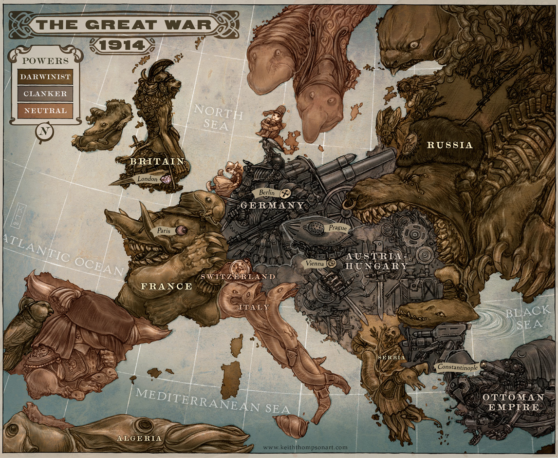
This map is from Scott Westerfeld's young adult novel Leviathan, the first novel in a steampunk/biopunk trilogy that reimagines World War I in a technologically advanced alternate world. Darwinists, corresponding to the Allies, use biotechnology to fabricate creatures like the whale-based airship, the Leviathan. The Central Powers equivalent, the Clankers, build steam-powered machines to wage war. The series follows Deryn, a girl disguised as a boy to serve in the British Air Service, and Aleksander, son of assassinated Archduke Franz Ferdinand, on their travels aboard the Leviathan.
This map depicts European countries in the style of caricature maps, which were popular in the late 19th to early 20th centuries and represent countries using stereotypes and symbols for political, satirical, or humorous commentary.
Lauren: This was one of my favorite series and the map is a fun representation of this literary world.
Warner Bros. Pictures, The adventures of Mark Twain [1944]

Published by Warner Bros. Pictures to promote the 1944 biopic starring Fredric March, this pictorial map turns the American landscape into a storyboard. It traces Samuel Clemens' evolution from a Mississippi riverboat pilot to the global literary icon, Mark Twain, linking his geographic journey to his bibliography. The map anchors his most beloved characters to their real-world inspirations: Hannibal, Missouri is not only as a hometown, but also as the eternal playground of Tom Sawyer and Huckleberry Finn. Released during World War II, the map creates a specific narrative. Notice the prominent eagle and the central quote about "ideals of democracy." By linking Twain and American works to these patriotic themes, the map reimagines the humorist as a symbol of American freedom and resilience during a time of global conflict.
Carlos: I love this map because it transforms a linear biography into a spatial journey, treating literary characters as landmarks just as tangible as the Mississippi River itself.
Our articles are always free
You’ll never hit a paywall or be asked to subscribe to read our free articles. No matter who you are, our articles are free to read—in class, at home, on the train, or wherever you like. In fact, you can even reuse them under a Creative Commons CC BY-ND 2.0 license.