This digital publication was supported by the Leventhal Map & Education Center's Small Grants for Early Career Digital Publications program.
Vertebrates and invertebrates. Fossil footprints. Rock strata of local regions in Massachusetts and international areas across Europe. These vibrant illustrations---constructed out of large swathes of common household fabrics illustrated with ink and watercolor---are some of more than sixty geological maps and diagrams crafted by early American scientific illustrator Orra White Hitchcock.


Fossil footprints discovered and named by Edward Hitchcock

Map of the Connecticut River Valley after Edward Hitchcock’s published 1817 map of the same region that was hand colored by Orra. It is the earliest detailed geological map of an American region.

Strata across Massachusetts after an engraving in Edward Hitchcock’s 1832 geological report of Masschusetts

Section of the Tyrolese Alps after a hand colored engraving by prominent English geologist Henry de La Beche
Hitchcock crafted these maps in the late 1830s to facilitate student learning in the Amherst College classrooms of her husband, leading early nineteenth-century geologist Edward Hitchcock. These massive textile maps were not the Hitchcocks' first collaborative endeavor; since meeting over a decade prior, the two had worked together on numerous projects. As Edward surveyed the geology of the state, White Hitchcock sketched, drew, and hand-colored hundreds of maps and diagrams for his publications and classrooms, making the state's geology accessible to popular and professional audiences alike. (These collections have now been made newly accessible via Amherst College's digital collections.) White Hitchcock was so integral to the success of her husband's scientific career that "it is probable that [Edward] would not have been anything great, if [she] had not assisted him by her drawings of everything appertaining to his study of Geology," as 1849 Amherst College graduate Martin Root suggested in his diary.1
The pair was working at a moment when the relatively young scientific discipline of geology was still closely connected to cartography and geography. All of these pursuits sought to describe, define, and map the earth through text and image.2 With images in particular, geologists, geographers, and cartographers strove to demarcate the land claims of imperial expansion, chart the nation’s rapidly growing borders, map the mineral resources of states, and display views of the earth’s interior rocks and fossilized creatures.3 The new nation was being plotted and surveyed so quickly that an 1846 issue of the tongue-in-cheek American periodical Yankee Doodle declared: "The young empire grows so fast that it must have a new suit of maps throughout every year."
Geology maps and diagrams were marketed as objective educational materials, but in actuality, they shaped American science, culture, and politics in a significant way, from views of the country's natural resources to new ideas about the age and structural makeup of the earth that challenged Christian biblical history. Rather than reading such objects for their style or iconography, focusing on the materials and techniques used to create them by makers like White Hitchcock reveals how white women utilized their craft in service of colonial scientific study in the early American republic.
Women Working in Geology
White Hitchcock was part of a quickly growing group of middle- and upper-class white women who were intimately involved in mapping the natural landscapes, built environments, and geology of the new American Republic. Working as illustrators, cartographers, and colorists, as well as map sellers, engravers, publishers, and globe makers, these women usually got into the work through close male relatives, the family business, or via marriage.
Starting in the 1830s, more and more women enabled the discipline's development as they mapped, hand colored, and illustrated the country's geology. They drafted stratigraphic cross sections of the country's interiors, painstakingly hand colored large geological maps for scientific journals, and sketched drawings of fossils, minerals, and landscapes that filled the pages of geological state survey reports.5 Their handiwork skillfully created attractive and accurate visual evidence of America's landscapes and rocky interiors.
Before 1850, one of the primary means by which geological research was circulated in the U.S was through state-financed geology survey reports.6 The reports communicated much of their crucial scientific information through drawings (used as the basis for printed woodcuts and lithographs) by these women crafters. White Hitchcock, for example, sketched most of the 275 woodcuts and over a dozen of the 55 lithographic plates for her husband's Massachusetts state survey first published in 1833. Similarly, Sarah Hall drew many of the scenic and technical plates for the 1836 New York state geological survey report. The report, directed by Sarah's husband James Hall, also featured paleontological illustrations by a woman, Mrs. Brooks, who was not associated with the family.7
Large geological state maps were published in or alongside these reports. They benefitted scientifically and commercially from the addition of color, much of which was done by women. Until the 1850s when multi-colored maps became readily reproduceable with new color printing technologies, geologists relied on hand coloring to tint maps and diagrams. Map coloring work demanded fine artistic expertise---just the sort of drawing and painting skills that young middle- and upper-class women had acquired in their early education. In need of employment after completing their studies, many of these women, especially past decorative arts instructors, worked as map colorers.In cities from Boston to Philadelphia and New York, they painted a few map copies per day, applying individual watercolor tints carefully by hand to delineate the geological character of newly surveyed regions of the country.
The Craft of Decorative Mapmaking
Women illustrators developed the decorative art skills necessary for geological mapping and illustration at female seminaries and academies that sprang up across the country in the decades following the American Revolution. Alongside their core curricular courses, young women took arts classes, becoming well versed in techniques ranging from drawing and watercolor painting to embroidery, often spending upwards of three to six months working on a single project.8
At times lavish and large and at others elaborate and miniature, the projects were designed to fill domestic spaces, adorning the walls of parlors or displaying beautifully atop furniture. To effectively create these eye-catching artworks, students often had to master multiple artistic techniques---think stenciling, collage, and all types of stitching. Because of this, they learned to manipulate all manner of different artistic materials like watercolor paint, pencil, pen, thread, ribbon, and fabric within one art object.
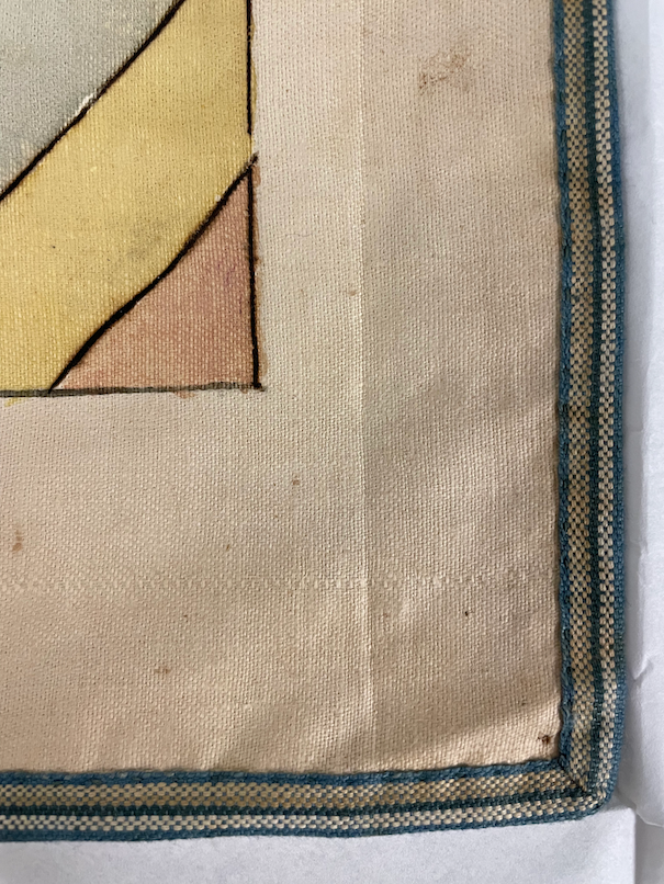
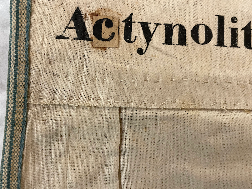
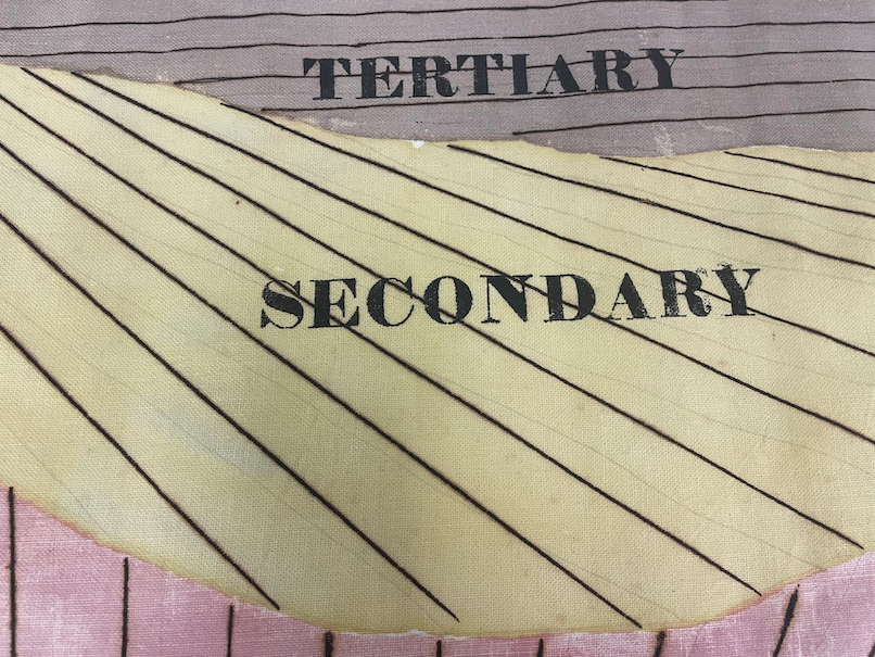
White Hitchcock’s geology classroom charts highlight the use of multiple artistic techniques within one art object—in this case, a scientific illustration. Each chart was cut out of large sheets of cotton and bordered with cotton fabric tape typically used to hem dresses and household linens.
Some of the charts were so large (upwards of 14 feet long) that they required multiple swathes of cotton to be pieced together, like this chart of a tabular view of rocks.
Stenciled letters were applied to title each chart and notate key rock types.
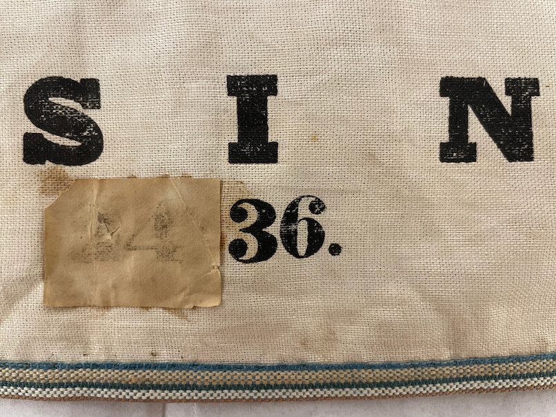
Stenciled numbers were added to the bottom of each chart so that Edward or his colleagues could easily request a visual aid by referencing its number.
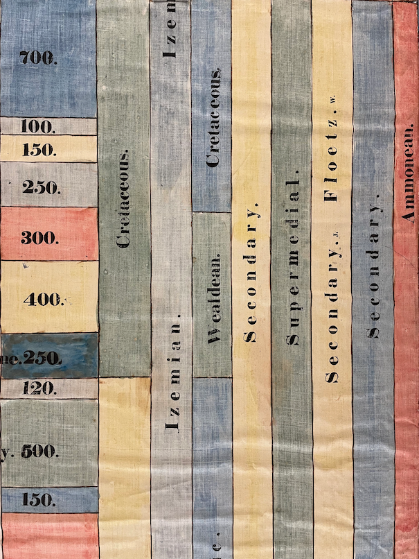
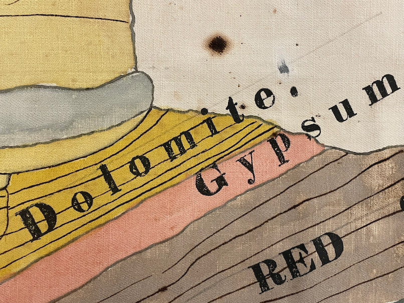
White Hitchcock employed a wide and vibrant watercolor paint palette predominantly featuring reds, blues, yellows, greens, and grays, though sometimes also pink and purple shades.
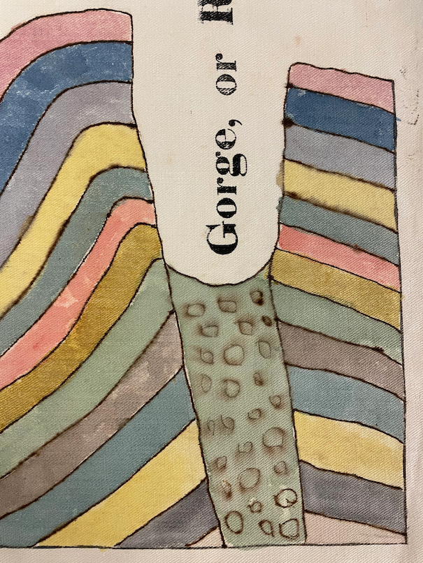
Watercolors made local and international cross-sections visually pop, with easily distinguishable rock bands.
Dark black and brown inks added further detail to the geology illustrations. Before committing to inked outlines, White Hitchcock laid out the image with a pencil sketch, as can be seen here in the chart of stratified rocks.
One project commonly assigned at schools throughout New England and the Mid-Atlantic to complement geography instruction was decorative mapmaking. Worked out of ink and watercolor or embroidery, these maps were copied from engraved maps in small portable geography textbooks and atlases.9 There was significant fervor around these mapmaking practices with teachers holding celebratory map exhibitions or staging competitions in map drawing and reading.10
Three remarkable examples of these decorative maps all made around 1820 by schoolgirls Eliza Tileston, Abigail Dunbar, and Mary Johonnot are housed in the Leventhal Center's collections. Tileston and Dunbar focused their artistic efforts on copying the state and its county boundaries, towns, and riversfrom unidentified print sources, while Johonnot endeavored to chart the entire United States by reproducing a national map from a geography textbook published years earlier. Per material culture historian Martin Brückner, undertaking this reproduction process from atlas to blank schoolbook required the young women to "draft map[s] to scale while incorporating the same contents found in small, printed maps."11 They enacted these material shifts in scale either by transforming print originals into handmade maps at a larger display size or at a small handheld size. Johonnot's map is an excellent example of the latter: at just 5½ × 7 inches, the map of the nation rests comfortably, even intimately, in an outstretched palm.
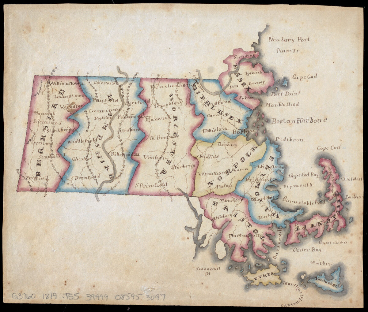
Map of Massachusetts by Eliza Tileston, 1819
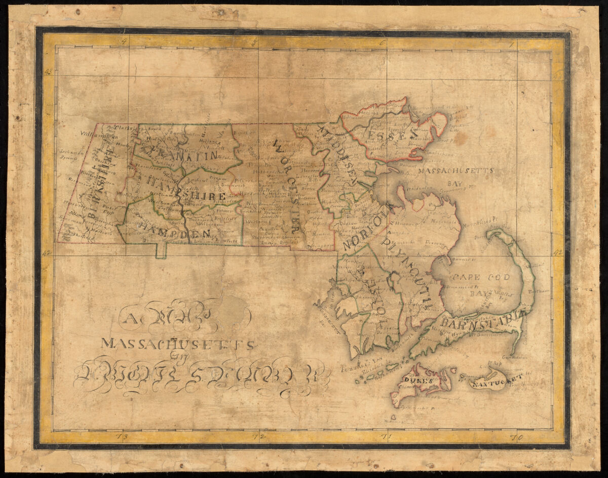
A Map of Massachusetts by Abigail Dunbar, ca. 1800-1820
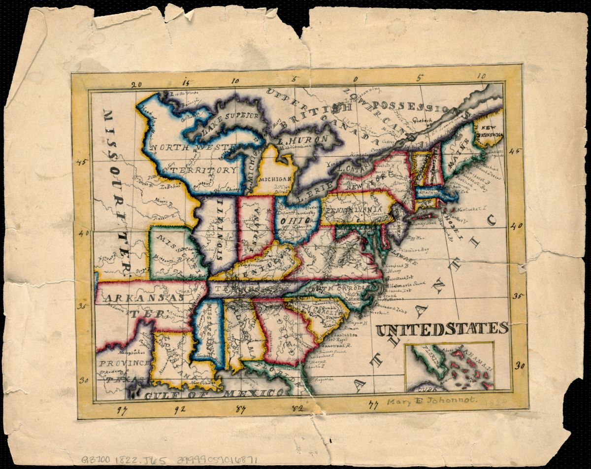
United States by Mary E. Johonnot, 1822
The maps are striking in their shared color palette, reminiscent of the one used by White Hitchcock in cross-sections of Massachusetts and the Alps. Vibrant and contrastingreds, yellows, greens, and bluesdelineate county lines. To varying degrees, the colors are applied with an ombré effect. More saturated tones anchor the borders, lightening as they as bleed into the county interiors. A warm yellow wash, used by both Dunbar and Johonnot, fills the maps' outer rectangular borders, mimicking formal cartographic standards.
At the same time as young women like these created decorative maps, their male peers were conducting land surveys at academies, and older adults practiced similar artistic techniques as a genteel pastime.12 Which is to say: young women were part of and actively shaping a larger cultural milieu of artistic practice in mapping the earth's features.13
Crafting Geology: The 1832 Geological Map of Massachusetts
When hand coloring geology maps and illustrations, women typically followed a few basic principles prescribed by the scientific community. They applied colors so that no two similar hues were side by side. And they did so with the same intensity, a delicate balance of a dark enough hue to create readily distinguishable colors, but no color too strong or saturated to obscure the outline of the map or stratigraphic cross section. They used color to create visual uniformity, ensuring all viewers could easily ascertain scientific meaning of a map or diagram.
This was no less the case with Edward Hitchcock's 1832 geological map of Massachusetts. During 1830 and 1831, he drafted and re-drafted the map to be included in the state report---the first of its kind to be included in such a survey. At 18 by 28 inches, it was a large map that Edward wanted fully colored.
Perhaps because White Hitchcock's time was already filled drafting diagrams for the report and making the classroom charts, Edward outsourced the map coloring labor. He employed the map engraver's daughter, Sarah Doolittle, at the recommendation of his mentor Benjamin Silliman, esteemed Yale professor and founder of the American Journal of Science. Described by Silliman as "a good artist...a young lady who paints & draws & has acted as a teacher of these things in Charleston So Car," Dolittle made a living painting maps.14 Hired by Edward at a rate of $5 per hundred copies, shehand-colored map after map,applying to each five light color washes indicating rock type (further classified with 18 printed background patterns) and nine colored symbols denoting the location of ore, checking for uniformity and correctness between copies as she went.
Maintaining visual consistency between copies was extremely challenging and demanded a steady hand and careful eye, but it was essential to circulating scientifically accurate geological maps. The two copies of the geological map in the BPL's digital collections highlight the difficulty of this labor-intensive process. Though both were part of the 1832 print run and presumably colored in the same batch, there are small differences in color choice and saturation. Zooming into the map key for the first group of rock types, we can see that map colorer opted for anincredibly light pink wash on the Leventhal copyin comparison to alight brownish orange on the Knafel Map Collection copy.Even for someone as artistically and scientifically skilled as Doolittle, it was incredibly challenging to accurately reproduce colors for the editioned geology map.15
Working with a range of common hues like Prussian blue, lake, sap-green, gamboge (a shade of yellow), and distilled verdigris (a rich shade of green), Doolittle denoted the mineralogical character and relative age of individual rock formations.16 She applied this brilliant range of colors to the map while keeping in mind the aesthetic associations of Western watercolor painting traditions premised on visual harmony that she had learned at school.17 In this way, she wielded color to convey physical and ideologically-laden theories about the earth and thus created an easily digestible, Westernized narrative of how human and geological histories are interconnected.18
Conclusion
Geology, as a discipline driven by scientific theoretical and national interests, was a domain for America's scientists to create purportedly objective visual guises to accelerate resource extraction, rapidly intensify territorial expansion through land dispossession, and rewrite human historical narratives throughout earth's history. Women like White Hitchcock and Doolittle used their decorative arts training to create these visuals, mapping and diagramming the earth and its interiors. Examining the material intricacies of their work reminds us that we would do well to further explore nineteenth-century women’s manipulation of craft methods and techniques—labor that underlies the development of modern sciences as we know them today.
Allison Fulton is a Ph.D. Candidate in English with a designated emphasis in Science and Technology Studies at the University of California, Davis. She is at work on a dissertation on how nineteenth-century gendered craft traditions and technologies shaped the emergence of the modern American scientific establishment. Allison is the Albert M. Greenfield Dissertation Fellow 2023-2024 at the Library Company of Philadelphia and a 2024 Stacy Lloyd Fellow for Bibliographic Study at the Oak Spring Garden Foundation. Her work has also been supported by the American Antiquarian Society, Winterthur Museum, and Historic Deerfield, among others.
Notes
1. Daria D'Arienzo, "The "Union of the Beautiful with the Useful": Through the Eyes of Orra White Hitchcock," The Massachusetts Review 51, no. 2 (Summer 2010): 304-305.
2. J.C. Greene, "Interrelations of Geography, Cartography and Geology in Early American Science," in Contributions to the History of Geological Mapping: Proceedings of the Xth INHIGEO Symposium 16-22 August 1982, Budapest, Hungary, ed. E. Dudich (Budapest: Akadémiai Kiadó, 1984), 93-94.
3. Martin Brückner, The Social Life of Maps, 1750-1860 (Chapel Hill, NC: University of North Carolina Press, 2017), 123. In this essay, I define maps and mapping very capaciously, including cartographic, topographic, and geologic maps; landscape scenes; abstract diagrams; specimens; etc. Any image early American image that charted the earth's interior or exterior I consider a map.
5. This was not a distinctly American phenomenon. British women (notably, all wives of prominent British geologists) like Mary Morland Buckland, Mary Horner Lyell, and Charlotte Hugonin Murchison illustrated their husband's geological works ("19th-Century American Women in Science," Impressions).
6. Carol Siri Johnson, "The Evolution of Illustrated Texts and Their Effect on Science: Examples from Early American State Geological Reports," Leonardo 41, no. 2 (2008): 120-127.
7. Michele L. Aldrich, "Women in Geology," in Women of Science: Righting the Record, eds. G. Kass-Simon and Patricia Farnes (Bloomington: Indiana University Press, 2010), 45. Women's handiwork continued to appear throughout American state surveys well throughout the century: Mrs. Myers collaborated with Fielding Bradford Meek on the Illinois reports, Kate Andrews drew for the 1875 Ohio survey, and Harriet Hunstman drew for the 1898 Kansas survey.
8. For instance, students at Troy Seminary, established by prominent early American female educator Emma Willard, had drawing classes alongside courses in geology taught by Amos Eaton, leading American geologist and Rensselaer Polytechnic Institute professor. Similarly, geology and the decorative arts were taught from the earliest days Mount Holyoke's founding as a secondary school (Michele L. Aldrich, "Women in Geology," in Women of Science: Righting the Record, eds. G. Kass-Simon and Patricia Farnes (Bloomington: Indiana University Press, 2010), 44).
9. Judith Tyner, "Following the Thread: The Origins and Diffusion of Embroidered Maps," Mercator's World 6, no. 2 (March/April 2001): 37; Susan Schulten, "Map Drawing, Graphic Literacy, and Pedagogy in the Early Republic," History of Education Quarterly 57, no. 2 (2017): 199.
10. Jane C. Giffen, "Susanna Rowson and her academy," Antiques 98, no. 3 (September 1970): 437. Student-made decorative maps were some of the first cartographic objects to be made and used in American classrooms.
11. Martin Brückner, The Social Life of Maps, 1750-1860 (Chapel Hill, NC: University of North Carolina Press, 2017), 287.
12. Joan Irving, ""My Dear Mr. Du Pont...": Connoisseurship of Maps at Winterthur," Winterthur Primer, Saturday, 16 November 2013, https://www.incollect.com/articles/my-dear-mr-dupont
13. Jane C. Nylander, "Useful and Ornamental Education for Young Ladies: Mrs. Rowson's Academy, Boston, 1797-1822," New England Ancestors 7, no. 1 (Winter 2006): 19-26; Schulten, "Map Drawing," 184, 186.
14. Robert Herbert, "The Complete Correspondence of Edward Hitchcock and Benjamin Silliman, 1817-1863," 26, 132.
15. R.A. Skelton, "Colour in Mapmaking," The Geographical Magazine 32, no. 11 (April 1960): 553; Karen Severund Cook, "From False Starts to Firm Beginnings: Early Colour Printing of Geological Maps," Imago Mundi 47 (1995): 159. If a hand-colorer ran out of color, and a new one would be substituted.
16. E.E. Milanovsky, "Evolution of the Geological Map Content Relative to the Development of Geological Science," in Contributions to the History of Geological Mapping: Proceedings of the Xth INHIGEO Symposium 16-22 August 1982, Budapest, Hungary, ed. E. Dudich (Budapest: Akadémiai Kiadó, 1984), 5.
17. I share with Ulla Ehrensvärd that assertion that to properly analyze the historical significance of color in cartography we need to treat "aesthetic aspects of color as inextricably bound up with function" ("Color in Cartography: A Historical Survey," in Art and Cartography: Six Historical Essays (Chicago: University of Chicago Press, 1987), 123.
18. Nicolaas A. Rupke, "'The End of History' in the Early Picturing of Geological Time," History of Science 36, no. 1 (1998): 61; David Sepkoski, "The Earth as Archive: Contingency, Narrative, and the History of Life," in Science in the Archives: Pasts, Presents, Futures, ed. Lorraine Daston, (Chicago: The University of Chicago Press, 2017), 60-61; Simon Naylor, "Geological Mapping and the Geographies of Proprietorship in Nineteenth-Century Cornwall," in Geographies of Nineteenth-Century Science, ed. David N. Livingstone (Chicago: University of Chicago Press, 2011): 358.
Our articles are always free
You’ll never hit a paywall or be asked to subscribe to read our free articles. No matter who you are, our articles are free to read—in class, at home, on the train, or wherever you like. In fact, you can even reuse them under a Creative Commons CC BY-ND 2.0 license.