Shaping the face of the US after WWII
At first glance, the 1950s map of the United States depicted below—Illustrierte karte der Vereinigten Staaten von Amerika—doesn’t appear to share much information for American viewers (unless, of course, those viewers can read German). However, a closer look provides insight into growing American geopolitical influence, U.S. interests in defining German perceptions of America, and even some insights into how the U.S. state imagined its own regionally distinct cultural and economic geographies.
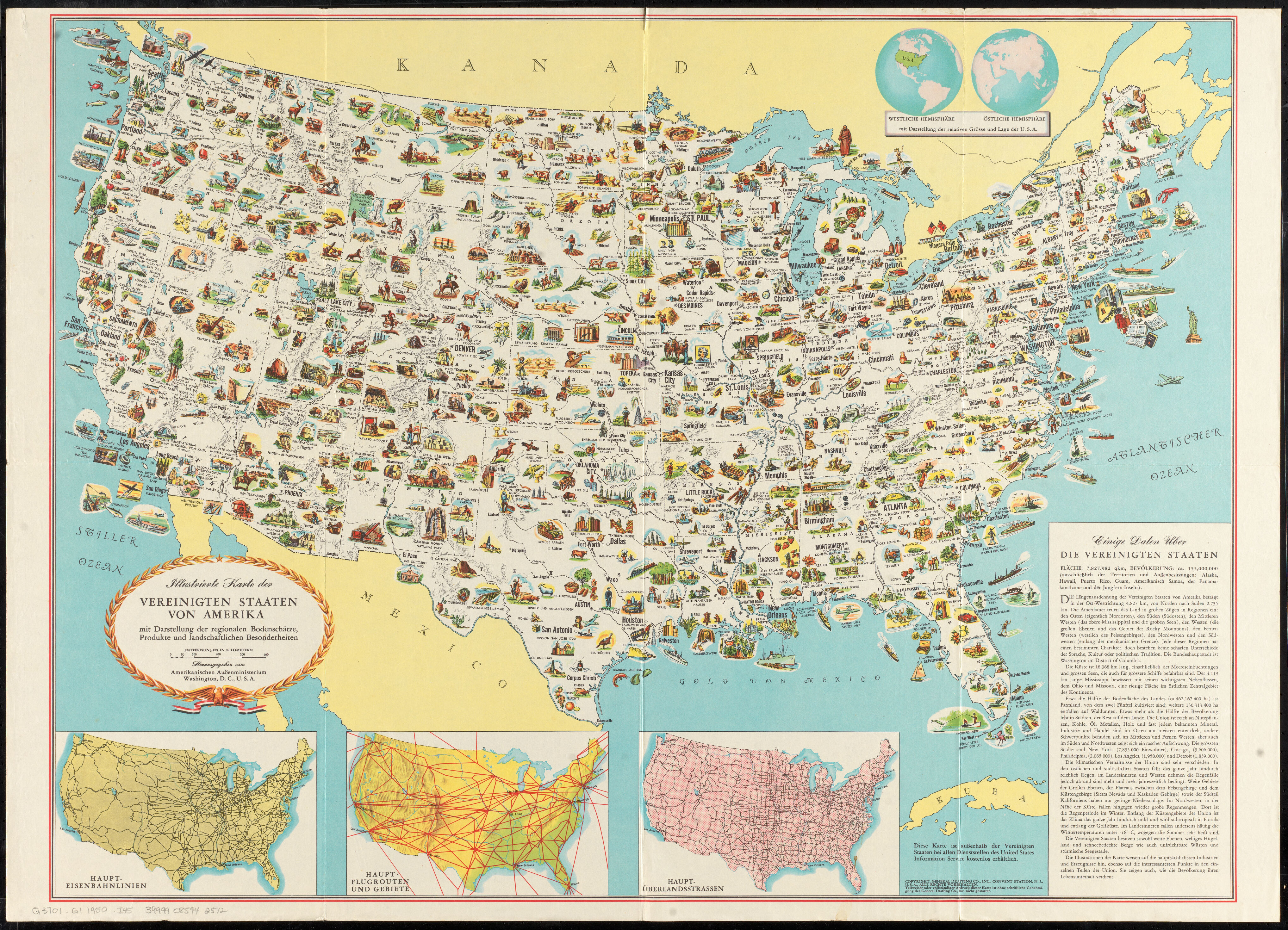
Illustrierte karte der Vereinigten Staaten von Amerika, from LMEC collections.
In the summer of 1942, the Roosevelt administration established the Office of War Information (OWI), a pro-war propaganda agency that operated both within the U.S. and abroad. Some of its creations are especially recognizable; the familiar Norman Rockwell poster below, sponsored by the OWI, calls on Americans at home to support the war effort abroad through the purchase of bonds. Overseas, the OWI’s goals included the management of the Voice of America, a U.S. state-owned radio broadcaster modelled on the wartime operations of the BBC.
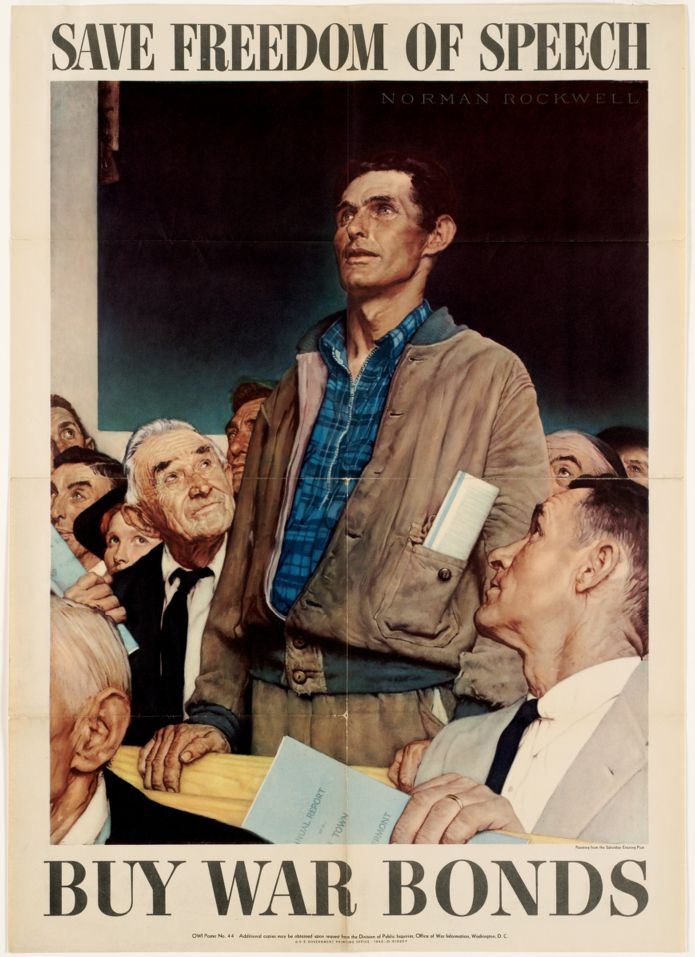
Save freedom of speech. Buy war bonds, from BPL collections.
After the War, the Truman administration disbanded the OWI, replacing it with a new ad-hoc propaganda department called the United States Information Service (USIS). The Smith-Mundt Act of 1948 authorized the first peacetime American propaganda operation to “present a ‘full and fair picture’ of the United States to the world at large,"[^1] and shortly after taking office in 1953, the Eisenhower administration would transform the somewhat informal USIS into the United States Information Agency.
Creating the Illustrierte karte
At the end of World War II, America’s economy was booming, but across the Atlantic, the majority of Europe found itself in dire straits. The United States had exited its long-held tradition of isolationism and wielded its newfound military superiority over the rest of the world, in particular Europe. The historian Rebecca Boehling writes that at the end of the War, much of Europe felt a need to relativize American military superiority, choosing to fall back on their understanding of America as a “culturally primitive, although technologically advanced, money-driven, amorphous, mass society."[^2] That effect was seen in particularly complex ways by the Germans.
Upon American occupation of West Germany post-War, it was seen as necessary for America to reshape the Germans' understanding of American society—as Boehling writes, American understanding was that all elements of German culture had played a role in the Nazification of the country, and new values needed to be instilled. The USIS was designed to reach into Europe, establishing libraries and creating publications with wide influence. The Illustrierte karte der Vereinigten Staaten von Amerika was one such tool for quietly exporting American ideologies.
The map, entirely in German, showcases key industries, landmarks or historical events in each U.S. state. In Massachusetts, Harvard and MIT are shown, situating Boston and Cambridge as an educational powerhouse, while Provincetown’s depiction of an artist at an easel foreshadows its durable status as an hub for the arts. In other states, local industries are highlighted, with cotton (baumwolle) and coal(kohle) appearing prominently in Alabama; silver mining (silber-bergbau) and cattle(rinder) in Nevada; and wheat (weizen) and rye barley (roggen gerste) farming in North Dakota.
A war of ideology
This map was likely one of USIS' publications distributed in a Cold War-divided Germany, claiming, as the Smith-Mundt Act intended, to provide a “full and fair picture” of the United States to the world at large. Of course, what was “full and fair” to the United States at this time was inflected with a great deal of political ideology. To the bottom right, the map provides factual information about the US, emphasizing that regional differences are less important than the common links that unite people across them. One passage in particular is quite striking:
The Americans divide the country roughly in regions: the East, the South (Southeastern), the Midwest (between the Mississippi and the Great Lakes), the West (the Great Plains and the Rocky Mountains), the Far West (west of the Rockies), and the Northwest and Southwest (along the Mexican border). All of the regions have a unique character, but do not have sharp differences in language, culture, or political traditions.
Since the Cold War was a war of ideology, propaganda was an effective tool for anyone interested in pushing their idea of the right way to do things. The Soviet Union, throughout its existence, used propaganda to promote its ideas about communism. In much the same way, the Illustrierte karte presents an idealized image of America, a United States that was built on a shared set of principles and truly united in every sense of the word—despite the reality that the regions displayed as lacking “sharp differences in language, culture, or political traditions” certainly did experience real differentiation in all three registers.
Similar maps were made in other languages including Spanish, Japanese, Farsi, and Russian, and distributed to countries that America wished to target with the image. The common thread? Countries that the American state was worried might turn their backs on capitalism and embrace Soviet ideas. Maps of this kind are significant in showing us the great lengths to which the U.S. went in order not just to represent but actively create a vision of America for the rest of the world, exactly the way the government of the day wanted it to be perceived.
Footnotes:
[^1]: Leo Bogart and Agnes Bogart. Cool Words, Cold War: A New Look at USIA’s Premises for Propaganda. (American University Press, 1995).
[^2]: Rebecca Boehling. “Commentary: The Role of Culture in American Relations with Europe: The Case of the United States’s Occupation of Germany.” Diplomatic History 23, no. 1 (1999): 57–69. http://www.jstor.org/stable/24913691.
Our articles are always free
You’ll never hit a paywall or be asked to subscribe to read our free articles. No matter who you are, our articles are free to read—in class, at home, on the train, or wherever you like. In fact, you can even reuse them under a Creative Commons CC BY-ND 2.0 license.