This is the fourth in a series of Map Chats commissioned by Richard Pegg, Director and Curator of the MacLean Collection in Illinois. This Map Chat is written by Mirela Altic during a fellowship at the MacLean Collection.
A map of the Amazon long thought to be lost has been found in the MacLean Collection Map Library. This manuscript map of the Amazon region was made in 1755 by Anselm Franz Eckart (1721--1809) after a map compiled by János Nepomuk Szluha (1723--1803) in 1753.
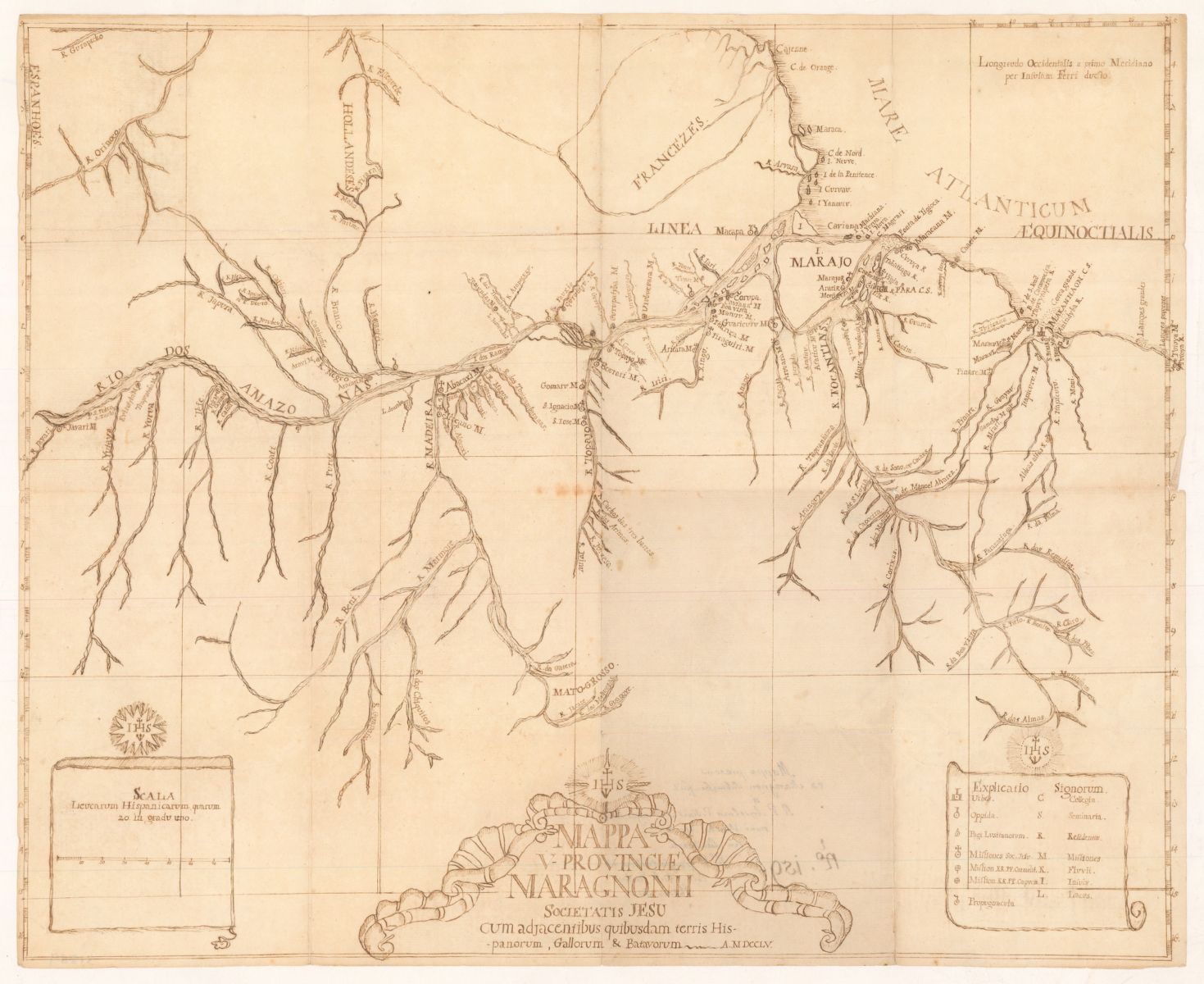
Aselm Eckart, Map of the Amazon (1755). MacLean Collection, MC 9222
Treaty of Madrid
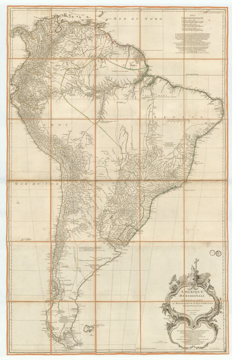
Jean Baptiste Bourguignon d'Anville, Amérique Méridionale (1748) MacLean Collection MC 22938
In 1750, Spain and Portugal signed the Treaty of Madrid, which assigned a large territorial expansion to Portugal. This area, later to become the northern borderland of Brazil, included the Amazon River valley.
As part of the negotiations, a Mapa das Cortes was created in Lisbon in 1749, under the direction of Alexandre de Gusmão (1695--1753), a Brazilian diplomat and private secretary of King João V of Portugal. Gusmão was known for his crucial role in the negotiations. The Mapa das Cortes was a compilation based on numerous sources of Portuguese, French and Spanish origin, among which Jean Baptiste Bourguignon d'Anville's (1697-1782) Carte de l'Amérique Méridionale (1748) played a major role.
D'Anville was a French geographer and cartographer. He had become the king's geographer at age twenty-two, and utilized the extensive surveys of members of the Society of Jesus (Jesuits) for his maps. His 1748 map is part of a two-part set of maps of North and South America. The future inverted triangular shape and relatively unknown interior of Brazil is easily distinguished. Looking in more detail at the map, one can see the extensive network of tributaries that make up the Amazon River Valley.
Detail of the Amazon River valley in d'Anville's 1748 map
The Mapa das Cortes, although it played a major role in the negotiations, was not sufficiently detailed for demarcating the most contentious parts of the border. It was clear that new maps based on field observation would be essential instruments, especially for the little-known but potentially economically lucrative area of the Amazon. Soon after the Treaty of Madrid was signed, the Portuguese King José I (who took the throne after João V's death in July 1750) began recruiting Jesuit cartographers.
These Jesuits were vital to carrying out cartographic activities for the purpose of administering the empire, and would be sent to Brazil to help demarcate the new borders of the Portuguese possessions. Portuguese mapping of the Amazon, essentially beginning in 1752, was a particularly difficult task not only because of the demanding terrain, but also because of the lack of reliable existing Portuguese maps of the region.
Jesuits in the Amazon
The first significant Portuguese effort to map the region was begun around 1752 by Jesuit missionairies who were serving along the Xingu and Tapajós rivers. Particularly significant was the German Jesuit Lorenz Wilhelm Kaulen, who, while serving in missions along the Xingu River around this time, produced a map showing the flow of the Xingu and Tapajós rivers. A Hungarian Jesuit serving in the Portuguese service, János Nepomuk Szluha (1723--1803), also worked on the reconnaissance of the entire Amazon and its tributaries.
Szluha was a distinguished mathematician, astronomer, and cartographer. From 1753--1759, he worked as a missionary on the Pinaré River (the Province of Maranhão) and taught at the Jesuit College of Belém do Pará. In 1753 Szluha drafted a map of the Jesuit Vice-Province of Marañón which showed the spatial scope of the Portuguese missions in the Amazon region, a map preserved today in the Library of Evora (Portugal). In 1755, Anselm Franz Eckart, a Jesuit who had arrived in the region in 1753, made a manuscript copy of Szluha's 1753 map, and noted this copy in his journals.
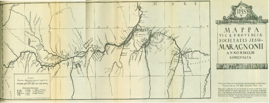
Facsimile map by Johann Nepomuk Szluha compiled in 1753, showing the misattribution assigned by Leite in 1943
Because Szhula's 1753 map was unsigned it had long been misattributed as the work of Kaulen. In 1943, the Portuguese historian Serafim Leite (1890--1969) confused Kaulen's 1752 map of the Xingu and Tapajós with the map of the Amazon by Szluha compiled in 1753. Leite even published a supposed facsimile of Szluha's 1753 Amazon map but attributed the map to Kaulen.
The confusion over authorship of the map can now, however, be resolved thanks to the rediscovered manuscript map in the MacLean Collection that was rendered by Szluha's contemporary, Anselm Franz Eckart. According to Eckart's notes, he made his manuscript copy of Szluha's 1753 map in 1755. This date confirms Szluza's authorship of the unsigned map in the Library of Evora.
Anselm Eckart's Map of the Amazon
In Eckart's Map of the Amazon, the importance of the Society of Jesus is particularly notable in the close attention to Jesuit iconography and infrastructure in the Amazon area and in the title cartouche.
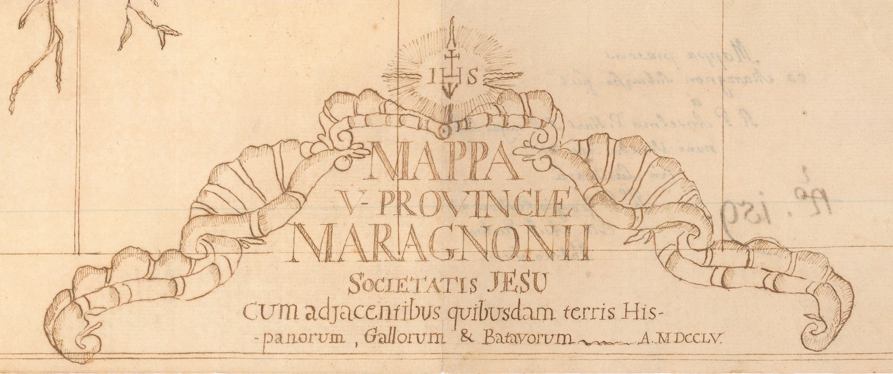
Title detail in Eckart's 1755 map
The title border depicts shells topped by the Jesuit star and the figure "IHS," a Christogram for the name Jesus. The title of the map translates in English as "Map of the Vice Province of Maragnonii, Society of Jesus, with some adjacent territories of the Spanish, Gauls (English) and the Dutch."
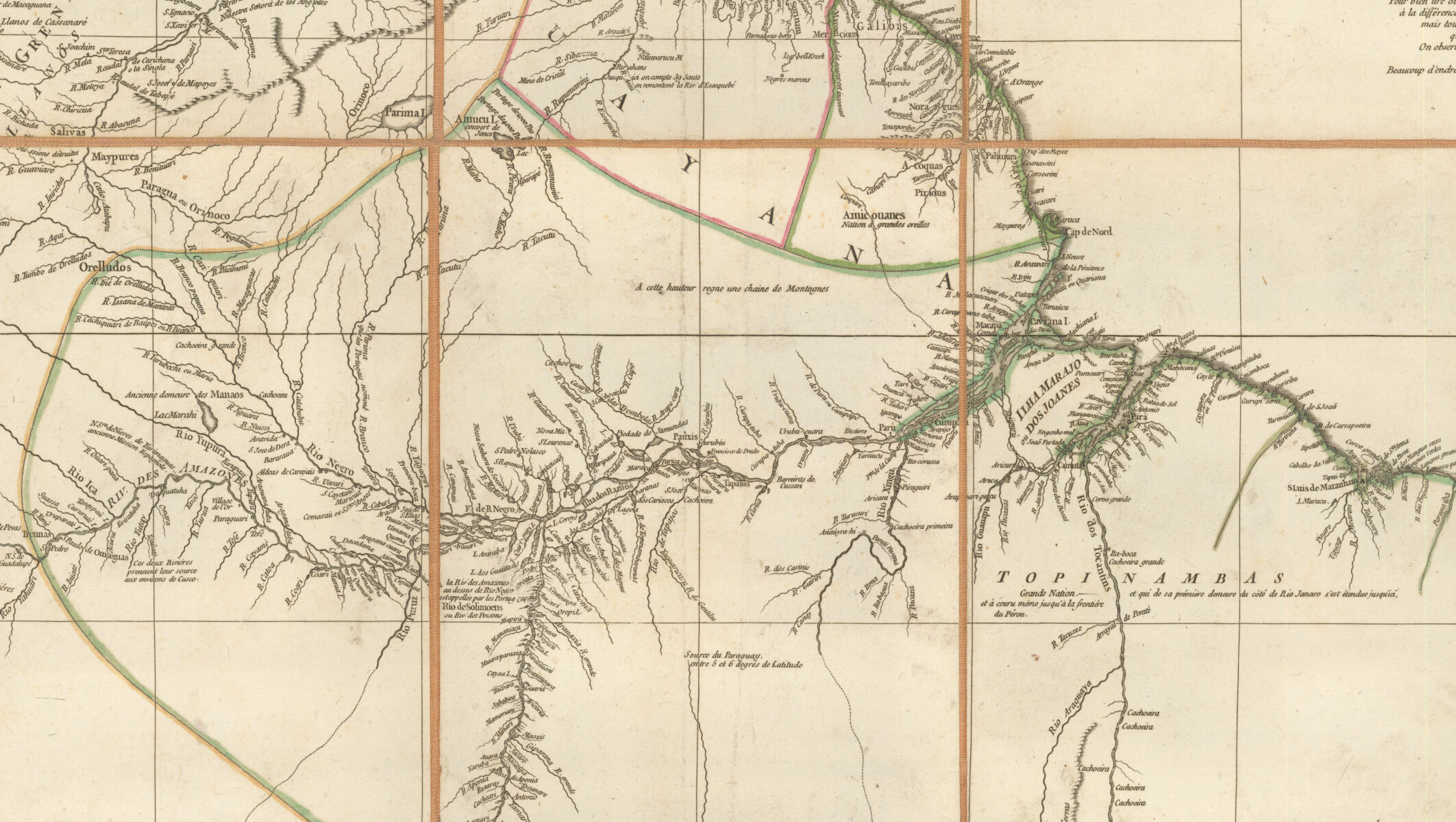
In addition to Jesuit missions, Eckart intentionally highlighted the extensive presence of the Society of Jesus and their central role in maintaining colonial power in this remote place. The map key is also topped with the insignia of the Society of Jesus and includes symbols for towns and villages, Portuguese settlements, Jesuit and Carmelite missions, and forts as well as capital letters indicating colleges, seminaries, residences, missions, rivers, islands and lakes. This detail of the Xingu River clearly shows the use of these symbols and capital letters.
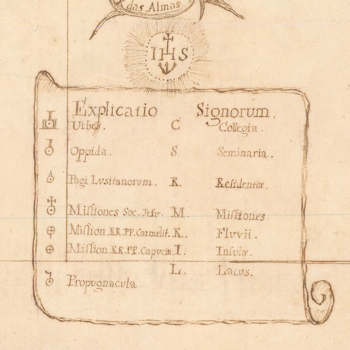
Details of the key in Eckart's 1755 map
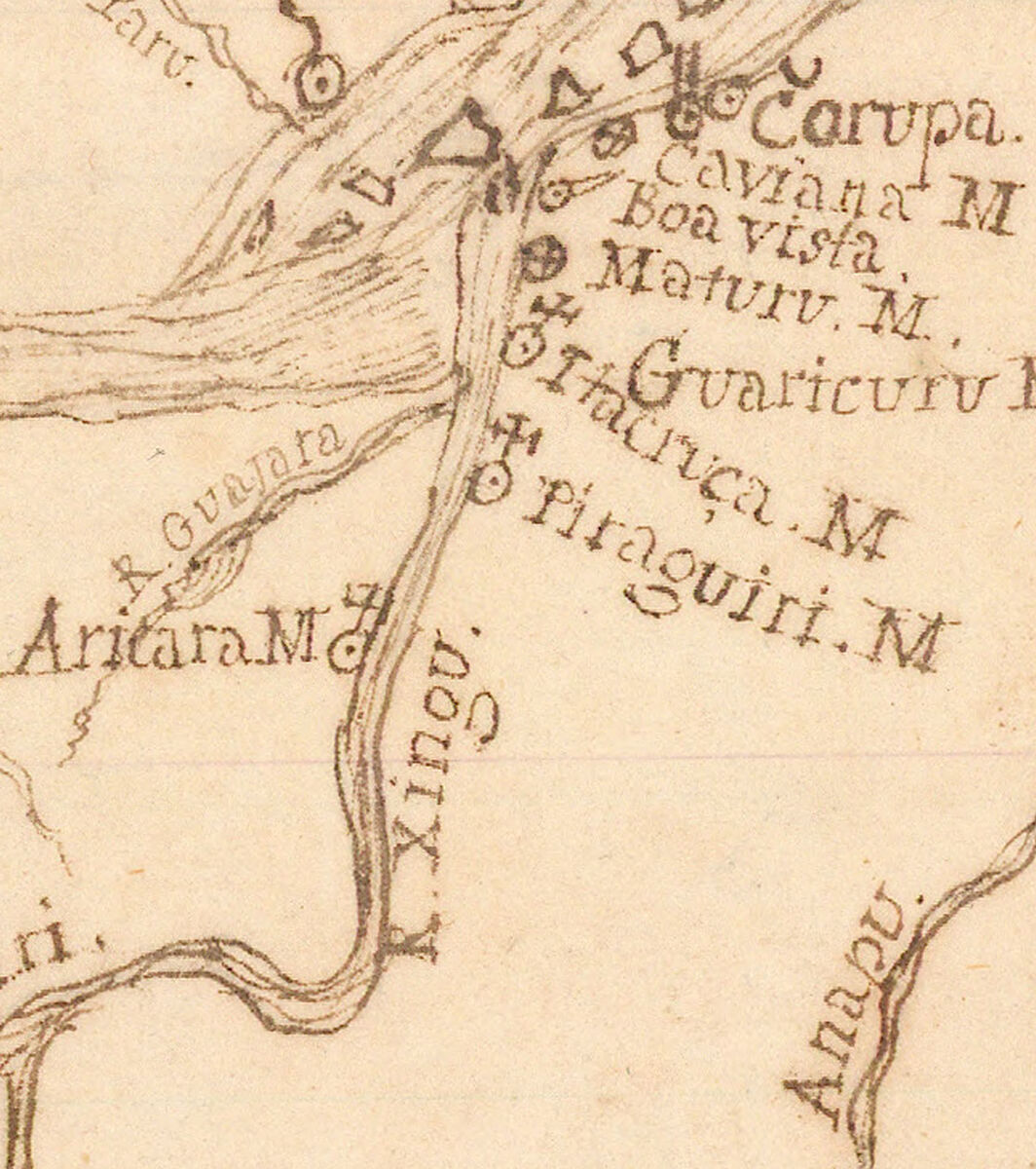
Detail of the Xingu River
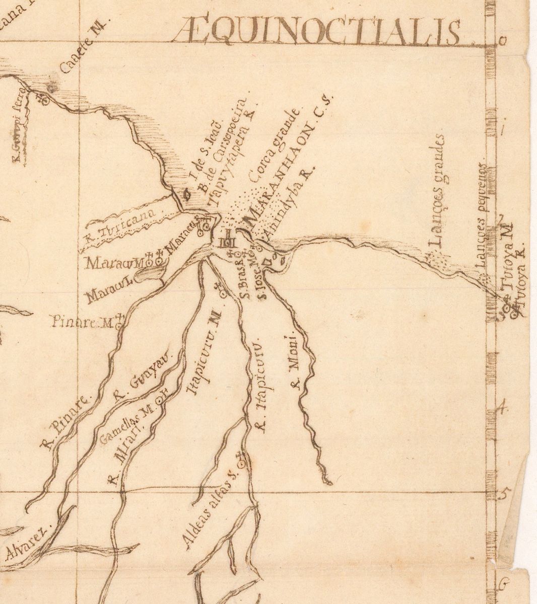
Detail of the Pinaré River valley
The map is north-oriented and accompanied by a graticule of longitude (east of Ferro) and latitude with a scale (approximately 1:3,000,000). Although the map is undoubtedly based on original observations, its references to cartographic predecessors like d'Anville's Carte de lʼAmérique Méridionale are clearly visible, especially in the presentation of the main course of the Amazon as well of its southern tributaries. Significant new information on the map is evident in the area around the Pinaré River where Szluha served as a missionary.
Given that Szluha also made significant contributions in the mapping of the Xingu and Tapajós rivers, it is likely that he incorporated Kaulen's data into his map as well.
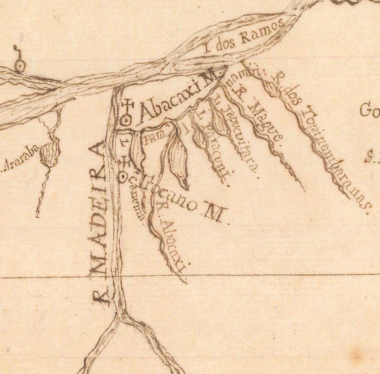
Madeira River detail
The importance of the Jesuit presence in the Amazon region during the mid-eighteenth century for numerous mapping projects is underscored by maps like Eckart's. Although they represented important steps forward in the European reconnaissance of the Amazon and in the marking of Portuguese possessions in that region, the maps of Kaulen, Szluha and Eckert only confirmed the growing need of imperial administrators to conduct a thorough scientific survey of the entire region on a larger scale.
The colonial government demanded a new, more detailed map that would more precisely demarcate the northern border of Brazil. It would soon appear after the Portuguese demarcation commission led by Francisco Xavier de Mendonça (1701--1769) completed a survey in 1755, resulting in the first hydrographic map of the Amazon River.
Mirela Altic is a professor of history and lectures on map history and historical geography at the University of Zagreb, Croatia. Over the last decade she has published extensively on the explorative and missionary cartography of the New World. In 2019, she was a MacLean Collection Map Fellow. Her latest book Encounters in the New World: Jesuit Cartography of the Americas, scheduled to be published by the University of Chicago Press in early 2022, is based in and supported by the MacLean Collection.
References
Mirela Altic, "Missionary Cartography of the Amazon after the Treaty of Madrid (1750): A Jesuit's Contribution to the Demarcation of Imperial Frontiers." Terrae Incognitae 46 (no. 2, 2014): 69--85.
Júnia Ferreira Furtado, Oráculos da Geografia iluminista: Dom Luís da Cunha e Jean-Baptiste Bourguignon D'Anville na construção da cartografia do Brasil (Belo Horizonte: UFMG, 2012).
Júnia Ferreira Furtado, The Map that Invented Brazil. (São Paulo: Versal Editores for the Fundação Odebrecht, 2013).
Serafim Leite, História da Companhia de Jesus no Brasil, 10 vols. (Rio de Janeiro: Livraria Portugália, 1938--1950).
Marcos Carneiro de Mendonça, ed., A Amazônia na era Pombalina. Correspondência Inédita do Governador ... Francisco Xavier de Mendonça Furtado 1751--1759, 3 vols. (Rio de Janeiro: Instituto Histórico Geográfico Brasileiro, 1963).
Johannes Meier and Fernando Amado Aymoré, Jesuiten aus Zentraleuropa in Portugiesisch und Spanisch-Amerika. Band 1: Brasilien (1618--1760). (Münster: Aschendorff Verlag, 2005).
Our articles are always free
You’ll never hit a paywall or be asked to subscribe to read our free articles. No matter who you are, our articles are free to read—in class, at home, on the train, or wherever you like. In fact, you can even reuse them under a Creative Commons CC BY-ND 2.0 license.