This article features objects from our upcoming exhibition on environmental justice, More or Less in Common, opening March 18. We can't wait to see you there!
What's that smell?
Here's a riddle for you. What has no shape, takes no form, and greatly impacts our experiences of urban space?
Is it sunlight? Noise? Greenhouse gas emissions? Yes, yes, yes: all of these ephemeral qualities make for excellent answers (and they also feature prominently in our upcoming exhibition, More or Less in Common). They shape how we move through and engage with cities, even though we don't see, feel, or touch them in the same way we might touch the dirt in a park or the bricks on a building. Today, I want to focus on one of these ephemeral qualities in particular: smell.
Urban geographers and historians have spilled a good bit of ink documenting the smell of cities. For example, bad smells impacted property values, public perception, and urban growth in "animal suburbs" like Brighton, where the "inexpressibly offensive" odors of the Brighton Abbatoir frequently riled up citizens and the Board of Health.
Bad smells were apparently so problematic in a number of Boston neighborhoods that, in 1878, the Board of Health deemed them worthy to be mapped:
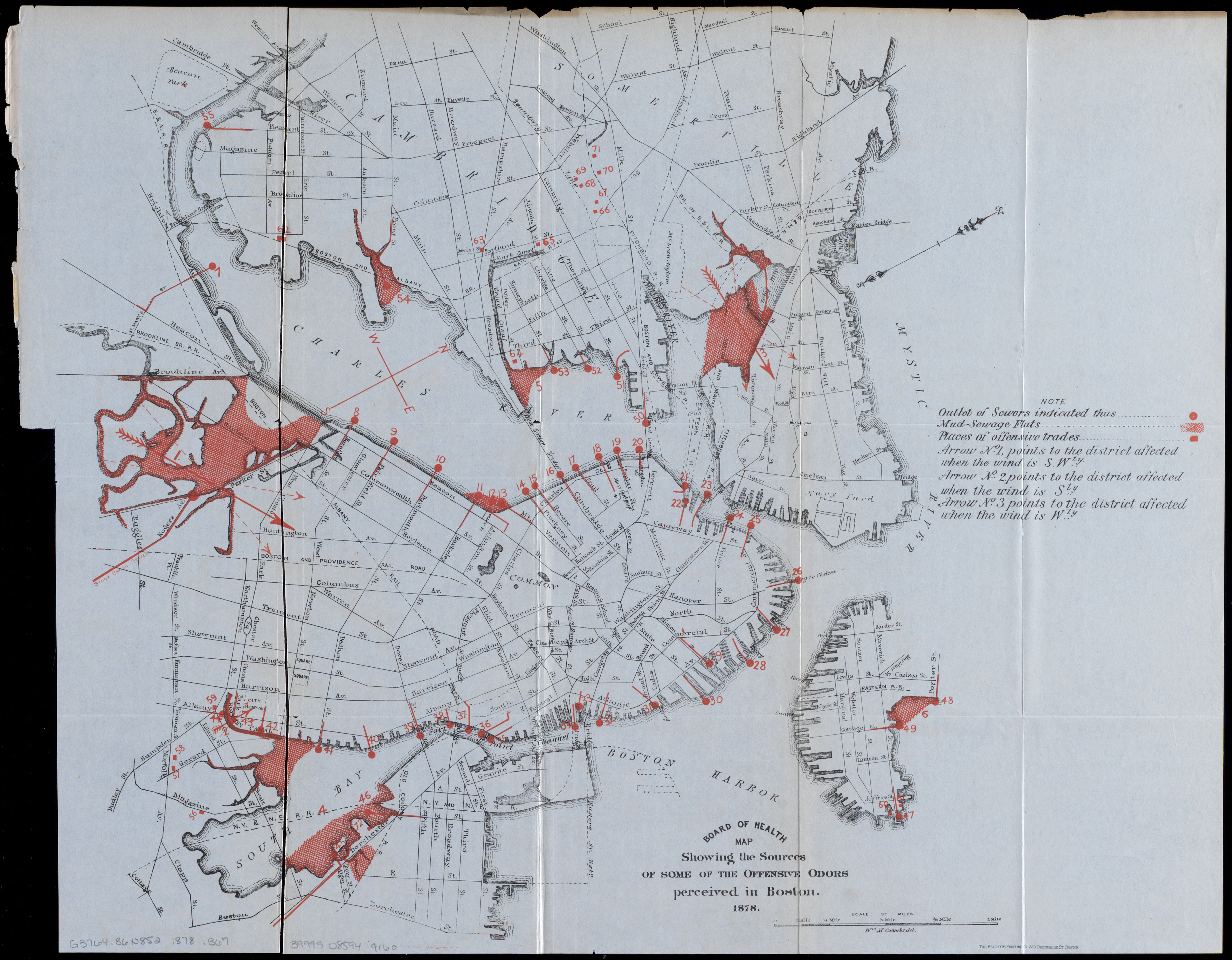
1878 Board of Health map depicting "offensive odors." Featured in More or Less in Common.
Let's do some sniffing around: what can this map teach us about ecological change, environmental perception, and urban form near the turn of the 20th century?
A case of "bad air"
Shading them in red, the 1878 Board of Health map identifies three sources of "offensive odors," including sewer outlets, mud-sewage flats, and "places of offensive trades" (like this one in Cambridge, possibly a tallow factory). The geography of these smells was not merely incidental; Boston, of course, was originally located on an island connected to land by a narrow peninsula. Its surrounding salt marshes quickly became a dumping ground for trash, sewage, and toxic industries like tanneries. As residential areas were built on newly-filled neighborhoods in the flats, the “offensive odors” of these defiled landscapes became a problem. One engineer describedthe basin where Stony Brook met Muddy Riveras "the filthiest marsh and mud flats to be found anywhere in Massachusetts... a body of water so foul that even clams and eels cannot live in it, and that no one will go within half a mile of in summer unless from necessity, so great is the stench arising therefrom.”1
You might wonder why the Board of Health was responsible for geographically documenting such odors in the first place. At this time, most American physicians accepted the “miasma theory” of disease, which stated that sicknesses like cholera and chlamydia spread through “bad air.” For example, this map of an 1849 cholera outbreak in Boston accompanied a report that blamed overcrowding and poor ventilation---rather than germs in contaminated water---for the outbreak.
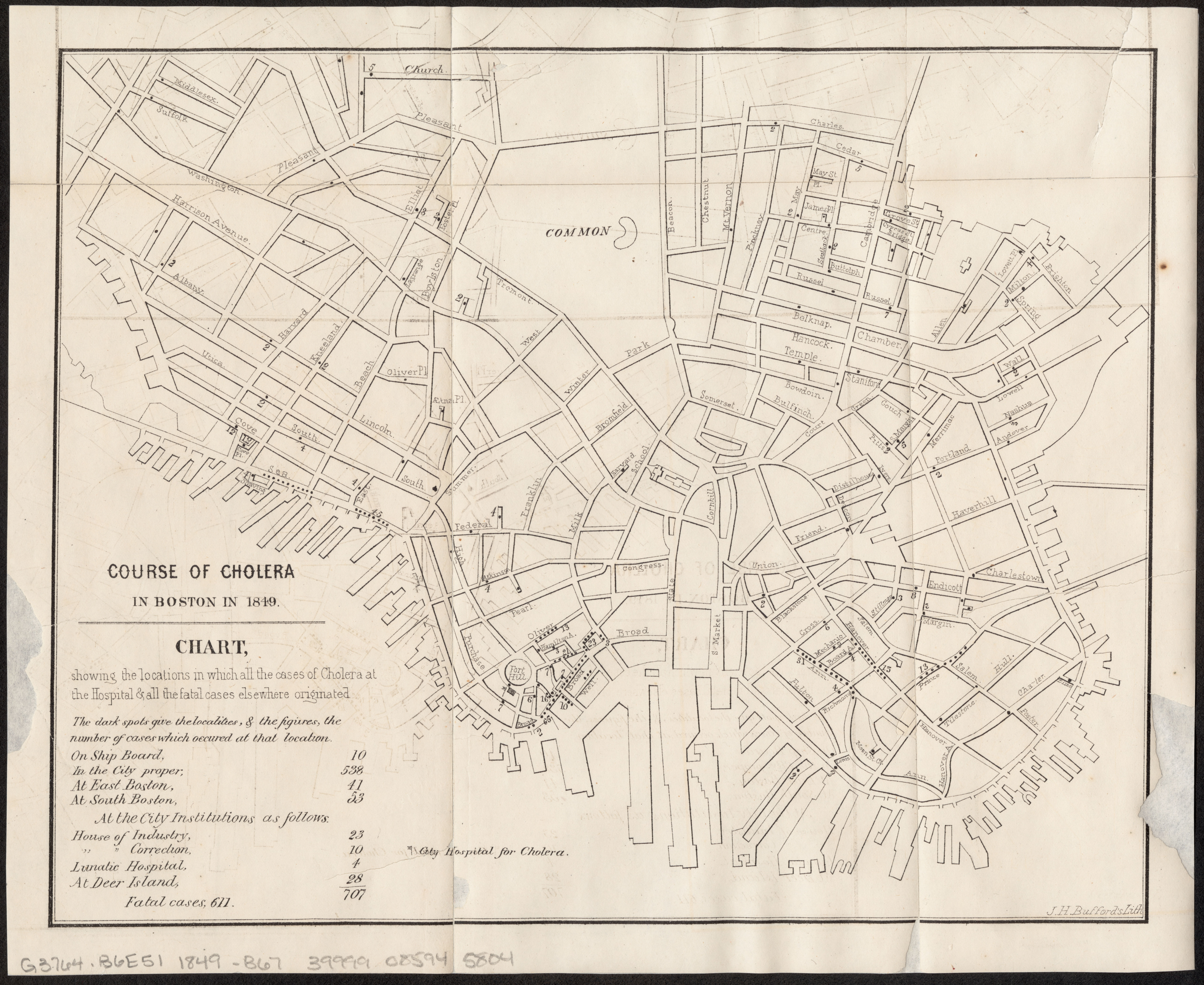
From our collections, this 1866 map depicts an 1849 cholera outbreak in Boston.
In this case, the Fort Hill tenements to which many cholera cases were traced were occupied predominantly by Irish immigrants. Since anti-immigration advocates already viewed immigrants as unsanitary and intemperate, the miasma theory also provided a convenient medical justification---erroneous though it was---for their pre-existing racist attitudes and beliefs.
From "offensive odors" to "ornamental esplanades"
Less than ten years later, in 1886, that very same mud-sewage flat in the Back Bay was unrecognizable. In this map of "New Boston and Charles River Bay," it is depicted as an “ornamental esplanade,” resplendent with greenery, “costly buildings,” and well-dressed pedestrians.
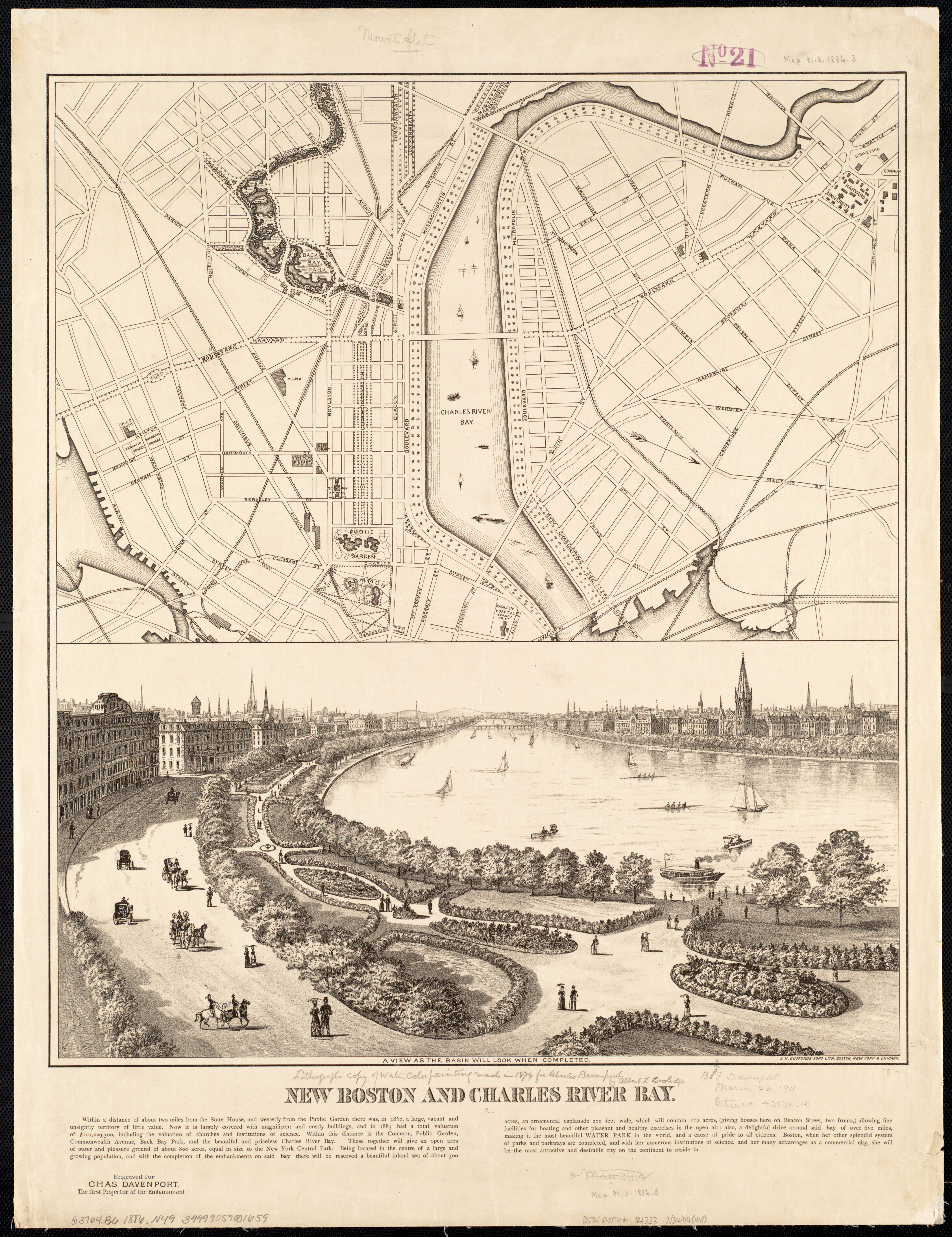
From our collections, this 1886 map and view shows recent renovations to the Back Bay area, including "view as the basin will look
What used to be labelled “offensive odors” has been transformed into “Back Bay Park.” We know it today as the Back Bay Fens because Frederick Law Olmsted---a key landscape architect on the project---insisted that it not be called a “park,” since the renovation was not for recreational but primarily sanitary purposes.
As we discuss in our upcoming exhibition More or Less in Common, these sanitary improvements are examples of the complex entanglements between humans and nature. Environmental reforms like the development of the Back Bay Fens were inspired not only by a dawning recognition of human-led ecological challenges, but also by an attempt to regulate the “moral” character of the city. Clean, tidy neighborhoods well-served by sanitary infrastructure were seen as necessities for a bourgeois vision of domestic order. All were of the utmost importance to make Boston, to quote the map, "the most attractive and desirable city on the continent to reside in."
Be sure to visit the LMEC’s upcoming exhibition More or Less in Common, beginning on March 18, to learn more about the geographies of environmental justice!
1. From page 215 of Nancy Seasholes' Gaining Ground.
Our articles are always free
You’ll never hit a paywall or be asked to subscribe to read our free articles. No matter who you are, our articles are free to read—in class, at home, on the train, or wherever you like. In fact, you can even reuse them under a Creative Commons CC BY-ND 2.0 license.