We’re excited to welcome Micaela Kahn to the team as the Fall 2023 co-op student serving as Visitor Services & Exhibition Assistant. Mica is a student at Northeastern University studying Cultural Anthropology and Media & Screen Studies and will be working at the Leventhal Center until December 2023. We sat down with Mica to learn more about her interests and work on upcoming Leventhal Center exhibitions.
Tell us a bit about your background. What are you currently studying at Northeastern and what made you choose to work at the Leventhal Center during your co-op experience?
I grew up in Massachusetts and have been enjoying living in Boston since the start of my Northeastern career. I am studying cultural anthropology and have just finished my minor in media and screen studies. I was drawn to the LMEC co-op position by the prospect of working with the public and by the opportunity to develop my research and interpretation skills. I have always been interested in the humanities, the social sciences, and visual media. I love the way each map contains its own narrative which is influenced by several factors, principally the biases and worldviews of the cartographer(s); even maps that might seem to be matter-of-fact, like a map of a neighborhood block or a railroad. On that note, something that is really interesting to me is how maps can play a pivotal role in shaping the world around us, a fact that has proven true for both better and worse over the course of history. The practice of redlining comes to mind as one powerful example of how humans directly shape maps, which mutually influence our world. Such issues of equity and justice will be prominent in our upcoming exhibit, Getting Around Town: Four Centuries of Boston in Transit. I think an exhibition centered on Boston transit is a great lens through which we can draw attention to the larger issues that exist here, allowing visitors to make connections between seemingly disparate aspects of Boston’s history, like the connection of practices such as redlining to Boston’s current state of transit justice.
What’s your earliest memory of looking at/working with maps?
I love this question! Probably the maps inside fantasy novels or movies like the Indiana Jones film series. It has only been recently, though, that I have improved my map reading and interpreting skills; my academic studies have led me to really enjoy the process of decoding such texts. I find that even maps that present as simple in design can be really fun to interpret, and I often spend longer than I expected looking at them.
You’re starting in the middle of the run of Building Blocks, which is based on the same fire insurance and real estate atlases that form Atlascope. Have you discovered anything fun on Atlascope?
Atlascope is awesome for so many reasons. The feature that allows you to find location-specific photographs through the Digital Commonwealth is so cool! My favorite part of Atlascope, though, is what patrons have been using it for. I particularly love how people use Atlascope to connect with others and their own history. People ask me to search the Boston addresses of where their family members lived a few generations back, or they ask to see what their current apartment building looked like over 100 years ago, hoping to situate themselves in a larger context and history. It reminds me a little bit of the act of thrifting clothing or shopping for antiques: when you buy an antique piece of decor, for example, that piece had a place in someone else life, one that you now have a relation to by including this piece in your own life. A connection, one which often spans several generations, is forged between people who have never met. I think using Atlascope in this manner creates a beautiful moment of human connection, and I am glad to help make those moments happen in the gallery.
What are you excited about working on in the next six months?
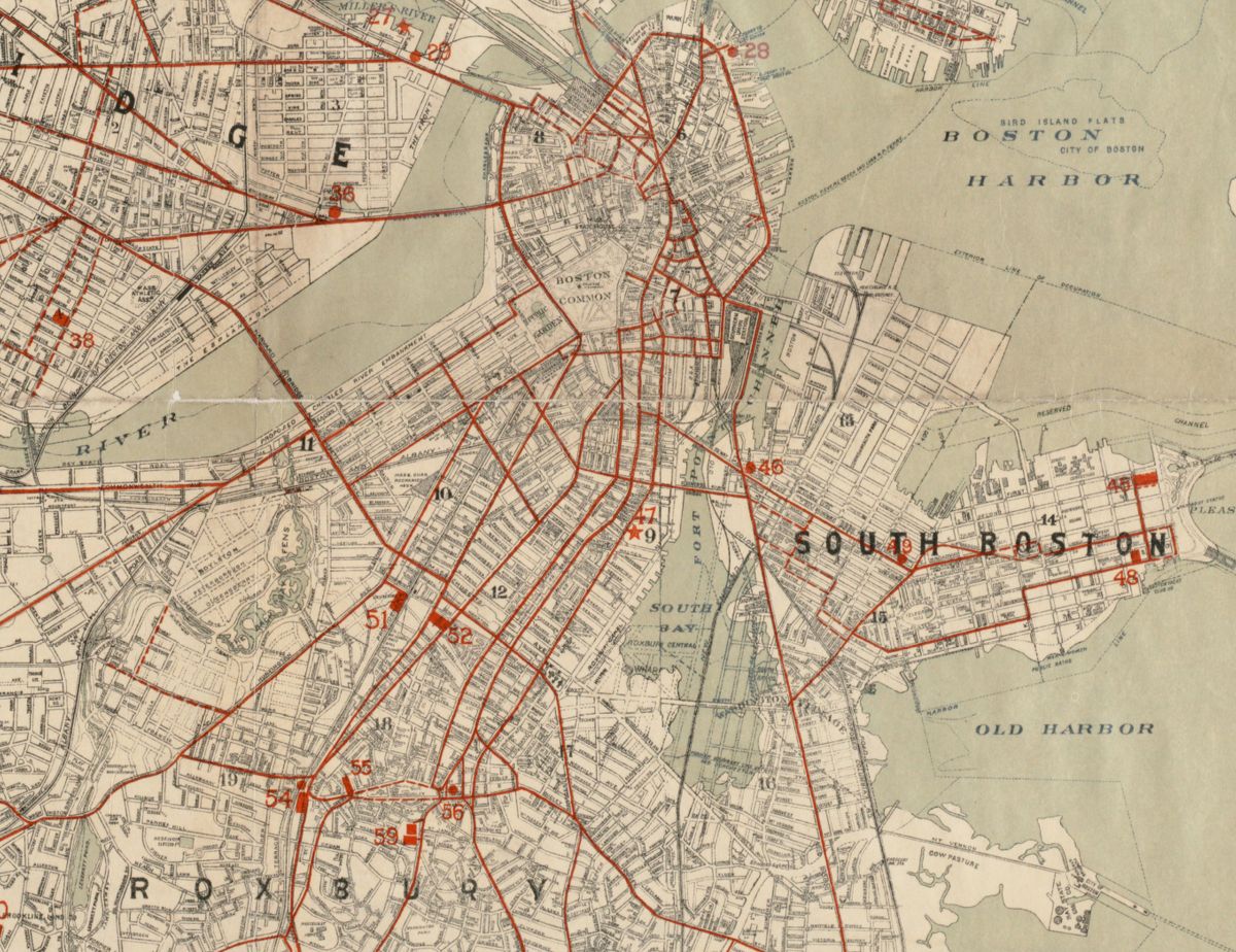
Detail of the Map of Boston and vicinity showing tracks operated by the Boston Elevated Railway Co., surface lines 1898
I am very excited to apply the skills and modes of thinking I’ve learned as an anthropology student to my work with maps — specifically diving into questions such as: what meanings are encoded in this map? What impact does said map have on the community or space it represents? If an older map, what impact did it have at its time of publishing? Can any negative effects of the said map be remedied? What can this map teach us about a specific time/place/event, and how do we move forward from here? Broadly, I am very excited to investigate what maps can tell us about social and geographic forces acting upon one another, as well as how maps can aid and enrich public education, changing our world for the better along the way. More specifically, I am excited to help ring in the new exhibit in September, Getting Around Town. I am so thrilled to be a part of the LMEC mission to highlight to the public maps as fun, accessible, and rich texts through which much can be learned, and connections between people and the world around them can be forged.
I know you’ve only just gotten here, but do you have a favorite map in the LMEC collections?
This is a tough question, given the great number of maps in the LMEC collections. However, one that I keep coming across recently is the 1781 map Eight views of the east of Nova Scotia from Joseph F.W. Des Barres. I really like this one! I will admit, a large part of the reason I like it is because it has aesthetic value (see: cute little boats in the views). However, I am also fascinated and impressed by the fact that these headland views could be used by mariners to accurately navigate the Nova Scotia coastline.
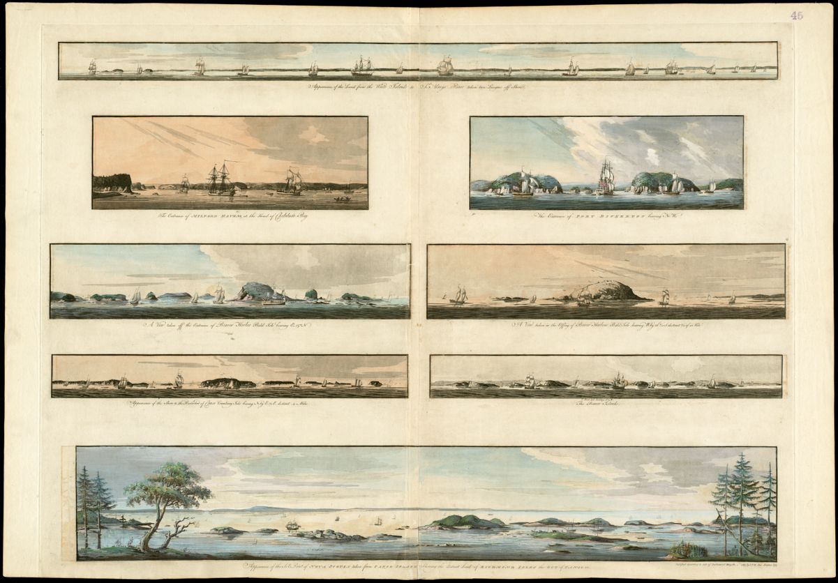
The 1781 map from Joseph F.W. Des Barres entitled Eight views of the east of Nova Scotia was part of a larger volume called Atlantic Neptune.
Our articles are always free
You’ll never hit a paywall or be asked to subscribe to read our free articles. No matter who you are, our articles are free to read—in class, at home, on the train, or wherever you like. In fact, you can even reuse them under a Creative Commons CC BY-ND 2.0 license.