On February 15, we hosted From The Vault: Literary Landscapes! From The Vault is a biweekly event series showing collections objects selected by Leventhal Center staff. For this edition of the series, we explored the worlds of some of the most iconic landscapes of storytelling! From Sherlock Holmes to Winnie the Pooh, we examined the ways literature uses maps to strengthen the impact of storytelling.
Bernard Sleigh, An Anciente Mappe of Fairyland Newly Discovered and Set Forth (1917)
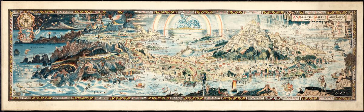
This map of Fairyland depicts places from nursery rhymes, fairy tales, Arthurian legends, and the folktales of many cultures. Sleigh, the cartographer, initially sketched a map of fairyland to entertain his children, adding characters and places from their favorite stories. This map was published in 1917 and intended to decorate nurseries. After Sleigh retired in 1937, the print was turned into a decorative fabric for Rosebank Fabrics. The print was so popular that Rosebank commissioned Sleigh to design other fairy tale patterns for fabrics.
Jaro Hess, The Land of Make Believe (1935)
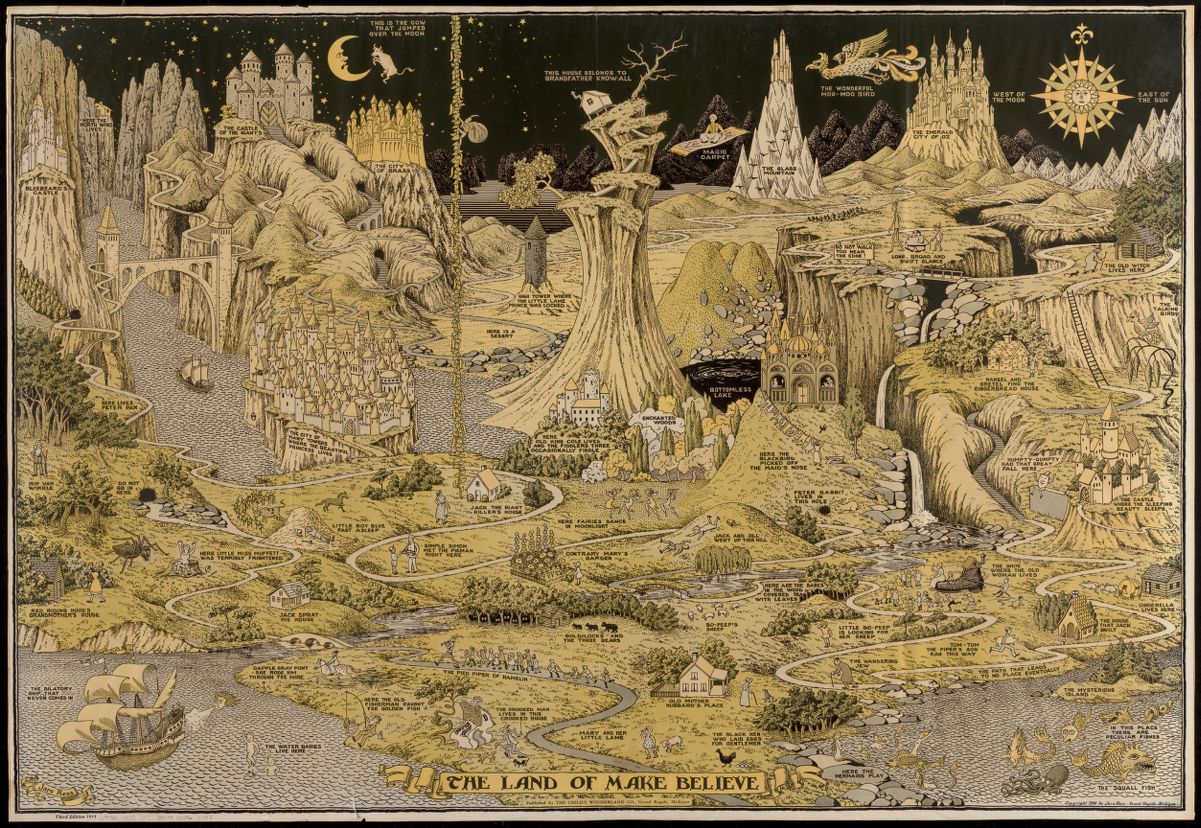
A bit more dark and mysterious than we usually think modern fairy tales to be, this fantasy map is populated by figures from nursery rhymes, fairy tales and children’s books circa the early 1900s. If you look closely, you can see Jack’s beanstalk reaching up to the sky, Little Red Riding Hood on her way to her grandmother’s, and Humpty Dumpty sitting very close to the edge of his wall…
William Gropper, William Gropper’s America, Its Folklore (1946)
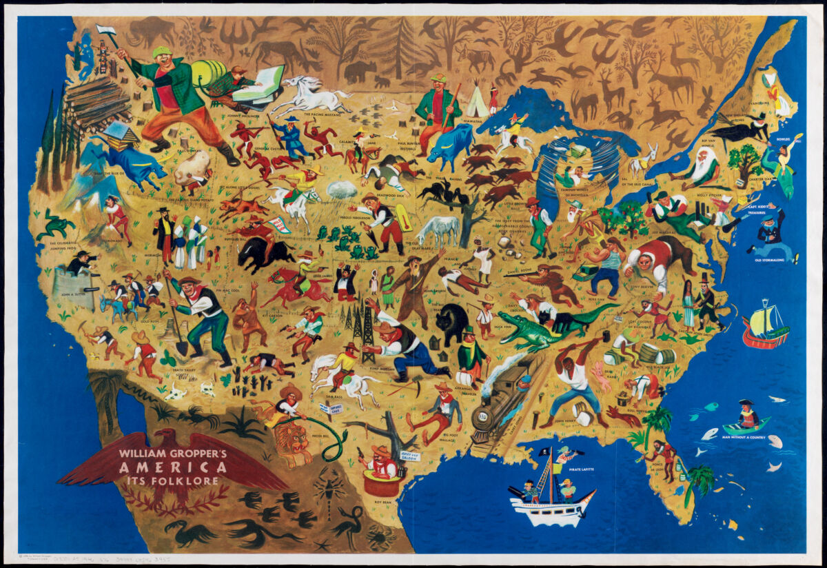
Folklore consists of legends, music, oral history, proverbs, jokes, popular beliefs, fairy tales, and stories that exemplify some part of the traditions or beliefs held by a culture, subculture, or group. This map specifically focuses on American folklore, of which some of the stories have been told since the European colonization of the Americas, and in some cases, even earlier. For a more detailed analysis of the map and cartographer, check out this article.
Try to spot Johnny Appleseed, John Henry, or Buffalo Bill!
Ruth Stiles Gannett, Map of the Island of Tangerina and Wild Island (c1948; reproduction, 2014)
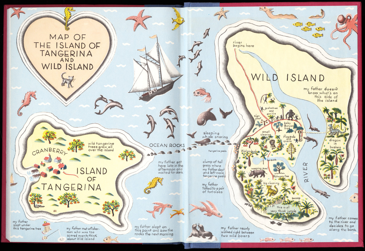
This map shows the path of Elmer, a young boy, on his quest to rescue a dragon in need. In the story My Father’s Dragon, a stray cat tells young Elmer Elevator about a baby dragon who is being forced to carry the lazy animals of Wild Island across a river, and Elmer makes it his quest to save the dragon. The map was drawn by the author’s stepmother, an illustrator of children’s books.
Jeremiah Benjamin Post, An Atlas of Fantasy (1973)
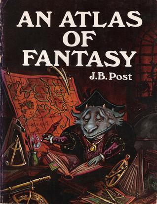
This atlas has a heavy emphasis on science fiction and fantasy, though Post did suggest at one point that there exist enough mystery fiction maps to someday create The Detectives' Handy Pocket Atlas. When first published, it was greatly received by the fantasy literature and game communities.
Molly Maguire, Designer; Jim Wolnick, Illustrator, The Sherlock Holmes Mystery Map (1987)
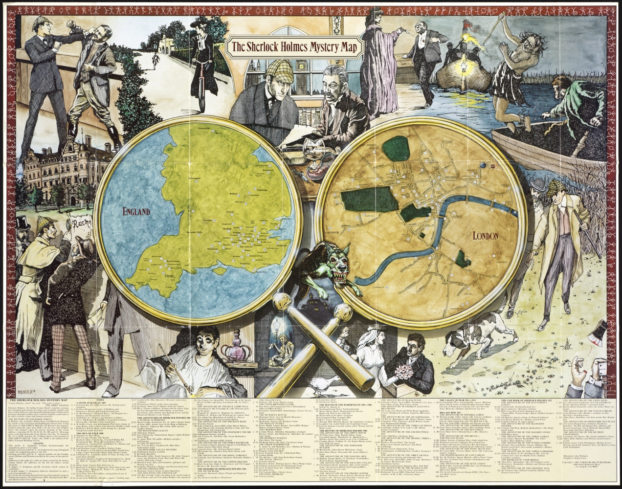
The adventures of Arthur Conan Doyle’s eccentric detective Sherlock Holmes are illustrated on this late 20th-century pictorial poster. Two magnifying glasses, containing maps of Victorian-era England and London, are numbered to identify locations associated with the Holmes stories. Illustrations from a number of tales surround the map, and feature characters such as Holmes’ loyal colleague Dr. John Watson, his adversary Professor Moriarty, and a vicious hound from The Hound of the Baskervilles.
Warner Bros. Entertainment, Messrs. Moony, Wormtail, Padfoot & Prongs Are Proud to Present the Marauder’s Map (2007)
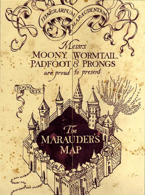
This map is from the iconic Harry Potter series and was created by the Marauders, a friend group consisting of Remus Lupin (Moony), Peter Pettigrew (Wormtail), Sirius Black III (Padfoot), and Harry’s father, James Potter I (Prongs). In the Harry Potter universe, the map shows every classroom, hallway, and corner of Hogwarts, as well as every inch of the grounds, including secret passages hidden within the walls and the location of every person in the grounds, portrayed by a set of footprints.
Ernest H. Shepard, Map of the 100-Acre Wood (2014)
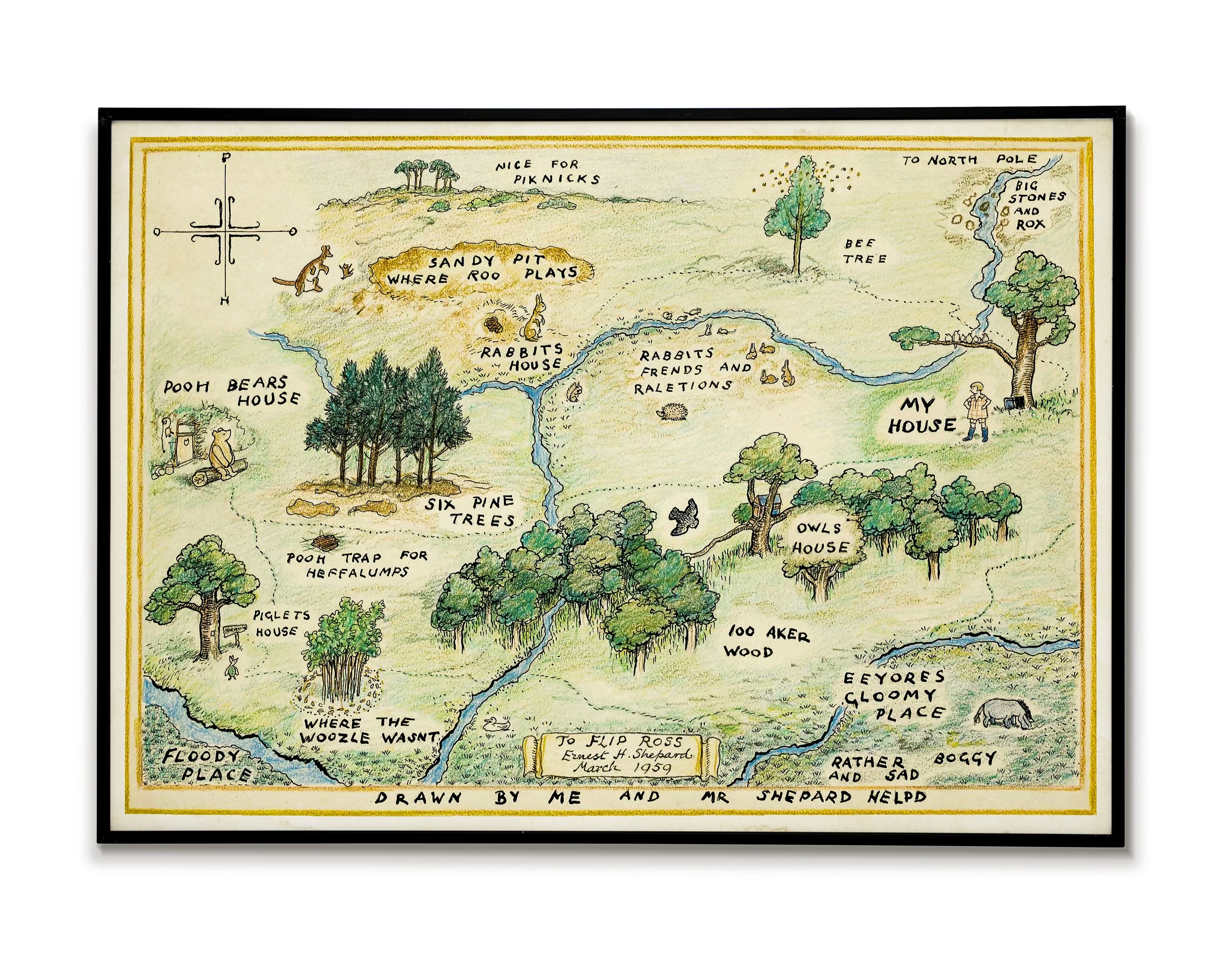
Christopher Robin, teddy bear Winnie-the-Pooh and other stuffed animals live in the 100-Acre Wood. The friends go on picnics, hunt heffalumps and have everyday adventures! This map shows Christopher Robin’s house, his friends’ houses, and places they explored. Christopher Robin notes that Mr. Shepard “helpd” him draw the map. E. H. Shepard, who illustrated the books, based Winnie-the-Pooh on his own son’s stuffed bear.
Our articles are always free
You’ll never hit a paywall or be asked to subscribe to read our free articles. No matter who you are, our articles are free to read—in class, at home, on the train, or wherever you like. In fact, you can even reuse them under a Creative Commons CC BY-ND 2.0 license.