On June 9, we hosted From The Vault: School’s Out! From The Vault is a biweekly event series showing collections objects selected by Map Center staff. For this edition the series, we looked at objects that were created for or within a school environment.
Nathaniel G. Huntington, The Common School Atlas (1836) and J. A. Cummings, School Atlas to Cummings' Ancient & Modern Geography (1821)
These two school atlases, The Common School Atlas and School Atlas to Cummings' Ancient & Modern Geography, were created in the early decades of the 19th century and provided visual aids in the form of maps to supplement geography textbooks. At this time, geography textbooks were constructed as catechisms – long passages of text from which the student was to read from then answer questions. Passages listed places and natural features such as mountains and rivers, and included illustrations to supplement geographical learning. This type of rote memorization was common in teaching methods of the time.

Laura A. Roys, Connecticut (1857)
Copying maps onto paper was a common assignment for both girls and boys attending academies in the 19th century, as students practiced geography and penmanship simultaneously. The map displayed here is the geography project of a 19th-century schoolgirl, Laura Roys. Laura was a student at the Hartford Female Seminary, one of the first major educational institutions for women in the United States. Her map of Connecticut details towns, harbors, railroads, rivers and various features such as prisons and lighthouses.

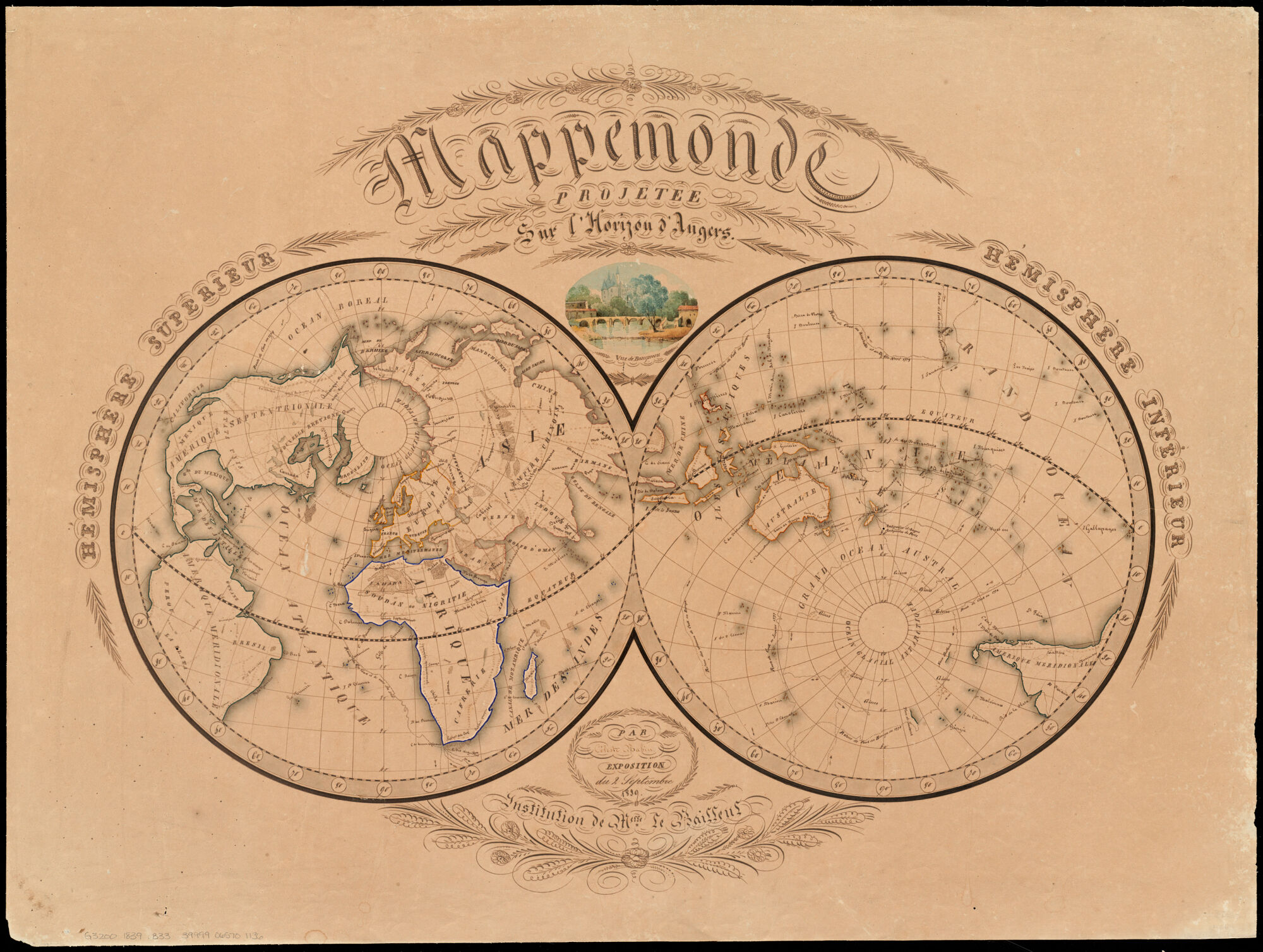
Céleste Babin, Mappemonde projetée sur l’horizon d’Angers (1839)
This student map depicts the world in a double-hemisphere, centering the left half on Angers, France, and the right on its antipode, or opposite point on earth. Drawn by a French girl in 1839, this thoughtfully conceived map includes two colored views and extensive calligraphy in a fine hand. The unusual elliptical design places the northern and southern borders meshing with the two hemispheres for a unique overall presentation of the world, most likely based on a similar map from an early 19th-century French world atlas.
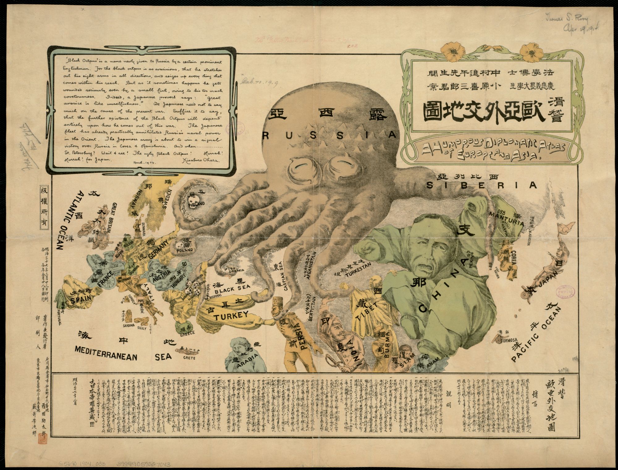
Kisaburō Ohara, A humorous diplomatic atlas of Europe and Asia (1904)
Created during the Russo-Japanese War (1904-1905) by a student at Keio University, this propaganda map presents a negative image of the Russian Empire. It is depicted as an over reaching “black octopus” extending its tentacles throughout Europe and Asia, with the other countries represented as human figures. Some countries like China thwart the attack, while others, including Persia and Tibet, are firmly in its grasp. Labeled in both Japanese and English, the map is definitely pro-Japanese. The author portrays Japan as a battle-ready soldier facing the octopus with a gun in one hand and a flag in the other.
David W. McCord, History 2 (1914)
Progressive 19th-century educators such as Emma Willard and William Channing Woodbridge emphasized the importance of teaching history and geography simultaneously. This practice, which continued into the early 20th century, is evident in the notebook of Lincoln High School student David McCord, displayed here. David’s book from his history class in 1914 contains notes with corresponding maps, such as those related to the Roman Empire. Historical maps allowed students to visualize places in the past, as David’s map of the Holy Roman Empire does.

Our articles are always free
You’ll never hit a paywall or be asked to subscribe to read our free articles. No matter who you are, our articles are free to read—in class, at home, on the train, or wherever you like. In fact, you can even reuse them under a Creative Commons CC BY-ND 2.0 license.