Retired National Park Service Archeologist Guy Prentice recently discovered the Leventhal Map & Education Center’s copy of George W. Carleton’s 1865 map of the Andersonville prison, a notorious Confederate camp where thousands of Union prisoners of war died. Dr. Prentice has spent multiple field seasons doing archeology at Andersonville National Historic Site, and coauthored numerous reports on the archeology of the Andersonville Prison site over more than three decades during his NPS career. In this guest article, he describes how the appearance of this map in our collections helped to unlock a mystery about the trial of one of the most controversial figures in Civil War history.
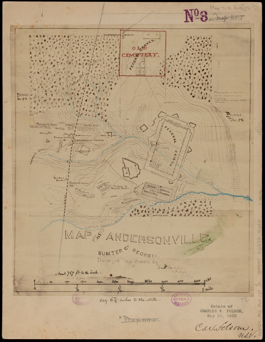
The Carleton map of Andersonville in the LMEC Digital Collections
When I discovered the digitized copy of George W. Carleton’s map in the Leventhal Map & Education Center’s collections, I quickly recognized that it was likely the same map that was exhibited and referred to during the trial of Andersonville Prison’s much reviled commandant, Captain Henry Wirz. Wirz had the ignominious distinction of being the only person tried, convicted, and executed for war crimes at the end of the Civil War, though many view him as a scapegoat that was wrongly blamed for the nearly 13,000 Union prisoners that died at Andersonville between the time when the first prisoners arrived there on February 24, 1864 and the day that Wirz was arrested on May 7, 1865.
Identifying this map as the one that was used in the trial was possible due to some of the particular features that appear on the map. These features were referred to by different witnesses at several points during the Wirz trial; the most important clue is found in the following comments made by Major General John Harrison Wilson while he was on the witness stand in 1865.
This survey was made by my directions for the purpose of giving proper information to the War Department as to the situation of affairs at Andersonville. It is simply a survey of the projection of the surface of the ground and of the buildings. […] I can say that this map is quite accurate, because I examined the whole ground myself, and I know that the whole map was made with particular care by measurement, and was directed to be made accurately. This, together with pencil sketches, which were sent about the same time, will give quite as accurate an idea as could be obtained without a personal inspection of the ground. (Trial 1868, pp. 275–276)
Some of the specific map details that General Wilson pointed out while making references to the Wirz trial map provide evidence leading to the conclusion that the Map of Andersonville, Sumter Co., Georgia in the possession of the Boston Public Library is the Wirz trial map. These include Wilson’s statement that the topographic map presented during the Wirz trial featured contour lines drawn at 5-foot intervals, and also the labeling of Sweetwater Creek as Little Sweet Water Creek; this latter description is a detail missing from any other known contemporary maps.
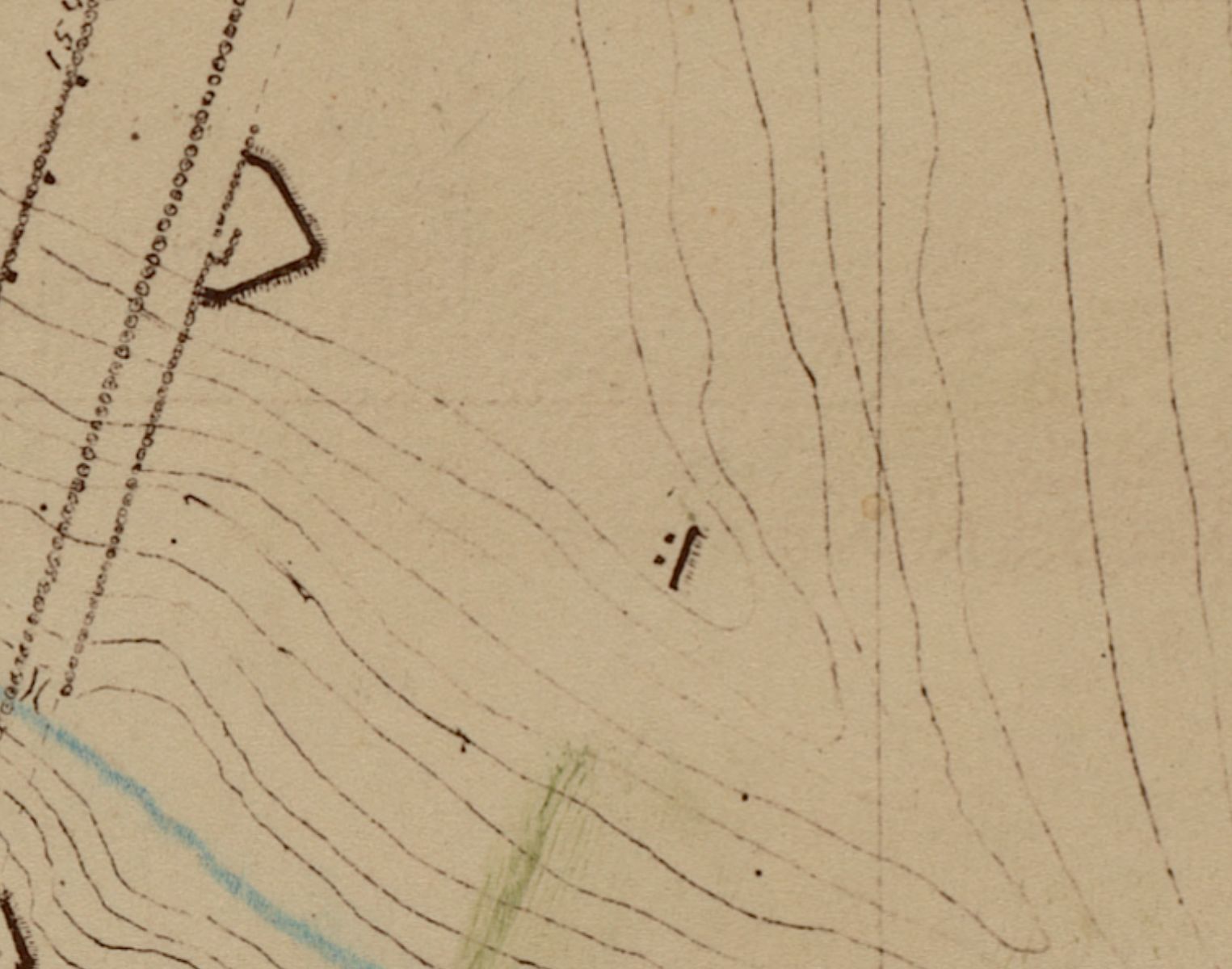
The black line and two dots at the center of this excerpt show the “piece of embankment” mentioned by Wilson
Another revealing piece of evidence is Wilson’s statement that “a piece of embankment was thrown up here to protect these guns from the hill in the rear.” No doubt Wilson was referring to the small section of embankment that appears on the map roughly 400 feet southeast of Andersonville prison’s East Side Redan. This piece of embankment still exists at the same spot at Andersonville National Historic Site where it is a small, fairly inconspicuous archeological feature that was unknown prior to its discovery by NPS park staff and subsequent investigation by NPS archaeologists in 2014.
The other evidence leading to the conclusion that the Map of Andersonville, Sumter Co., Georgia held by the Boston Public Library is the Wirz trial map is the provenance based on the identity of its creator, George W. Carleton. Carleton was an Assistant Engineer in the Provisional Confederate Army who was captured by the U.S. Second Cavalry on April 20, 1865 in Macon, Georgia (Goodspeed Publishing Company 1888, pp. 1186-1187). The U.S. Second Cavalry formed part of the U.S. Cavalry Corps of the Military Division of the Mississippi, which ended their successful raid through northern Alabama and Georgia by capturing the town of Macon on April 20, 1865 under the command of Maj. General John H. Wilson.
After being granted parole, Carleton was sent to Andersonville under orders issued by Maj. General John H. Wilson to produce a topographical survey of the prison and its surroundings. The map that Carleton drew was then submitted to Maj. General Wilson along with his field notes before Carleton was released on June 20, 1865 and sent off to his home in Pemiscot County, Missouri where he enjoyed a successful legal profession.
Carleton likely completed his topographic survey of Andersonville Prison on May 19, 1865, the day before Captain Henry E. Noyes of the U.S. Second Cavalry left Macon to take Wirz to Washington, D.C., where they arrived by May 31, 1865 (Trial, p. 19; Townsend 1899, p. 586). Five days later, on June 5, 1865, Assistant Adjutant-General Edward D. Townsend sent a communiqué from his office in Washington, D.C. to Wilson in Macon informing him that he had received a number of items that Wilson had sent to him. The received items had been delivered by Noyes, the man responsible for escorting Wirz to Washington, D.C. for trial in late May 1865 (Noyes 1868:19). Included among the delivered items were “a topographical map and some sketches of Andersonville Prison” (Townsend 1897, p. 960). Based on this sequence of events, it seems a firm conclusion that the topographic map that Townsend had received from Noyes was the one drawn by Carleton.
A monument to Massachusetts soldiers at Andersonville. Lee Library/Digital Commonwealth
What is most important about the recent historical contextualization of Carleton’s Andersonville map is that it offers previously unavailable details concerning the layout of the prison camp for both historians and archeologists. It also serves to answer a number of archeological questions that were previously unanswered in other available historical sources. It would take a long time to list all of the ways that the Carleton map has aided our understanding of the archeology at the prison camp, but, in terms of big picture information, this map crucially offers unambiguous documentation about where the camps of the 2nd, 3rd, and 4th Georgia Reserves and the Florida Light Artillery were located while they served as prison guards.
Also revealed in the Carleton map is the extent to which the construction of the three stockades had been completed. Other available historical sources were not unanimous as to whether or not the Second Stockade that connected the multiple earthworks constructed around the prison pen had been completed, but the Carleton map shows that it was essentially done. And, although most historical sources had agreed that the outermost Third Stockade was not fully constructed, it wasn’t known how far the work had progressed toward its completion. Carleton’s map shows that only short sections of the Third Stockade wall had been completed, mostly on the eastern side of the prison, even though the trenches were dug to receive the stockade posts along the prison’s northern and southern ends. Finally, the map also revealed the extent to which the Shed Hospital located south of the prison pen had been furnished with sheds and enclosed within its own stockade.
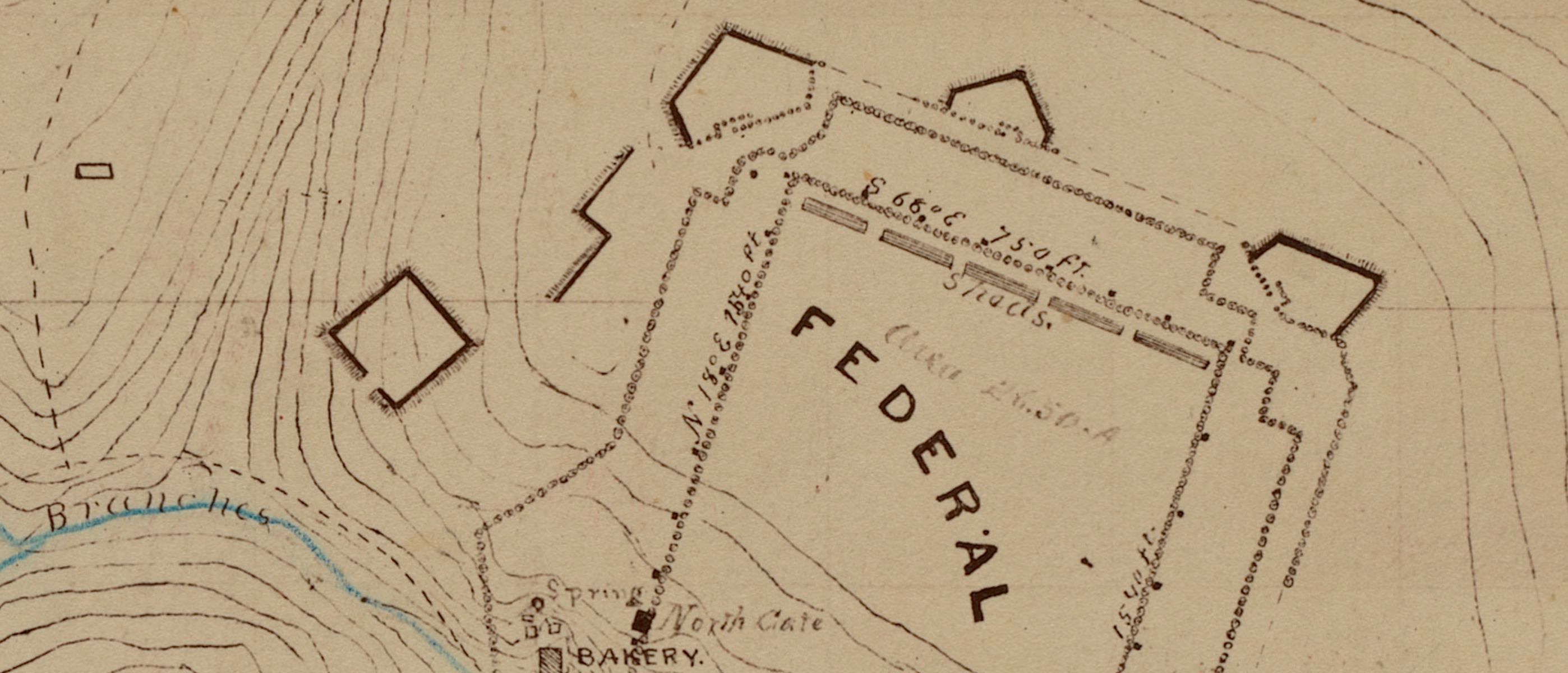
This excerpt shows the various stages of completion of the stockades surrounding the prison
For all of these reasons, the Carleton map is one of the most important pieces of documentary evidence available about what was going on at Andersonville Prison near the end of the Civil War—and its status as a key piece of legal evidence used in the infamous Wirz trial makes it all the more interesting.
References
Goodspeed Publishing Company. 1888. History of Southeast Missouri: Embracing an Historical Account of the Counties of Ste. Genevieve, St. Francois, Perry, Cape Girardeau, Bollinger, Madison, New Madrid, Pemiscot, Dunklin, Scott, Mississippi, Stoddard, Butler, Wayne and Iron, and Including a Department Devoted to the Preservation of Personal, Professional and Private Records. Goodspeed Publishing Company, Chicago.
Trial of Henry Wirz. 1868. Executive Document 23, House of Representatives, 40th Congress, 2nd Session. Government Printing Office, Washington, D.C. Online at HathiTrust.
Townsend, Edward D. 1897. Correspondence sent from War Department, Adjutant-General’s Office, Washington, June 5, 1865, addressed to Bvt. Maj. Gen. J. H. Wilson, Comdg. Cavalry Corps, Military Division of the Mississippi. In The War of the Rebellion: A Compilation of the Official Records of the Union and Confederate Armies, Series 1, Vol. 49, p. 960. U.S. Government Printing Office, Washington, D.C.
Townsend, Edward D. 1899. Correspondence sent from War Department, Adjutant-General’s Office, Washington, May 31, 1865, addressed to Major-General Augur. In The War of the Rebellion: A Compilation of the Official Records of the Union and Confederate Armies, Series 2, Vol. 8, p. 586. U.S. Government Printing Office, Washington, D.C.
Our articles are always free
You’ll never hit a paywall or be asked to subscribe to read our free articles. No matter who you are, our articles are free to read—in class, at home, on the train, or wherever you like. In fact, you can even reuse them under a Creative Commons CC BY-ND 2.0 license.