Leventhal Map & Education Center Opens "Getting Around Town: Four Centuries of Mapping Boston in Transit" on September 9
A new, free exhibition at the Boston Public Library animates the history—and future—of Boston’s public transit systems
Boston, MA - The Leventhal Map & Education Center at the Boston Public Library will launch its latest free exhibition this fall with the opening of Getting Around Town: Four Centuries of Mapping Boston in Transit on September 9, 2023.
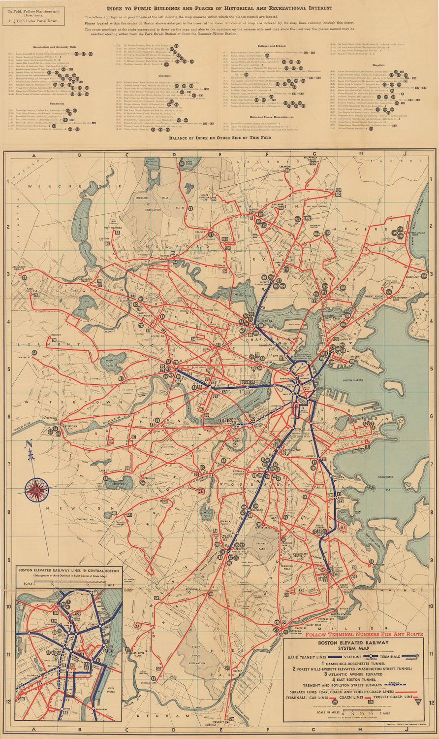
By referencing both sides of this 1936 BERy System Route map , one could locate a desired route, track operating frequencies, plot connections, and navigate all modes of the BERy’s network.
Getting Around Town, the Leventhal Center’s first-ever show focused on public transportation and mobility, brings together an extraordinary collection of maps, plans, ephemera, and other materials to investigate how Bostonians have moved around the city in the past, present, and future.
Getting Around Town is guest curated by Steven Beaucher, the author of the book Boston in Transit (MIT Press) and the owner of WardMaps LLC in Cambridge. The exhibition pairs Beaucher’s own collections with the extensive holdings of the Leventhal Center and the Boston Public Library.
In the exhibition, located at the Leventhal Center gallery at the Central Library in Copley Square, visitors will explore the story of Boston's evolving transit infrastructure and how it has shaped the city as we know it today. From the early days of horse-drawn carriages and streetcars to the modern-day subway system, the exhibition will showcase the innovative ideas and technological advances that have transformed Boston's transportation landscape over the past four centuries.
"Boston has sanctioned some form of public transportation since the city’s founding in 1630,” says Steven Beaucher. “We’ve been doing this longer than any other city in the United States. With an unparalleled collection of maps and complimentary ephemera, this exhibition looks back on how people got around town, and how the routes and modes they used evolved along with the city itself, from one simple ferry to the regional multi-modal network of today’s MBTA."
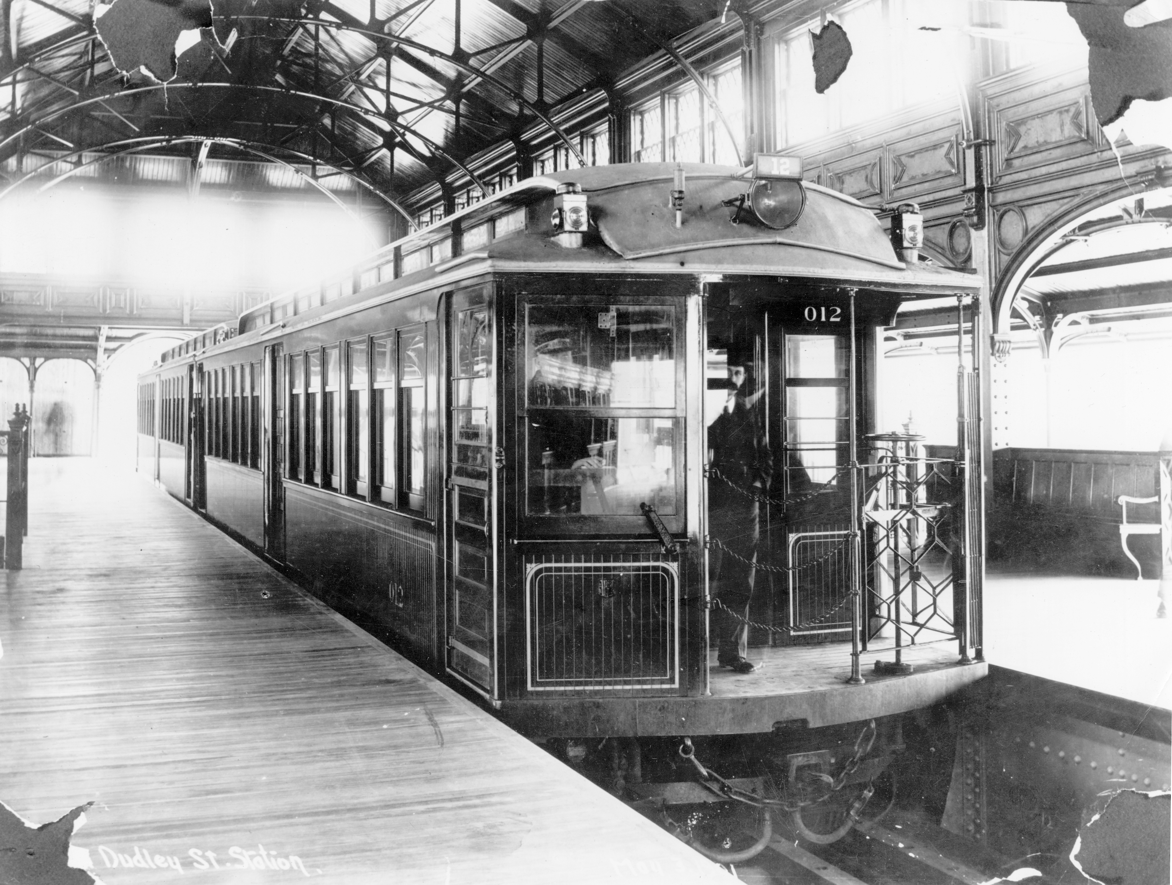
A test train of BERy Elevated Type 1 rapid transit cars pauses at the upper level of Dudley Terminal in this 1901 photograph.
One of the goals of this exhibition is to spark conversation and invite questions about the future of transportation in Boston. Visitors will be encouraged to reflect on how the city's transit system can continue to evolve to meet the needs of its residents and visitors, and how issues of transit justice weave together with other efforts to make Boston more equitable and accessible.
“Maps of transit systems are among the most widely used maps in our daily lives, and for that reason maps are almost visually synonymous with these ways of getting around the city,” says Garrett Dash Nelson, the Center’s President and Head Curator. “In this exhibition, though, we want people to think not only about what the Boston transit system is like today, but also how it was built over time, and what it might look like in the decades to come.”
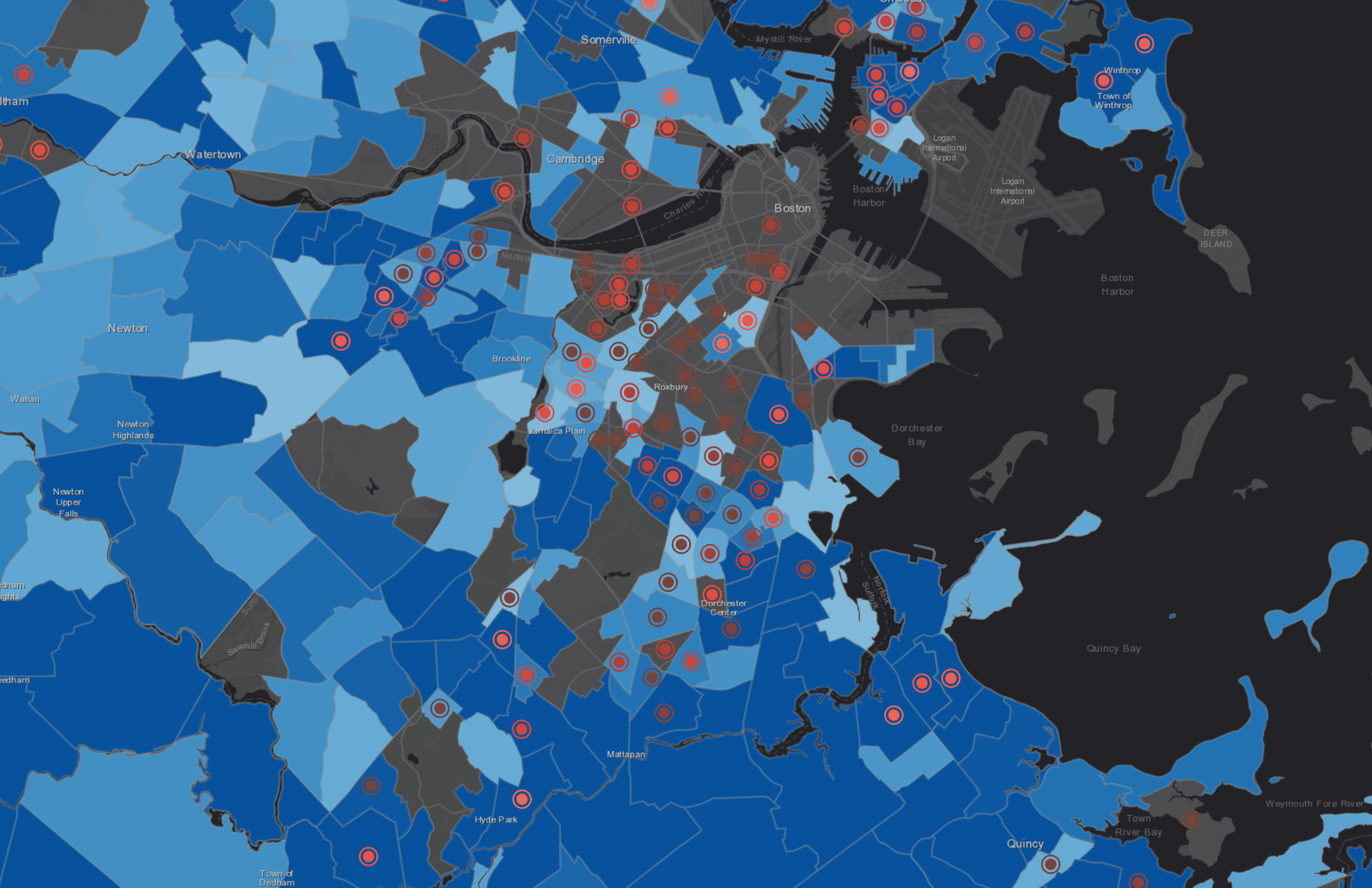
A modern map by Boston Latin School student Gideon Neave considers commute time (blue) and household income (red), and shows that people with less income are often subject to longer commute times.
Getting Around Town also features the work of high school students who worked with the Center’s K-12 Education team through a career development program funded by the Private Industry Council (PIC). The students’ digital maps explore issues around challenges and opportunities with the present-day public transit network.
PUBLIC ACCESS AND PROGRAMMING
Like all Leventhal Center exhibitions, Getting Around Town is free to all. Visitors will find information about gallery hours and events, as well as a companion online exhibition, at leventhalmap.org. Guided tours of the gallery are available for free on a regular basis, and K-12, university, and group visits are available by appointment.
Exhibition programs for adults will be available throughout the course of the exhibition, both online and in person. An updated calendar of events and programs associated with Getting Around Town can be found at leventhalmap.org/event. Getting Around Town closes on April 27, 2024.
EXHIBITION SUPPORT
The exhibition is supported by a grant from the Barr Foundation. “Greater Boston has such a rich transportation history with many firsts in the nation – including inspiring moments when community members got organized and made their voices heard for big solutions that worked for them and made this city better, more accessible, more inclusive, and more equitable,” said Lisa Jacobson, senior program officer for mobility at the Barr Foundation. “Connecting Jamaica Plain, Roxbury, and the South End with the Orange Line and Southwest Corridor Park instead of tearing them apart with the original planned route of I-95 is one example; so is the more recent Green Line Extension. The Leventhal Center’s Getting Around Town exhibition provides an opportunity to appreciate stories like these and be inspired to help champion the next innovative transportation solutions to make our future even better.”
ABOUT THE LEVENTHAL MAP & EDUCATION CENTER
The Norman B. Leventhal Map & Education Center at the Boston Public Library is an independent nonprofit organization that promotes the public use of more than a quarter million geographic objects for the enjoyment and education of all. Uniquely positioned in a public library, the Leventhal Center offers exhibitions and public talks, groundbreaking educational programs that promote geographic and data literacy, and extensive digital resources.
The Leventhal Center is known for the size and significance of its collection, as well as its engagement with K-12 audiences. With a global scope and a regional specialization in Boston and New England, the Center is a leader in exploring the study of places, societies, landscapes and history through the lens of maps and geography.
ABOUT THE BOSTON PUBLIC LIBRARY
Established in 1848, the Boston Public Library is a pioneer of public library service in America. It was the first large, free municipal library in the United States; the first public library to lend books; the first to have a branch library; and the first to have a children’s room.
The Boston Public Library of today is a robust system that includes the Central Library in Copley Square, 25 neighborhood branches, the Norman B. Leventhal Map and Education Center, the Kirstein Business and Innovation Center, and an archival center, offering public access to world-class special collections of rare books, manuscripts, photographs, and prints, along with rich digital content and online services.
The Boston Public Library serves nearly 4 million visitors per year and millions more online. All of its programs and exhibitions are free to all and open to the public. The Boston Public Library is a department of the City of Boston, under the leadership of Mayor Michelle Wu. To learn more, visit bpl.org.
CONTACT
Leventhal Map & Education Center at the Boston Public Library
Central Library in Copley Square
700 Boylston Street
Boston, MA 02116
Phone: 617-859-2387
Email: info@leventhalmap.org