Last week, to observe the end of 2020, we published maps of the 20s on our social media—that is, one map each from 1520, 1620, 1720, 1820, 1920, and 2020. Take a look back at our century-by-century wrap up of the 20s!
1520 - The Heartland
![Peter Apian, Tipus orbis uniuersalis iuxta Ptolomei cosmographi traditionem et Americi Vespucii alior[um]que (1520)](https://iiif.digitalcommonwealth.org/iiif/2/commonwealth:3f463b65n/full/,1200/0/default.jpg)
Peter Apian, Tipus orbis uniuersalis iuxta Ptolomei cosmographi traditionem et Americi Vespucii alior[um]que (1520)
Petrus Apianus made this map. He was highly regarded in his day as a mathematician, cartographer, and author of a book on astronomy. This was the second known map to adopt the German cartographer Martin Waldseemüller’s term “America.” The continent’s new name is inscribed on the landmass, along with a credit to Columbus for “finding” an island in the year 1497.
1620 - Portolan(d)
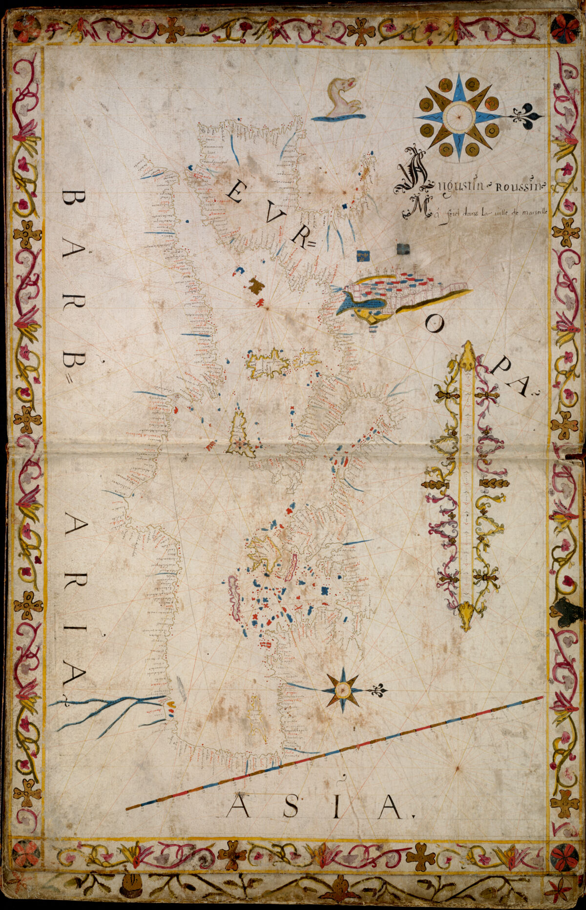
Augustin Roussin, from Portolan atlas (1620)
Next up in our 2020 countdown of maps through the centuries is this 1620 portolan! The term is from the Italian portulano and it’s easy to see, as you look at the multitude of place names along the coasts, that these charts are all about navigating to ports or harbors. The mapmaker has featured his name, Augustin Roussin, with a large fancy initial “A.”
He notes that he made this map in in the city of Marseilles, and if you zoom into the full map you’ll see the hillside buildings and towers of the city depicted in an inset that is on a much larger scale than the rest of the map, with a deep blue harbor prominently featured.
1720 - Legend Has It
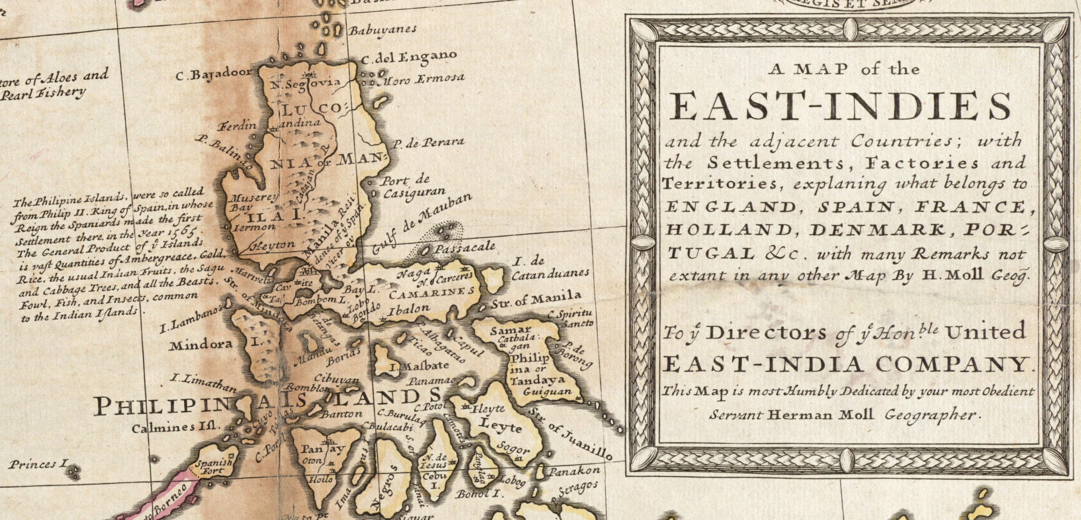
Herman Moll, John King, and John Bowles, A map of the East-Indies and the adjacent countries… (1720)
Here’s a detail from a 1720 map (or thereabouts). The title in the legend encapsulates the colonial attitude of the time: “A map of the East-Indies and the adjacent countries, with the settlements, factories and territories, explaning [sic] what belongs to England, Spain, France, Holland, Denmark, Portugal &c. with many remarks not extant in any other map… To ye Directors of ye Hon’ble United East-India Company. This Map is most Humbly Dedicated by your most Obedient Servant Herman Moll, Geographer.” The stated purpose of the map is to explain which countries own which pieces of land. Notes on various countries call out their attractive riches, like the text here by the Philippines:
“The General Product of the Islands is vast Quantities of Ambergreace [sic], Gold, Rice, the usual Indian Fruits, the Sagu and Cabbage Trees, and all the Beasts, Fowl, Fish, and Insects, common to the Indian Islands.”
This way of seeing land for its productive qualities is typical of colonialist mapping.
1820 - The Hills Are Alive
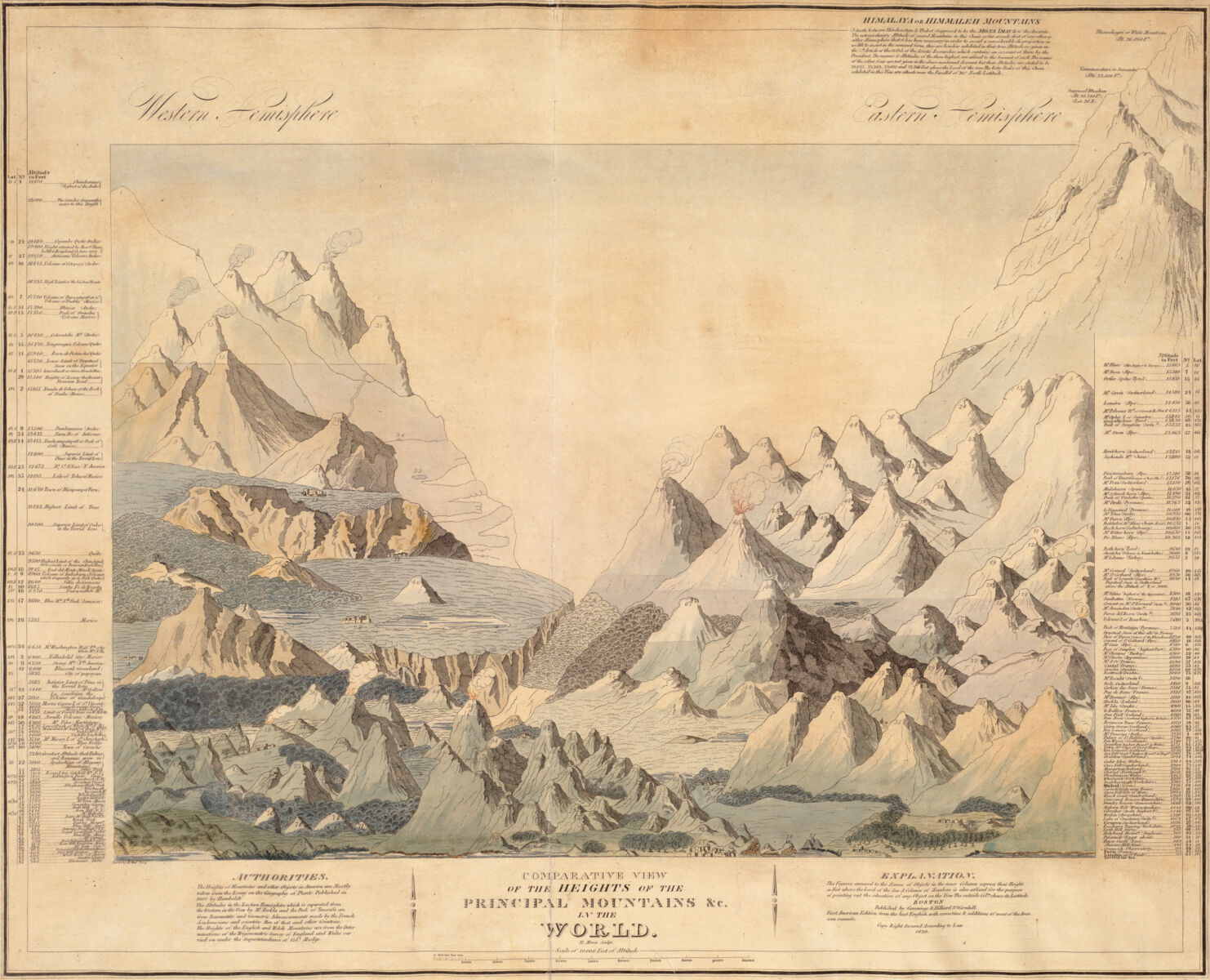
Hazen Morse, Comparative view of the heights of the principal mountains &c. in the world (Cummings and Hilliard, 1820)
This map is a view comparing the height of the world’s mountains! It was created by Hazen Morse, who was born in Haverhill, Massachusetts, and worked as a silversmith and engraver in Boston.
The chart cites Alexander Humboldt’s foundational 1807 “Essay on the Geography of Plants” as the main source for the mountain measurements. Humboldt, an explorer and scientist considered as influential as Charles Darwin, was a colorful character. An anti-slavery advocate, legend has it that when traversing the Quindiu Pass in Colombia, Humboldt refused to ride on a sillero, a man saddled with a chair. Instead, he walked.
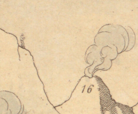
If you zoom tightly into the upper left corner of the chart, you can spy a tiny figure hiking the slope of the Andes’ Chimborazo, the highest peak in the Western hemisphere, gazing out at the collection of mountains.
1920 - Spheres of Influence
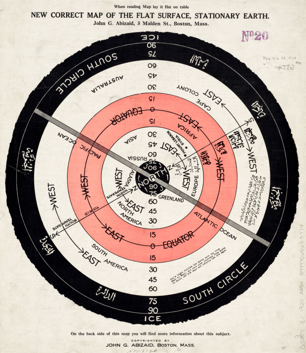
John George Abizaid, New correct map of the flat surface, stationary earth (ca. 1920)
Flat Earth theory is the disproven idea that the Earth is a flat disc. The earliest mention of the Earth as a sphere was in 5th century BC in Greece, and by 3rd century BC it was commonly known fact.
The circumference of the spherical Earth was first calculated by Greek polymath Eratosthenes in 3rd century BC, based on the distance between 2 cities and the angle of sunlight. His exact method has been lost, but a simplified method was popularized by Greek astronomer Cleomedes around 4th century BC. Cleomedes calculated the circumference as 39,375 km, 701 km less than the actual circumference of 40,076 km.

Abizaid and his map in the Boston Globe
While the Earth has been known to be a sphere since 3rd century BC, and there are multiple observations that prove the Earth is round, flat-Earthers believe and promote the idea that the Earth is flat.
This map, published in 1920 by John Abizaid, illustrates his idea of a flat, stationary Earth. Abizaid claimed that if the Earth was moving, people would feel it, and if the Earth were round, people would fall off.
In Abizaid’s model, the Earth is divided into 5 zones, with the North Pole at the center. The 5th zone, which he called the South Circle, is dark and icy. This zone prevents people from crossing and falling off of the edge of the Earth. The sun, moon and stars all move above the Earth.
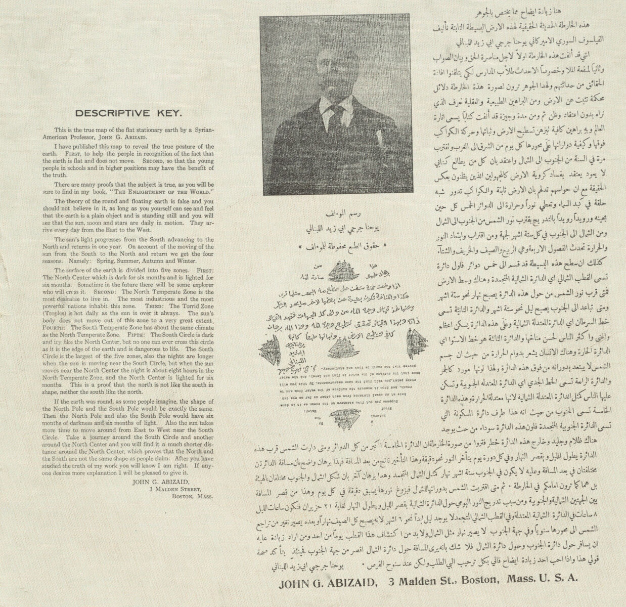
Reverse of Abizaid’s map
The map and explanation on the back are in English and Arabic. Abizaid was born in Lebanon and immigrated to the U.S. in 1889. He published a book about flat Earth theory in Arabic, which he then translated to English in 1912.
Modern flat Earthism was first promoted by English inventor and writer Samuel Rowbotham in 1849. His idea of the Earth as a flat disc centered on the North Pole, bounded on the edge by a wall of ice, is the most common flat Earth model. He founded the Zetetic Society, which after his death was succeeded by the Universal Zetetic Society. Abizaid was a president of the Universal Zetetic Society, which is now the Flat Earth Society.
2020 - Contemporary Choropleths

Check out Daniel Huffman’s maps in our Digital Collections
For our last post of the year, we offered up a little self-reflection. This set of four maps was created in 2020 for our Maptivists initiative where we teach Boston Public Schools high school students how maps can empower them to tell stories. Cartographer Daniel Huffman created these maps of Boston using American Community Survey data. The top two maps, showing change in white population and median housing value, in Boston help students visualize gentrification. The two showing free wi-fi hotspots and connectivity (or lack thereof) were created to challenge students to see how one data set can be visualized in two different ways. This can help us be better critical thinkers whenever we look at maps. Best wishes to you and yours in 2021, and happy mapping!
Our articles are always free
You’ll never hit a paywall or be asked to subscribe to read our free articles. No matter who you are, our articles are free to read—in class, at home, on the train, or wherever you like. In fact, you can even reuse them under a Creative Commons CC BY-ND 2.0 license.