This week in history is the anniversary of the invention of a classic game we all know and love: Monopoly! This game has interesting origins, and also many ties to the work we do at the Leventhal Center with maps, data, and the pursuit of equity and justice.

A colorful square board game labeled “The Landlord’s Game consists of green, blue, pink, and yellow labeled squares wrapping around the edges of the board. Lizzie J. Magie, “The Landlord’s Game board.” Created in 1906. Image courtesy of Thomas Forsyth, Wikimedia Commons.
Monopoly was invented in 1904 by Washington D.C. resident Elizabeth Magie, and was originally known as the “Landlord’s Game.” For years, credit was wrongly given to a man named Charles Darrow, who sold the game to the Parker Brothers and made a fortune. Magie, a progressive, unmarried woman, was not given due credit until decades later – but it feels extra special to now honor her invention during Women’s History Month.
Magie’s progressive political views led her to design the game as a teaching tool – an anti-capitalism statement that was meant to highlight wealth and income inequalities in America. Board games were gaining popularity in the average American household in the 20th century, so Magie thought it was the perfect way to reach and educate the general public. Once published, the Landlord’s Game grew in popularity in the early 1900s, spreading through leftist groups and college students and eventually making its way to a community of Quakers in Atlantic City, who customized the game to fit their locale. This is the classic version of the game you are familiar with today, as it was the version Charles Darrow sold and mass-produced.
A sepia-toned square of a map shows the beach, pier, and labeled Boardwalk. The boardwalk intersects long perpendicular labeled streets, and buildings and houses cover the open space. Hughes & Bailey, “Aero view of Atlantic City, New Jersey.” (New York, 1909.) Library of Congress, Geography and Map Division.
If you take a look at a 20th century map of Atlantic City, you’ll find all the same names you find on the board – Ventnor Avenue, Oriental Avenue, New York Avenue, and of course the infamous Boardwalk. Just take a look at the second image in this post, a birds-eye view map of 1909 Atlantic City from the Library of Congress.
Historical researchers, however, are shedding light on how these monopoly squares and their property values reflect the racism, economic inequality, and exclusion in 20th century Atlantic City – and, more broadly, residential discrimination in cities across America, throughout the 1900s and continuing today.
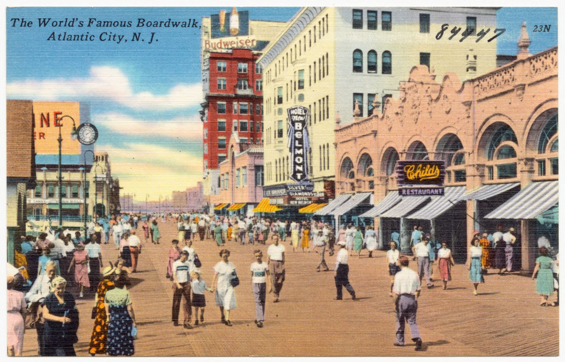
A colorful painted postcard shows a beachside boardwalk with white families walking along it, and signs point out a movie theater, stores, and a beer advertisement. “The World’s Famous Boardwalk, Atlantic City, N.J.” (1930) Boston Public Library, Digital Commonwealth.
In 1930s Atlantic City, taking a stroll on the Boardwalk (the highest priced property on the game board) was off limits to Black residents of the city. The beaches and neighborhoods in the city were segregated by race. Black residents lived in the low-income, neglected neighborhoods around Mediterranean and Baltic Avenue – the lowest value property squares on your Monopoly board. White homeowners lived in the wealthier and private neighborhoods of Ventnor Avenue and Marvin Gardens, reflected in the yellow and green middle-to-high-valued Monopoly squares.
People have, of course, invented dozens of versions of Monopoly over the last century – some to reflect their own communities or cities, and some more silly and abstract like National Parks Monopoly, Ancient Egypt Monopoly, or TV Show Monopoly. But most of the city-focused versions do still reflect the bitter and racist history of property value in real estate.
A colorful square atlas plate shows a neighborhood of Beacon Hill, including a green park labeled Louisburg Square, two tan parallel streets labeled Mt. Vernon and Pickney St., and many pink and yellow property squares, with owners’ names. G.W. Bromley and Co. “Atlas of the City of Boston, Mass.” (Philadelphia, 1888).
There have been several “Boston Monopoly” versions created over the years. The version we looked at puts Mass Ave. as the cheapest valued property, while Mt. Vernon Street takes the place of the luxury priced Boardwalk Square. Mt. Vernon Street is a residential street in Beacon Hill, where luxury townhouses around Louisburg Square are valued at $5 million; it was named the priciest street in Boston in 2019. Beacon Hill, whose North Slope used to be home to much of the city’s Black abolitionist community, is now almost 90% white.
Many Boston residents know the brutal history of residential segregation in our city – the Home Owners’ Loan Corporation (HOLC)’s “redlining” of neighborhoods in the 1930s, limits as to who could receive loans and buy homes, and the intentional discrimination underlying it all.
Many Bostonians also believe that much of the city is still residentially segregated today – and census data tells us that “of the country’s 51 greater metropolitan areas with large Black populations, Boston ranks 15th for segregation.” Boston data has also shown us alarming income disparities when comparing the average white household’s wealth and the average Black household’s wealth.
So what does all of this mean? Well, although the average player may not realize it, the Monopoly board game IS actually a useful tool for thinking about equity and wealth in America, just as Magie intended it to be. And not just in property values, but in a multitude of ways – paying a $50 fee to “Get out of Jail,” for example, reflects how wealth plays a factor in our prison and justice systems.
Monopoly is, in a way, its own map. Here at the Leventhal Map & Education Center, we use maps and data every day. Just like the monopoly game, maps can help us understand neighborhoods, specific streets, property value, and population in a specific geography. But perhaps unlike a board game, maps are not static – they change over time, and as we learn to understand them, they can empower us to make changes as well, in our cities, neighborhoods, communities, and classrooms. Maps and data can tell us a lot about equity and justice– who has access and who doesn’t, who’s included and who’s excluded, and how boundaries define or don’t define communities. Both the monopoly board and maps and data remind us of the ongoing struggle for equity and justice in housing and our communities today. But while Magie’s classically tiled board may not change, we can do the work to change the neighborhoods it reflects in real life.
Our articles are always free
You’ll never hit a paywall or be asked to subscribe to read our free articles. No matter who you are, our articles are free to read—in class, at home, on the train, or wherever you like. In fact, you can even reuse them under a Creative Commons CC BY-ND 2.0 license.