On March 29, we hosted From The Vault: Bus Networks of Boston, co-sponsored by TransitMatters!
From The Vault is a biweekly event series showing collections objects selected by Leventhal Center staff. During this event, we viewed historic MBTA transit maps of some of the most trouble-inducing routes of modern times. Buses, trains, trackless trolleys routes were presented and staff from TransitMatters spoke about "bus bunching" and facilitated conversation around the ways Boston can improve bus-centric public transit.
Boston Redevelopment Authority, Blue Hill Avenue commercial strip (1966)

This map of Blue Hill Avenue (BHA) from the 60s illustrates a thriving neighborhood along this corridor as a result of transit-oriented development. Earlier forms of public transit from the horsecar to electric streetcars connected the Roxbury, Dorchester, and Mattapan (RDM) neighborhoods, making it a vibrant residential and commercial hub. However, priorities began to shift towards the car, and buses without protected right of ways were introduced to replace the streetcar. Today, BHA remains a vibrant corridor, yet current transportation configurations fail to support the needs of the neighborhood. With the recent announcement of the center-running bus lane on BHA after a rigorous community engagement process, the community will soon receive long overdue improvements to its most vital transit corridor. BHA supports the 28 bus, the highest ridership bus in the entire MBTA network. This route experiences some of the worst bus bunching in the MBTA network as well, but these bus priority measures will be crucial to alleviating bus bunching and increasing the reliability of this corridor.
Have you heard about the BHA center-running bus lane? Do you know where to find out about city-led transportation projects?
Views of the area around Dudley Station in Roxbury (1980 - 1989?)

Nubian Station is one of the most important bus hubs in Boston. However, this bus station serves some of the slowest and most bunched buses in the MBTA network. Routes such as the 1, 15, 19, 23, 41, SL4, and SL5 terminate or pass through this station yet are plagued by bus bunching and slow speeds. Particularly the SL4 and SL5 are branded as Bus Rapid Transit (BRT), but are some of the slowest buses. Nubian Station is also a historical landmark; once part of the Elevated Orange Line, parts of the original station have been preserved and incorporated into this bus station's design. However, additional circulation planning upgrades will help these buses move more smoothly in and out of the station to prevent bus bunching and increase speeds to truly modernize Nubian Station.
Do you ride the SL4 or SL5? Do you think the service is equivalent to BRT?
Medical Area Service Corporation, A land ownership map for the Longwood Medical Area as of January 1980 (1980)
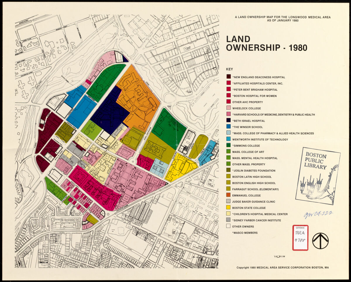
This map of the different stakeholders in the Longwood Medical Area demonstrates not only the numerous communities sharing the right of way but also the need for reliable transportation in the area. A major employment hub, Longwood and Brookline Avenue are highly utilized by shuttles, emergency vehicles, and MBTA buses alike. Serving communities all over the Boston region, reliable transportation is especially crucial in the LMA to serve the workers, students, etc. in the area.
Do you frequent the LMA area? Is it an area you find is easily transit accessible?
Frederick Law Olmsted, City of Boston plan of Columbia Road, showing connection with Franklin Park and Marine Park : under chapter 394 acts of 1897 (1897)
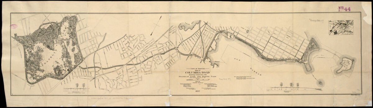
This map illustrates the City of Boston's original plan to connect Franklin and Marine Park with a greenway. Now realized as the Columbia Road Transportation Action Plan, which was introduced in GoBoston 2030, is beginning to be planned. This project aims to improve transit connectivity along the corridor through a greenway-like design and create a safer and more resilient connection for bus riders. The plan will continue this historic effort of connecting the Emerald Necklace to the waterfront, but in a way that prioritizes public transit as well.
Do you use the Emerald Necklace? Do you find that it's transit accessible?
Boston Redevelopment Authority, Massachusetts Bay Transportation Authority (1967)
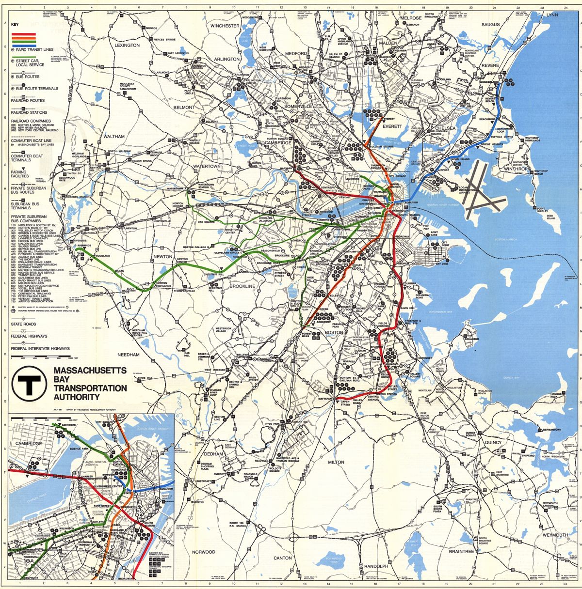
While this historic map of the MBTA network from 1967 may look vastly different from the MBTA map we know today, many of the same corridors and key locations are at the heart of each map and network. While routes have slightly changed over the years, for example, the 66 bus once terminated at Union Square in Allston rather than at Harvard or routes such as the 15 and 19 bus now serve Ruggles with the relocation of the Orange Line, key corridors and routes are still visible. Despite being critical to the transit network for decades, many of these routes lack much needed bus priority infrastructure such as bus lanes or transit signal priority (TSP), which are important to keep buses moving. This is especially important as the bus network serves a critical role in connecting communities.
Would you be able to make your commute on this historic system? Does your commute today use any bus lanes?
Massachusetts Bay Transportation Authority, Southwest corridor development plan (1979)
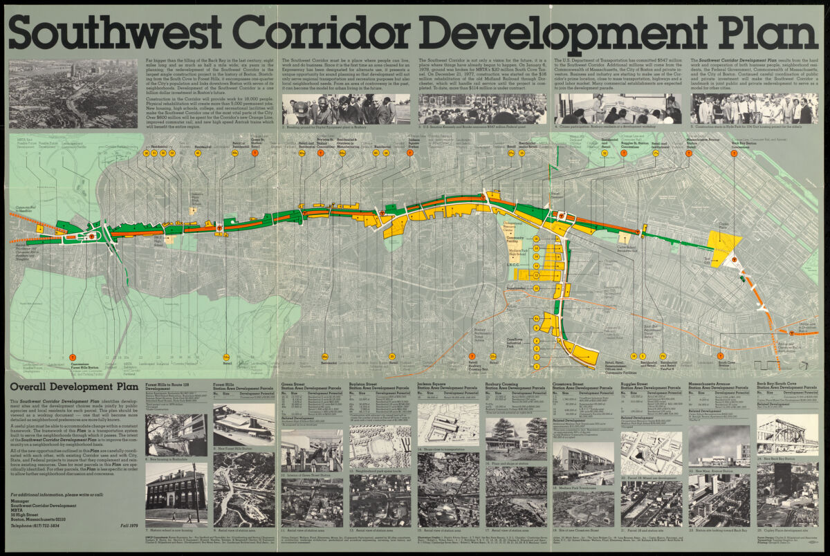
Originally planned to be transformed into a highway, the Southwest Corridor was preserved to be a multimodal corridor because of community pushback. This map shows the original plans for the construction of the Orange Line, building around existing residential and educational development. Running parallel to the southwestern Orange Line stations, many buses were rerouted to service and provide connections to the new subway stops. The Southwest Corridor is a crucial piece to Boston’s transportation infrastructure and demonstrates the significance and impact of multimodal planning that centers people.
Does your bus commute connect with the Southwest Corridor? How could your trip be improved to make your commute better?
J. Mayer & Co., Map of the city of Chelsea : from actual surveys 1867 (1867)
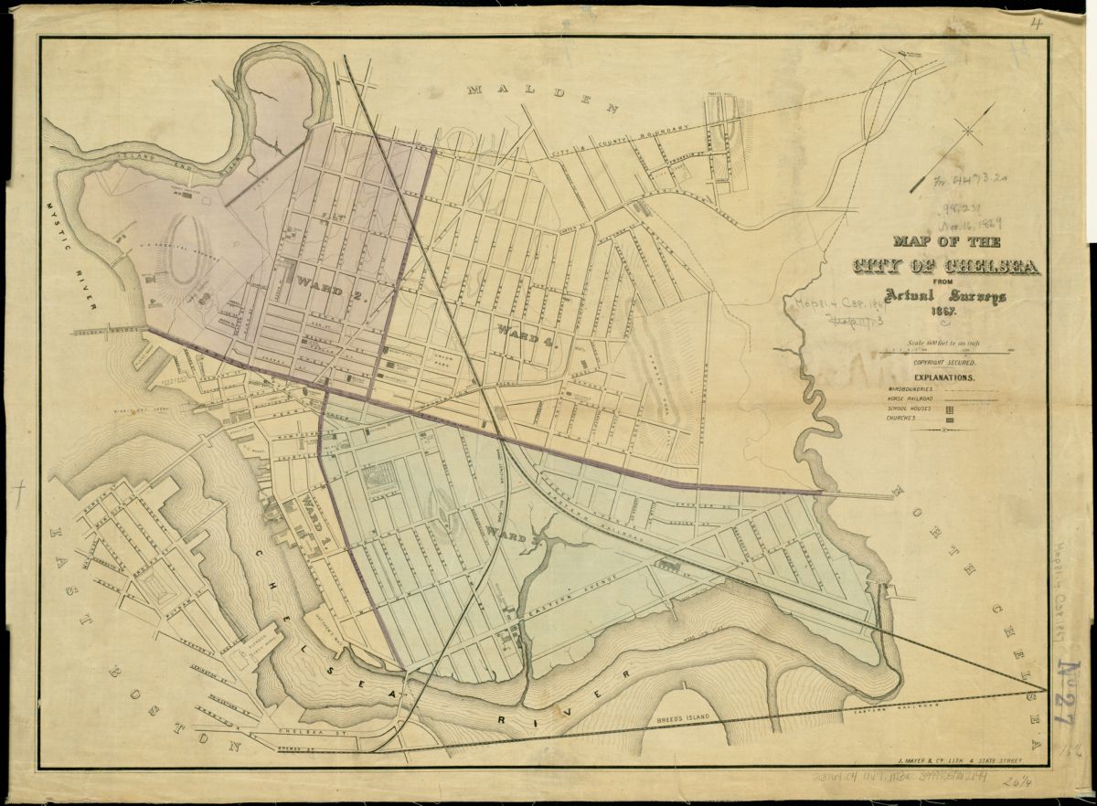
This 1867 map shows a historic view of Chelsea equipped with a streetcar route and rail lines which could have been converted to rapid transit. However, today there are limited transportation options- none of which are rapid transit. For Chelsea residents, who are largely essential employees, Latino or Hispanic, low-income, and live in an environmental justice community, there are few ways to get to Downtown Boston. Options are limited to the Commuter Rail, the SL3, the 111 bus, and the 112,114, 116, and 117 buses via the Blue Line. However, these options are often indirect, infrequent, and or unreliable.
Have you traveled to Chelsea by transit before? If you lived in Chelsea how would you commute to work or school?
Our articles are always free
You’ll never hit a paywall or be asked to subscribe to read our free articles. No matter who you are, our articles are free to read—in class, at home, on the train, or wherever you like. In fact, you can even reuse them under a Creative Commons CC BY-ND 2.0 license.