On July 25, we hosted From The Vault — Historic Currents: Charting the Evolution of Boston’s Ferry Routes, in collaboration with A Better City, Seaport Transportation Management Association and the Lower Mystic Transportation Management Association.
Did you know that the oldest ferry service in the United States was the Winnisimmet Ferry, which was founded in 1631 and transported passengers between the North End and Chelsea?
The maps chosen for Historic Currents helped patrons to learn about how transportation hubs, industries, and the destinations characterizing Greater Boston communities led the way for a variety of successful ferry routes.
Geo. H. Walker & Co, Map showing the terminal facilities of Boston (1902)

This map provides a holistic illustration of how ferries contributed to the transportation landscape at the onset of the 20th Century.
In 1902, railroads and steamboats were the predominant method of shipping freight and moving passengers. To make regional or long-distance connections more efficient, rail and boat terminals were often built in proximity to each other and were sometimes run by the same transportation companies. At this time, bridges were noticeably absent and ferries served as quick connections between hubs across the Mystic River and Boston Harbor.
The Boston and Maine Railroad & M.S.S. Co. Ferry spanned the Mystic River to connect passengers between the railroad’s Mystic Wharf terminal and the New England Gas & Coke Company plant in Everett. The Winnisimmet Ferry connected the North End and Chelsea and the East Boston Ferries connected the wharves of Downtown Boston with the Boston & Maine and Boston & Albany railroad terminals in East Boston. In addition to these local ferry services, dozens of steamboat companies operated along Boston’s waterfront, transporting passengers locally and abroad.
Today, most shipping transport is done by truck, virtually eliminating the need for many of the terminals in this map. Ferry terminals also disappeared along with the rail hubs, and for decades, there was no boat service that brought passengers across the Mystic River. Now, only the Encore Hotel water shuttle makes the connection back and forth across the river. Fortunately, the MBTA and Seaport Ferries continue to make robust service stops at docks in Downtown Boston, the Seaport, Charlestown, and East Boston.
Compiled by Whitman & Breck, Engineers, Map of the eastern junc. Broad Sound Pier, & Pt. Shirley railroad: steamboat lines and connections: established for the purpose of developing the most popular seashore resort on the Atlantic Coast [1880–1889]
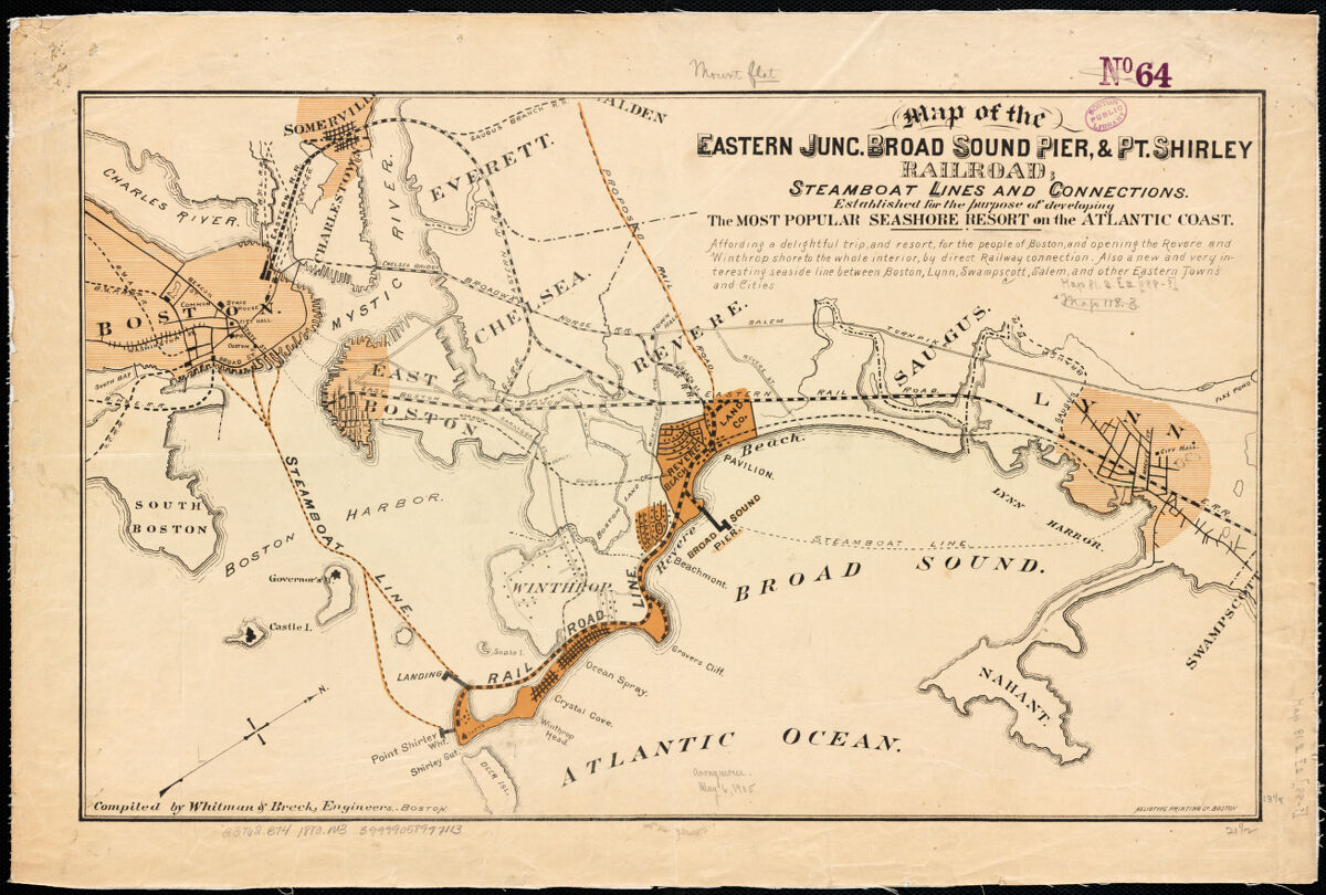
Depicted is the plan for the Eastern Junction, Broad Sound Pier, & Point Shirley Railroad at the time of its charter in 1880.
In the late 1870s, Revere Beach became a popular summer retreat for families in Boston and surrounding urban neighborhoods. Initially, the Boston, Revere Beach, & Lynn Narrow-Gauge Railroad was the main transport option for visitors. However, the Eastern Junction, Broad Sound Pier, & Point Shirley company began chartering multiple ferry routes to bring vacationers to the beach. It ran steamboat ferries from Long Wharf, Central Wharf, and Rowes Wharf to Winthrop Landing and Point Shirley, as well as an additional ferry between Lynn Harbor and Broad Sound Pier in Revere.
The branch line operated for three years “for the purpose of developing the most popular seashore resort on the Atlantic Coast.” In the fall of 1883, both railroads and their associated ferry services merged into the Boston, Winthrop, and Shore Railroad. In 1896, Revere Beach was reopened as the first public beach in the United States. Regional rail and ferry service to Revere and Winthrop’s beaches continued until 1940 and it can still be reached by public transit via the MBTA’s Blue Line. The beach’s early success as a seaside destination wouldn’t have been possible without the charter ferries and railroads whisking passengers up and down the coastline.
Geo. H. Walker & Co, Map showing the routes of The Winthrop Steamboat Co [ca. 1896]
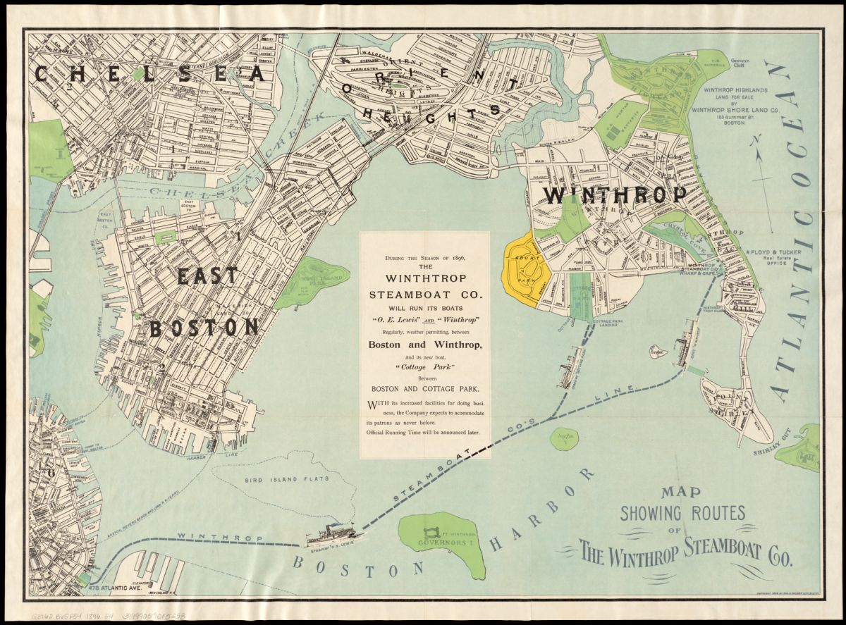
This chart reads: “During the season of 1896, The Winthrop Steamboat Co. will run its boats O. E. Lewis and Winthrop regularly, weather permitting, between Boston and Winthrop, and its new boat, Cottage Park between Boston and Cottage Park. With its increased facilities for doing business, the Company expects to accommodate its patrons as never before. Official Running Time will be announced later.”
The Winthrop Steamboat Company made a convenient connection to Downtown Boston for Winthrop residents who had work or business there, and served as a primary connection to the Boston, Winthrop, and Shore Railroad to bring city beachgoers to Winthrop and Revere’s beaches during the summer months. In this regard, the Winthrop Steamboat Company replaced ferry service that had once been provided by the Eastern Junction, Broad Sound Pier, & Point Shirley Railroad prior to its merger with the other short line railroads branching off the Eastern Railroad.
Today, the MBTA runs full 7-day service to Winthrop between 6:40am and 7:15pm, making a loop of stops at Winthrop Landing, Logan Airport, Central Wharf, and Seaport/Fan Pier. Weekend service runs from 9am until 8:10pm and combines service with the Quincy Ferry.
Bird’s eye view of Boston Harbor and south shore to Provincetown showing steamboat routes (1901)

This 1901 map was on the front cover of a pamphlet called “Bird’s Eye View of Boston Harbor and the South Shore to Provincetown Showing Steamboat Routes.”
The pamphlet was sponsored by the New York, New Haven, and Hartford Railroad, which at the time, owned and operated a passenger rail and steamboat service on the South Shore and south coast—what was then known as the “Old Colony Railroad.” The aim of the pamphlet was to encourage tourism to the areas south of Boston, and this cover provided a beautiful rendition of the South Shore. Primary steamboat lines are depicted on the map: Boston to Plymouth, Provincetown, and New York. These steamboats served to make tourism and regional vacationing more accessible to the middle class.
Geo. H. Walker & Co, Boston Harbor (1897)

Published in 1897 by the Walker Lithograph & Publishing Company, Boston Harbor provides a bird’s eye view of the harbor, including the major landmarks and steamboat routes characterizing Boston’s shoreline. Centered on this map are the economic strongholds of 1800s Boston: industrial South Boston, the historic waterfront along Atlantic Avenue in Downtown Boston, and the major East Boston shipping and rail hub connecting Boston to northern New England and the world. This map also highlights many Revolutionary and Civil War-era island forts scattered throughout the harbor, and offers a glimpse into the picturesque coastal village towns surrounding the heart of the harbor.
From this aerial view, this map illustrates the local ferry connections that carried people through the harbor during the golden age of the steamboat. In the bottom left-hand corner of the frame, the East Boston Ferries run between Lewis Mall Wharf in East Boston and “Steam Boat Landing” in the North End, which shipbuilders and dock workers might’ve used to get to and from work on the waterfront. And departing from Lewis Wharf, Central Wharf, and Rowes Wharf are the ferries that brought passengers to the region’s summertime retreats: Winthrop via the Winthrop Steamboat Company, Nahant via the “Nahant Line Steamers,” and Hull via the Nantasket Beach Steamboat Company.
Nantasket Beach Steamboat Company, Boston to Nantasket Beach and Plymouth [ca. 1915]

Through the early 20th century, Hull became famous for Nantasket Beach and Paragon Park, which attracted summer vacationers from all over Greater Boston. The Nantasket Beach Steamboat Company grew a successful business by bringing passengers from Boston and Hingham via ferry across Boston Harbor. The steamboat company also ran to Plymouth, offering easy access to a quiet retreat on the historic waterfront.
This map was originally part of a promotional pamphlet advertising the Nantasket Beach Steamboat Company’s service to these fashionable summer destinations. Paragon Park has since closed, but Nantasket Beach continues to be a popular summertime beach destination.
The MBTA runs regular commuter ferry service to Hull as part of the Hingham-Hull-Logan Airport-Boston route, which expands the utility of the ferry beyond vacationing. Today, there is no ferry service connecting Boston to Plymouth.
Boston & Gloucester Steamship Co., Boston & Gloucester Steamboat Co.: summer season 1889 (1889)

Seaside retreats and ferries that toured the coastlines have been popular summer vacation activities since the advent of the steamboat. In the late 1800s, Gloucester was a popular long-distance ferry destination for Bostonians. This brochure was distributed in the summer of 1889 by the Boston & Gloucester Steamboat Company to promote its recreational ferry service to Gloucester. These trips were just as much about sight-seeing from the ferry as they were about reaching the vacation destination.
Today, taking a ferry to one of Greater Boston’s many quaint coastal towns is still one of the summer’s best activities to do on the water. The MBTA runs ferries to Hull, which is most well known for the beautiful Nantasket Beach. Boston Harbor City Cruises also runs private, long-distance ferries to Provincetown via the Cape Cod Fast Ferry out of Downtown Boston and Salem. Alternatively, you can also get to the Cape from Boston’s Seaport via Bay State Cruise Company’s Provincetown Fast Ferry.
Our articles are always free
You’ll never hit a paywall or be asked to subscribe to read our free articles. No matter who you are, our articles are free to read—in class, at home, on the train, or wherever you like. In fact, you can even reuse them under a Creative Commons CC BY-ND 2.0 license.