On January 13, 1888, a group of 33 men came together in Washington D.C. and decided to found a society with a mission “to increase and diffuse geographic knowledge.” The Society consisted of explorers, scholars, scientists, and cartographers, as well as lawyers and businessmen, who all shared an interest in geographic learning and lived at a time of incredible global exploration, discovery, and technological change. On January 27, a certificate of incorporation was signed, bringing the small elite society into existence and kicking off an era of geographic research. Today, National Geographic is one of the largest educational organizations in the world. It is known not only for its geographic writings, but for its stunning photojournalism, environmental and archaeological conservation efforts, scientific research expeditions, and multimedia productions.
This image of a 1914 National Geographic magazine issue advertises an 18 x 22 inch fold out “Map of Europe with new Balkan Boundaries.” At the bottom, it notes that the magazine used to cost .25 cents per issue, or $2.50 for a yearly subscription.
Maps, of course, have always been an indispensable part of National Geographic's work. In 1915, the Society founded a separate Map Department to focus solely on the production of cartographic materials (today, this division is called “National Geographic Maps”). Gilbert H. Grosvenor, the founding editor of National Geographic magazine, once said, “A map is the greatest of all epic poems. Its lines and colors show the realization of great dreams.”
Before including photographs, early publications of the Society included maps. The very first issue of the magazine in 1888 included a meteorological map depicting the severe “Great White Hurricane” blizzard. (You can see an image of this map, as well as read about other early National Geographic map, in this article). Today, National Geographic continues to push the boundaries of geography and mapmaking both on and beyond the surface of our globe, including defining new oceans and remapping the solar system.
Let’s explore four early 20th-century National Geographic maps in our digital collection, each of which display unique geographic features and lend significance to their historical time periods.
Birds Eye-View of the Panama Canal (1912)
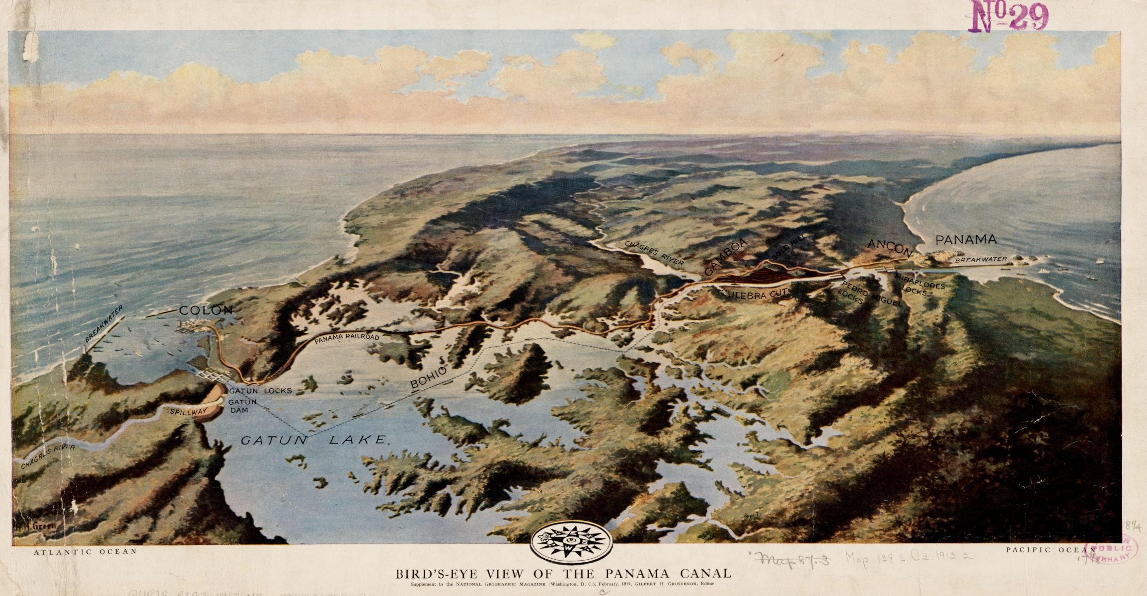
This beautiful aerial view of the Panama Canal was a “supplement” to the National Geographic magazine issue of February 1912. The Panama Canal created a passageway between the Atlantic and Pacific oceans, revolutionizing early 20th-century shipping and trade. Published two years before the Panama Canal was officially completed and opened, this map illustrated relevant canal engineering details, including locks, breakwater, and a spillway, as well as the Panama railroad running across in yellow. The funky black and white compass at the bottom adds to the uniqueness of this map.
Map of the races of Europe and adjoining portions of Asia and Africa (1919)
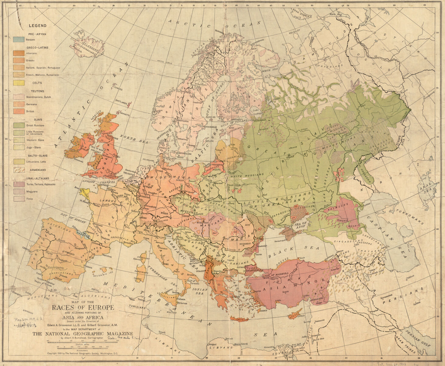
This map attempts to show the distribution of various "races" in Europe just after the end of World War I. At a time of shifting populations and changing boundaries, the mapmakers attempt to classify groups based on ethnicity and language. This is done at several levels: the colors of the legend indicate broader “racial” categories, such as “Greco-Latins,” which consists of smaller groups (Albanians, Greeks, Italians, French).
The writing on the map itself shows even more detailed classifications: for example, people in northern and southern France are divided into “langue d’oui” and “langue d’oc,” respectively – with “d’oc” being “oui” or “yes” in the spoken language of Occitan, a form of medieval French spoken south of the Loire river.
Map of China and its Territories (1912)
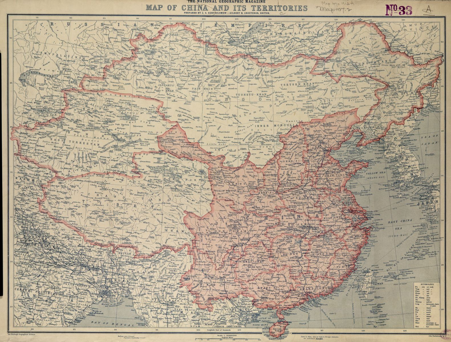
This 1912 National Geographic Magazine Map of China was published at a significant turning point in Chinese history. On February 4, 1912, the last emperor of China abdicated the throne after thousands of years of imperial rule and China became a constitutional republic. National Geographic Magazine devoted its entire October 1912 issue to China, highlighting its geography as well as its artistic, cultural, and architectural feats, and offering Westerners insight into a world and territory previously somewhat unknown to them. This map was included with that issue as a special supplement and pulls from the cartography of Edinburgh-based cartographer J.G. Bartholomew and his Edinburgh Geographical Institute. It is packed full of information, including the names of regions and cities, the locations of major railways and sea ports, and even a Chinese etymology guide on the bottom right.
White Mountains Relief Map (1937)
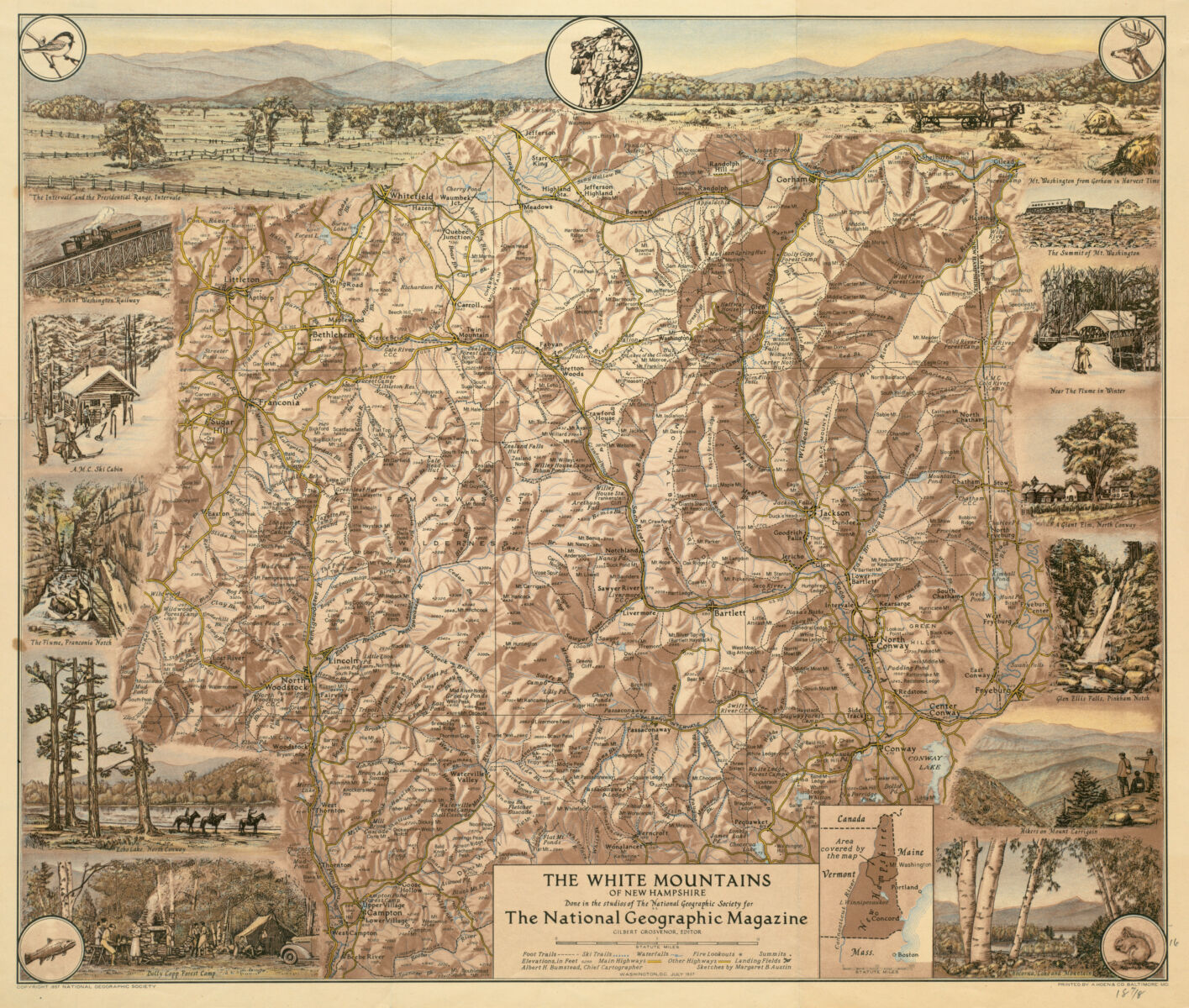
This map appeared in the July 1937 issue of National Geographic Magazine. Acting as a tourist map, it highlights scenic landmarks and shows vignettes of outdoor activities to be enjoyed in all seasons, marking foot trails, ski trails, highways, waterfalls, summits, and even landing fields for airplanes. It also does an excellent job of depicting the topography, or physical relief, of the mountainous area using shading techniques and labeling each and every mountain elevation.
Our articles are always free
You’ll never hit a paywall or be asked to subscribe to read our free articles. No matter who you are, our articles are free to read—in class, at home, on the train, or wherever you like. In fact, you can even reuse them under a Creative Commons CC BY-ND 2.0 license.