Leventhal Center staff are frequent contributors to journals and conferences in the field of cartography, geography, K-12 education, libraries and more. Former Geospatial and Cartographic Librarian Belle Lipton (now GIS Outreach Librarian at Harvard Library) and Director of Education Michelle LeBlanc were recently published in the Journal of Map & Geography Libraries. Their article, Beyond the Map: Engaging Audiences with GIS at the Leventhal Map & Education Center highlights the Center’s creation of a grant-supported public data portal to expand support to audiences using geospatial data including the Maptivists initiative working with Boston high schools.
Included here are a few excerpts from the article. If you are interested in reading it in its entirety, you can get access here.
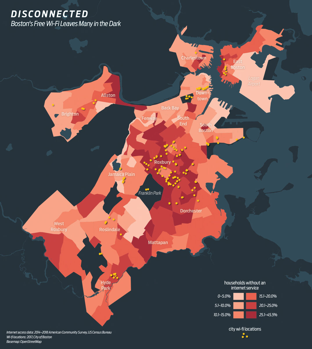
The Leventhal Center’s Maptivist initiative uses Boston-focused data maps like these to challenge students to think critically about how data can be interpreted. These two maps show contrasting views of Wifi access and absence in Boston.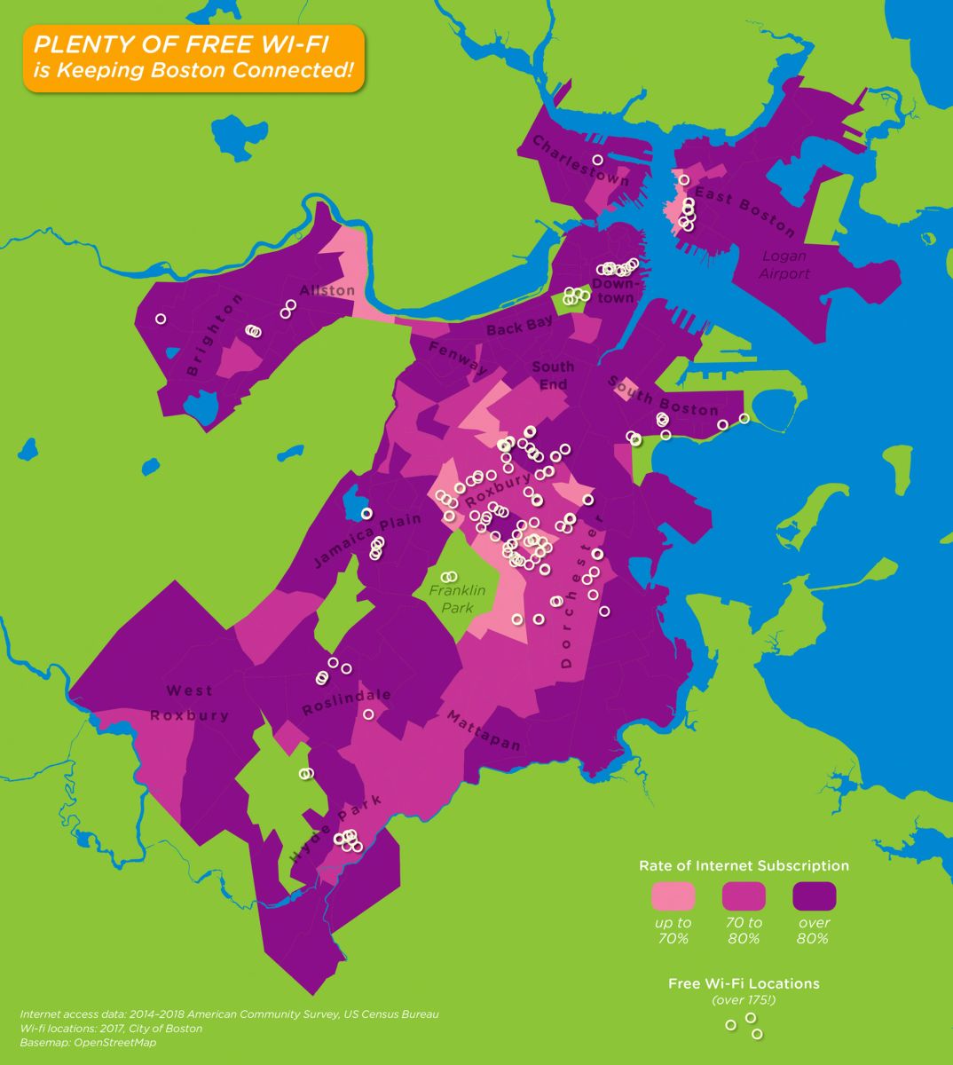
On the Data Hub Project and public course:
During this grant project, the LMEC is devising a three-part course free to all public library patrons with reserved seats for K-12 teachers, with the aim of setting up participants to start thinking spatially. We define a spatially literate person broadly as someone with the ability to operate thoughtfully within each phase of the data information lifecycle. The free course, which is explicitly not a mapmaking course, focuses on the earliest stages of the data lifecycle: data collection, acquisition, description and cleaning. The learning objectives are stated so that after taking the course, participants will be well-positioned to begin engaging in the latter phases of the spatial data lifecycle. The premise is that far too many mapmaking courses focus on the “exciting” aspects of the craft, that is, analysis and visualization. Our course takes a step back, and prepares participants to be able to more thoughtfully engage with GIS data.
On next steps for geospatial training and outreach:
From this initiative, LMEC hopes to expand training for teachers across Boston Public Schools to integrate maps and mapping into their civics instruction. The recently released Educating for American Democracy (EAD 2021) civics roadmap, highlights “Our Changing Landscape” as one of its central themes. This theme addresses the “complex experiences of harm and benefit” that occur across different places in the U.S. and how different political communities develop. Maps and data mapping are an integral element of helping students better understand this complex history. The creation and expansion of the Data Hub Project at LMEC will expand opportunities for educators to take a deeper dive into data literacy through the public courses, as well as provide an easy-to-use data resource for students who are doing research and creating maps and visualizations as part of the Maptivist initiative.
Our articles are always free
You’ll never hit a paywall or be asked to subscribe to read our free articles. No matter who you are, our articles are free to read—in class, at home, on the train, or wherever you like. In fact, you can even reuse them under a Creative Commons CC BY-ND 2.0 license.