
March 30, 2026

Henry Popple, A map of the British Empire in America with the French and Spanish settlements adjacent thereto (1775).
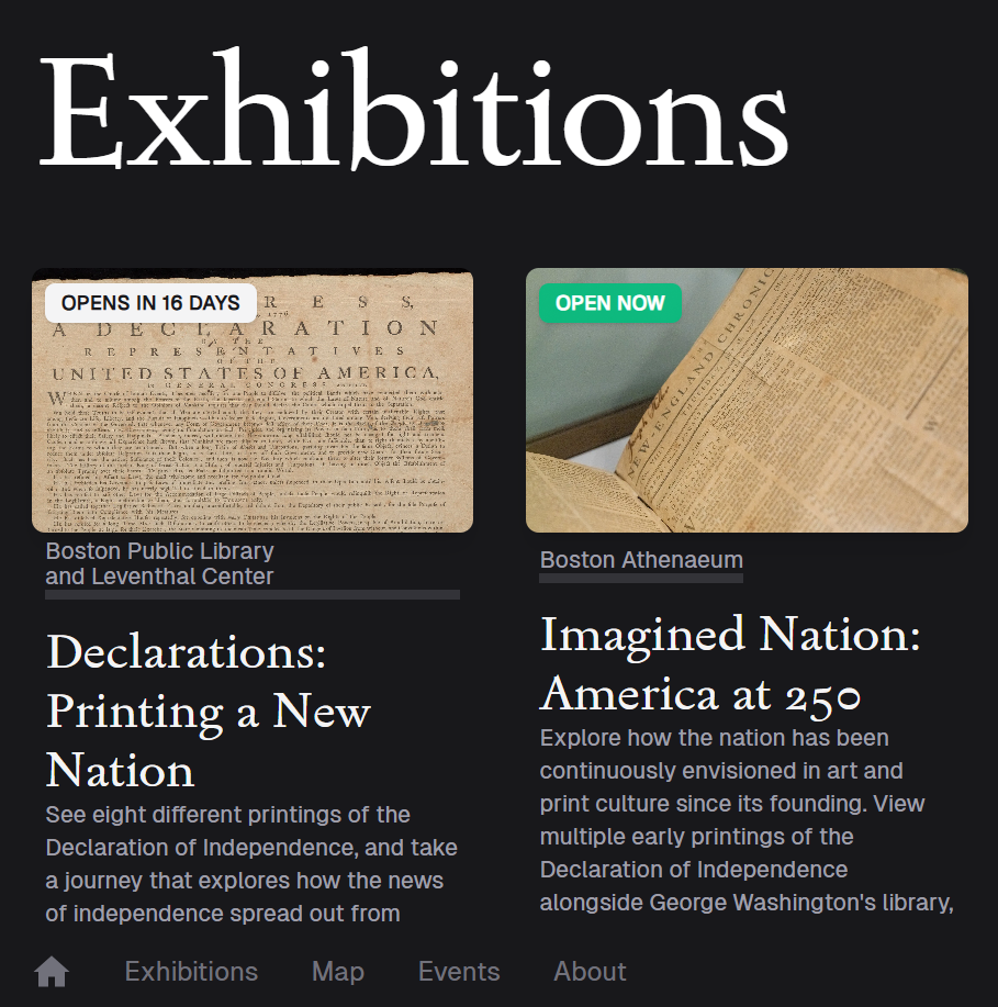
This week, we bid farewell to our exhibition Terrains of Independence—although, if you missed it, you can still explore the digital exhibition to learn more about how and why Boston became the tinderbox for the American Revolution. On April 11, we'll welcome visitors to a special new exhibition, developed in collaboration with our colleagues in the BPL's Special Collections Department: Declarations: Printing a New Nation. This exhibition brings together eight rare copies of the Declaration of Independence for the first time, and invites visitors to step into a moment when American independence, and the nation itself, were still taking shape. We hope you'll join us in the gallery this spring and summer as we take a close look at the history and geography of the first months of independence.
Follow the Declarations Trail
This spring, go beyond the Leventhal Center gallery to explore America’s founding document in a whole new way. At three additional sites in and around Boston, you can see a dozen rare copies of the Declaration of Independence—different printings, created for different audiences—brought together on public view.

An Interview With Our Spring 2026 Co-ops
We’re excited to introduce our newest staff members, Alex Ferguson and Shaolong (Carlos) Yin, both of whom are working with our team this spring in a Northeastern University co-op experience. Alex joins us as Gallery & Visitor Services Assistant, while Carlos works as Geohumanities & GIS Assistant. We sat down with them to learn more about their interests and what they've been getting up to this spring at the Leventhal Center.

Prelude to a Revolution, Part Three
This third and final installment in the “Prelude to a Revolution” series examines how maps shaped the political terrains of the early American Republic, in ways we still experience today. This digital publication was supported by the Leventhal Map & Education Center's Small Grants for Early Career Digital Publications program. Applications for this year's fellowship cycle are open through May 18.
In-Person: Bill Rankin on Radical Cartography · April 14, 1:30 pm ET
Join Yale University professor William Rankin, in discussion with Catherine D'Ignazio, for a conversation about his new book, Radical Cartography. The book—a historical, methodological, and practical exploration of data mapping—brings the last two hundred years of mapping and visualization into conversation with Rankin’s own mapping projects, which have been published and exhibited widely in the US, Europe, and Asia.
Lunch will be served and registration is required to attend.
Newsletter Trivia: Where did Bostonians first hear of independence?
Many Bostonians would have first encountered the Declaration of Independence not as a written document, but as a spoken decree. Where in Boston was the first proclamation of the Declaration read aloud?
Boston Common
Old North Church
Old State House
Old South Meeting House
As a bonus question, do you know who proclaimed the document?
The answer to last newsletter’s question about the oldest lighthouse in Massachusetts is Boston Light. Congratulations to our last winner, Tracy!
Correct answers will be included in a random drawing and the winner will receive the next three Map of the Month club postcards for free. In order to enter, make sure you follow us on Bluesky, Instagram or Facebook and direct message or email us the answer to the question. We will accept answers until April 6 at 9:00 am ET.
Just off the map
Updates from our partners, colleagues, and friends
MeL Map: This interactive map tracks the circulation of library materials since 2006 between Wayne State University and its partners elsewhere in Michigan.
Boston's New Chief of Arts and Culture, Joseph Zeal-Henry, on his Vision for Cultural Policy in City Governance: Read an interview with Boston's newest "Art Tzar" to learn more about the city's plans for interconnection between culture and urban planning.
iCivics We Declare! Challenge: In honor of nation's 250th anniversary, iCivics is offering every 8th grade student and educator in MA the opportunity to record a reading of the Declaration of Independence and receive a prize. Submission deadline is May 15.
The Leventhal Map & Education Center is an independent nonprofit. We rely on the contributions of donors like you to support our mission of preserving the past and advancing the future of maps and geography.
View this email in your browser
Leventhal Map & Education Center at the Boston Public Library
617.859.2387 · info@leventhalmap.org
{{SenderInfoLine}}