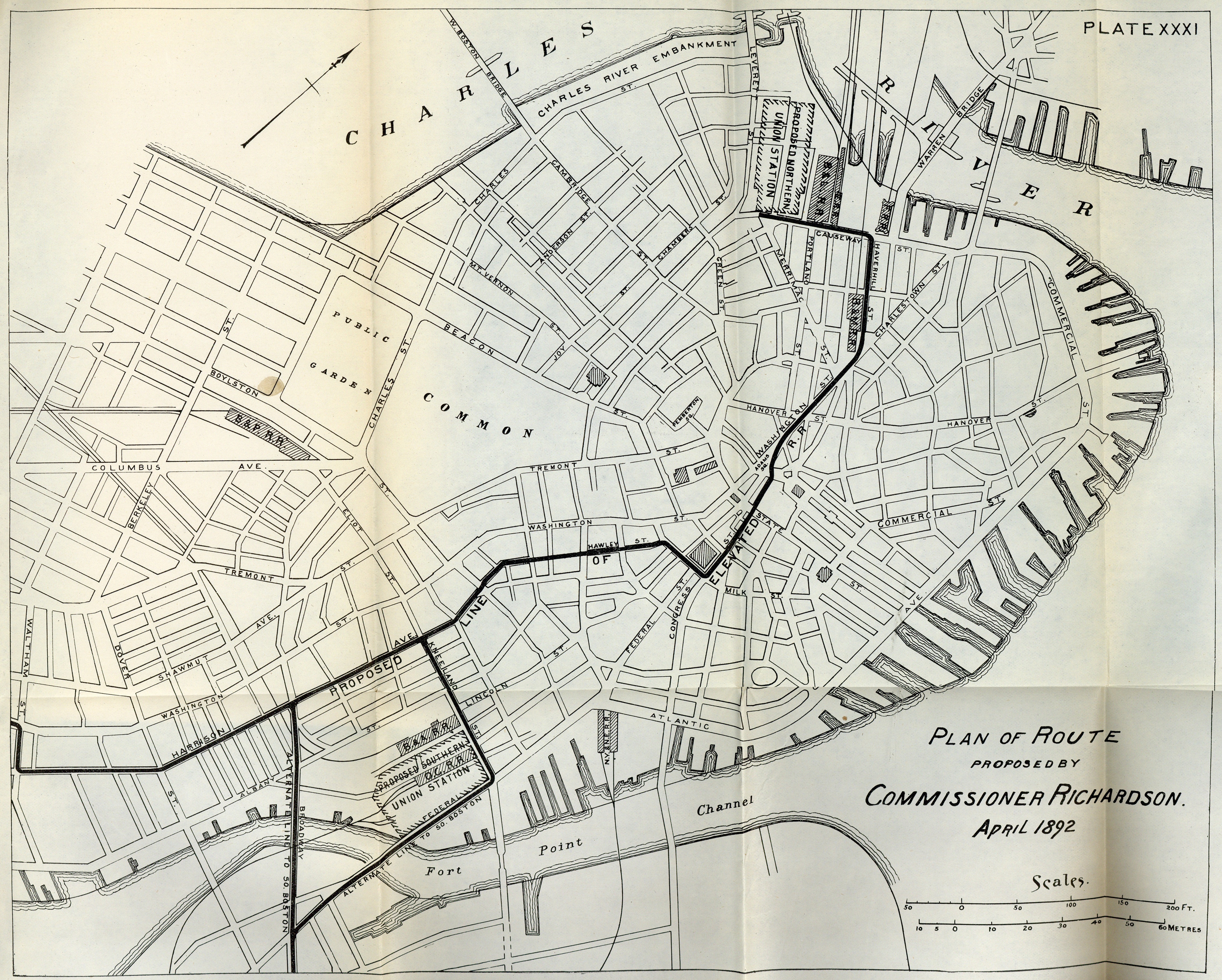
Unprecedented Improvements
Grand Terminals
By the middle of the 1850s, Boston was served by eight different steam railroad companies. The lines of these eight railroads became the foundation of the MBTA’s commuter rail network.
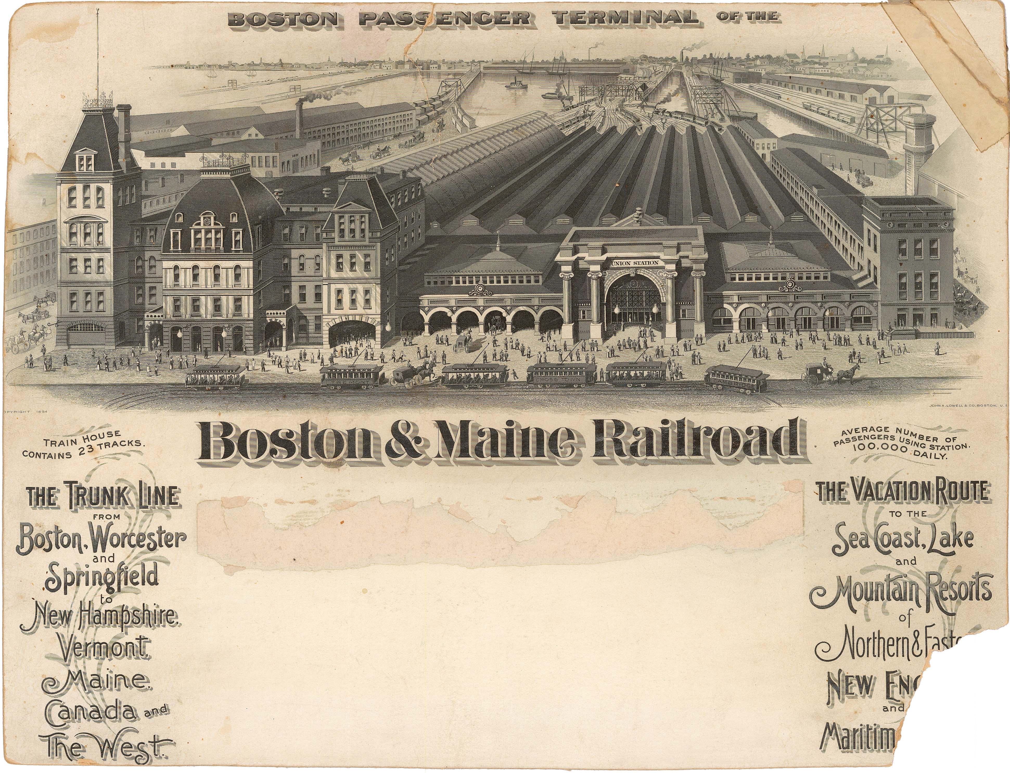
On the north side, in the late 1880s, the Boston & Maine Railroad gained control of most of the steam railroads terminating at Causeway Street. As it continued to consume other railroads and expand its tracks throughout New England, the Boston & Maine began planning a larger Boston terminal station. Union Station opened in phases during 1893 and 1894. As shown on a Boston & Maine calendar, 3.1A Union Station was composed of the existing Boston & Lowell depot with its tall tower (left) and an expansive new addition (right).
3.1A
Boston Passenger Terminal of the Boston & Maine Railroad
Boston & Maine Railroad
1894
WardMaps LLC
3.1B
North Station. Boston and Main [sic] Railroad
Fairchild Aerial Surveys, Inc.
1930
Arts Department, Boston Public Library
![Image of North Station. Boston and Main [sic] Railroad](https://iiif.digitalcommonwealth.org/iiif/2/commonwealth:6h4410699/full/,800/0/default.jpg)
To improve its Boston passenger terminal facilities yet again, from 1926 to 1928, the Boston & Maine redeveloped nearly all the land along the north side of Causeway Street. A cadastral map of the same year 3.1C shows the scope of the railroad’s new mixed-use complex, which included a hotel, the terminal station, a massive arena, and a large office building. North Station had arrived.
3.1C
“Plate 6” from “Atlas of the City of Boston: Boston Proper and Back Bay”
G.W. Bromley & Co.
1928
WardMaps LLC
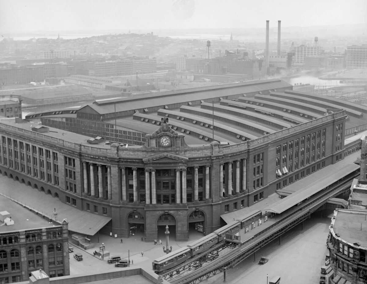
On the south side, the Boston & Albany, New Haven, and New England Railroads collaborated to establish the Boston Terminal Company. The company was established in 1896 to design, build, and operate South Station, which opened on New Year’s Eve 1898. It was a finely engineered masterpiece on par with the grand urban railroad stations of the world. Two photographs 3.1F 3.1G reveal the station’s expansive infrastructure.
3.1G
South Station From U.S.M. Building
Leslie Jones
1929
Prints Department, Boston Public Library
The site of South Station is depicted on two cadastral maps, one from 1890, 3.1D prepared before construction began, and another from 1902, 3.1E published three years after the terminal’s completion. On the 1890 map, the New York & New England Railroad’s infrastructure, along with no fewer than five parallel wharves along Federal Street, were replaced by South Station. Dominating the 1902 map and highlighted in blue, the terminal’s massive glass and steel train shed covers platforms and tracks at street level. Dashed lines trace the tunnels and run-through tracks of the station’s lower level.
3.1D
“Plate 8” from “Atlas of the City of Boston: City Proper and Roxbury”
G.W. Bromley & Co.
1890
WardMaps LLC
3.1E
“Plate 12” from “Atlas of the City of Boston: Boston Proper and Back Bay”
G.W. Bromley & Co.
1902
WardMaps LLC
The BTC & the BERy
The work of various state-appointed transit commissions of 1891–1893 culminated in the 1894 establishment of the Boston Transit Commission (BTC) and the Boston Elevated Railway Company (BERy). The BTC and the BERy brought unprecedented vision and orchestration over the planning, construction, and improvements of Boston’s public transit infrastructure for decades to come.
The BTC was a public entity, with an official seal resembling that of its namesake city. 3.2A The BTC, mostly following public mandates, oversaw the implementation of key pieces of transit infrastructure, including the Tremont Street Subway and extensions (see vertical cases behind you), the Cambridge-Dorchester rapid transit line (today’s MBTA Red Line), and rapid transit from Bowdoin Square to East Boston (today’s MBTA Blue Line).
3.2A
Official Seal from Boston Transit Commission Report
Boston Transit Commission
1897
WardMaps LLC
The Commonwealth established the BERy 3.2B as a for-profit company, initially with a mandate to construct and operate an elevated railway (also know as an “el”) through downtown Boston. After taking over the recently electrified West End Street Railway Co., the BERy established a sprawling multi-modal network integrating the latest modes of public transit.
3.2B
Official Seal from Letterhead of Boston Elevated Railway Company
Boston Elevated Railway Company
1894
WardMaps LLC
A 1916 map of the BERy’s system 3.2C reveals the scope of its operations. The BERy, after taking over the West End, oversaw one of the world’s largest public transit networks under the control of a single company.
3.2C
Tracks Operated by the Boston Railway Company
Boston Elevated Railway Company
1916
WardMaps LLC
Rapid Transit Takes Shape
Working together, the Boston Elevated Railway Co. (BERy) and the Boston Transit Commission (BTC) brought rapid transit lines to Boston. Elevated railways, tunnels, and stations erected by the BERy and BTC gave people in a burgeoning city access to crosstown travel at higher speeds and with shorter travel times.
In 1901, the BERy opened the Main Line Elevated (the genesis of the MBTA’s Orange Line), linking Sullivan Square in Charlestown with Dudley Square (now Nubian Square) in Roxbury. A May 1901 photograph 3.3C captures a BERy Type 1 elevated car at Dudley Square Terminal. The BERy regularly issued brochures to the public featuring maps 3.3A and detailed descriptions of service on its Elevated Division lines.
3.3A
Cover Page from “A Description of the Elevated Division of the Boston Elevated Railway Company”
Boston Elevated Railway Company
1905
WardMaps LLC
The BTC converted the East Boston Tunnel line from streetcar to rapid transit service and extended the line to Bowdoin Square in 1916. It also shepherded the construction of the Cambridge-Dorchester rapid transit line. The line opened in phases, connecting Harvard Square with Park Street in 1912, served by Type 1 Cambridge-Dorchester rapid transit cars. 3.3D The BTC extended the line to Andrew Square in 1918.
3.3D
Interior of BERy Rapid Transit Car #0607, 25 Nov. 1911
1911
WardMaps LLC
Throughout its tenure, the BTC issued an annual map of the status of Boston’s rapidly expanding transit network. The map from the BTC’s 1917 report 3.3E shows the Main Line Elevated as it crosses the urban core. The line splits to run through the North End as the Atlantic Avenue Elevated as well as through downtown via the Washington Street Tunnel.
3.3E
Plate 1 from “Twenty-Third Annual Report of the Boston Transit Commission”
Boston Transit Commission
1917
WardMaps LLC
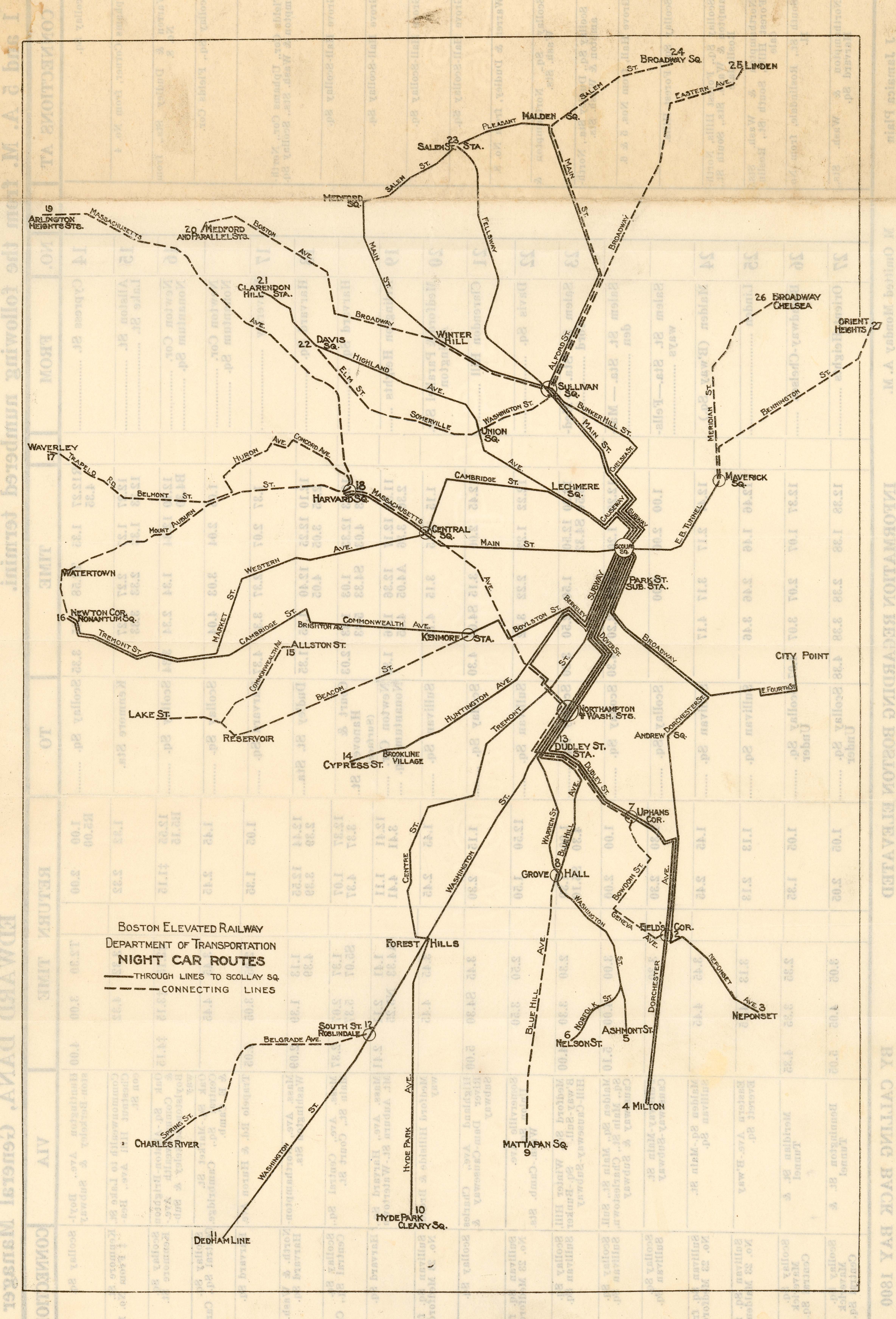
Late night service is nothing new in public transit for Boston. The BERy operated overnight transit service, as did its predecessors and successors. A 1924 brochure 3.3B maps the state of Boston’s “Night Lines.”
3.3B
“Night Car Routes” from “Night Cars: Routes and Schedules”
Boston Elevated Railway Company
1924
WardMaps LLC