Networks for a Growing City
Boston’s First Transit System Maps
By the mid-1860s, the public was conveyed on vehicles operated by a myriad of private companies, each focused on mapping their own network. Responding to a lack of paper maps that combined the plethora of transit lines crisscrossing the city, a local map maker created Boston’s first public transit “system maps.”
In 1865, a Cambridge-based civil engineer, J. G. Chase, produced a pair of maps that are perhaps the earliest comprehensive public transit maps for Boston. One map 2.1A represents Greater Boston and covers a broad area around Massachusetts Bay. The other map 2.1B zooms in on Boston, Charlestown, South Boston, East Boston, Cambridge, Somerville, and Brookline.
2.1A
Rail Road Map: Showing the Street Rail Road Routes in and Leading From Boston, With the Terminus of Each Road in Suburban Cities or Towns
J. G. Chase
1865
Leventhal Map & Education Center
2.1B
Rail Road Map of All Street and Steam Railroads in Boston and Vicinity
J. G. Chase
1865
WardMaps LLC
Both of Chase’s 1865 maps feature concentric circles drawn at quarter-mile scale increments. The center of the circles was neither City Hall nor the State House, as was common on Boston maps of similar vintage, but rather Scollay’s Building, the nodal point of all horse railroad traffic.
Portability is key to the utility of any transit map. Chase’s pocket-sized maps were excellent resources for anyone traveling via the street railways and steam railroads of Greater Boston.
An 1884 photograph of Causeway Street 2.1C captures a crushing collection of transportation vehicles within a crowded city. Confronted with this cacophony, one only needed to pull out Chase’s pocket-sized maps, unfold them, and plot a course across town.
2.1C
Building the Intercepting Sewer at Causeway Street
1884
Boston City Archives
Consolidation & Electrification
In the last two decades of the nineteenth century, the consolidation of the horse railroad companies and subsequent electrification of streetcar lines marked an enormous transformation in how people got around.
The West End Street Railway Company—typically referred to simply as “the West End”—was established in 1887 by Brookline’s Henry Whitney to service a land development scheme, brought the largest consolidation to Boston’s street railways to date. By 1891, when this map 2.2D of the West End system was published, the company had completed purchasing controlling interests in the Metropolitan, South Boston, Charles River, and Boston Consolidated Railroads, putting the majority of Boston’s streetcar system under the West End company’s control.
2.2D
Map of the City of Boston and Vicinity: Showing Tracks of the West End Street Railway
Arthur L. Plimpton
1891
WardMaps LLC
Consolidation, achieved by the West End in 1887, meant that a single fare could now pay for cross-town streetcar travel, dangerous competition for passengers between competing streetcar operators was reduced, and a vast scale of operation could justify the switch from equine to electric power. Before the switch, the two most common horsecars in operation were the closed 2.2A and open 2.2B types.
2.2A
West End Street Railway Co. Horsecar #1497 at Washington Street Car House, Brighton
ca. 1890s
WardMaps LLC
2.2B
Metropolitan Railroad Open-Type Horsecar #24 at Dorchester Avenue Car House, Boston
ca. 1860s–1880s
WardMaps LLC
West End Car #443, 2.2C originally constructed as a horsecar in 1888, was converted by the company to electric traction in 1889, becoming Boston’s first electric streetcar. By the end of 1900, the West End had replaced thousands of horses, along with their massive costs associated with maintenance, feed, and real estate for stables, with hundreds of miles of trolley wire and a bespoke network of power generating stations. The last West End horsecar serving the public trundled down Marlborough Street on December 24, 1900.
Planning for the Next Century
As Boston’s public transit networks became more and more complex, the Commonwealth and the city became increasingly involved in planning the future of transportation for the city and region, including the creation of the commissions that led to America’s first subway.
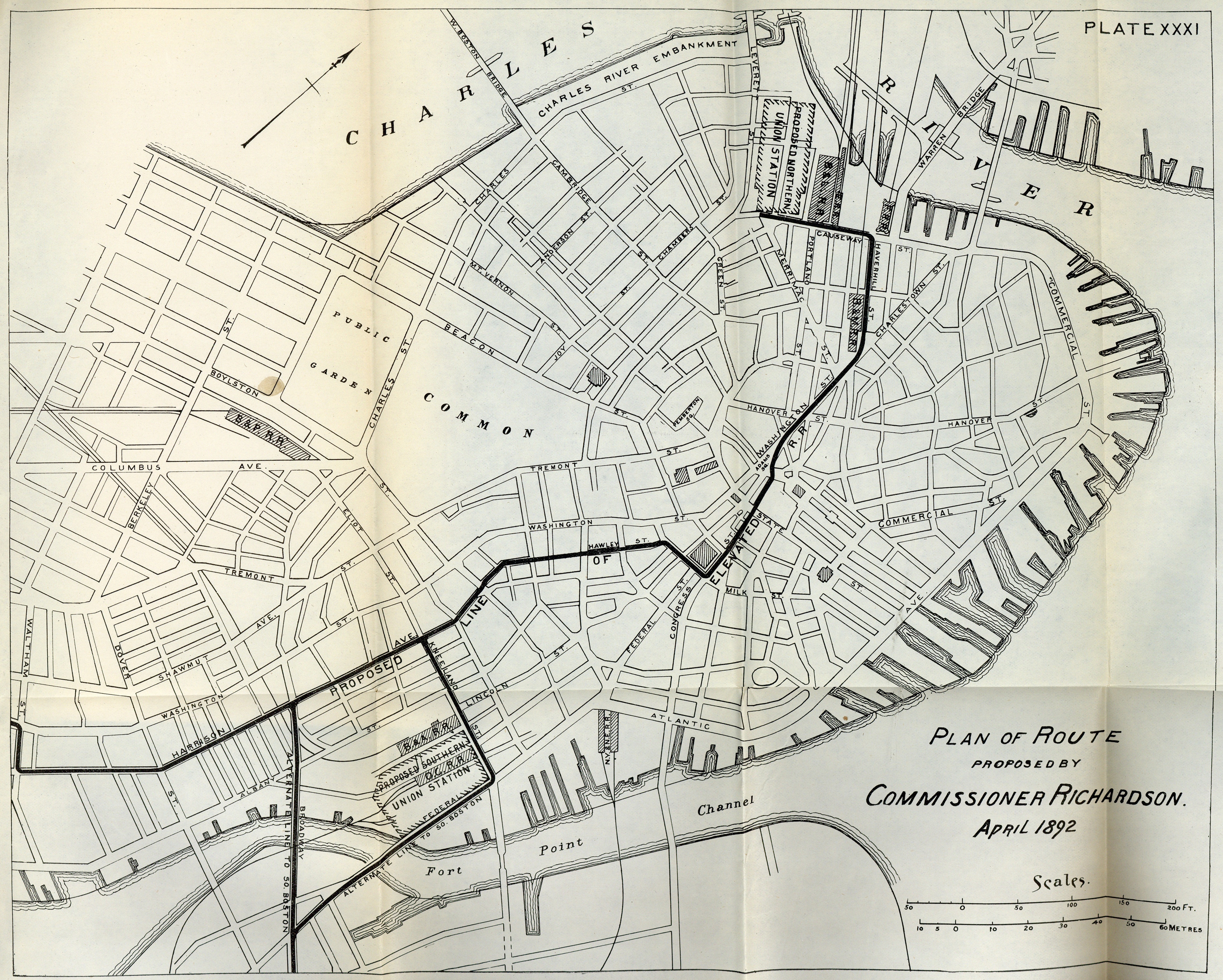
In 1891, the Massachusetts legislature formalized a “Rapid Transit Commission” charged with analyzing Boston’s existing steam railroad, street railway, and road networks, and recommending improvements for each. A significant map 2.3A from the commission’s final 1892 report anticipated a network of elevated railroad lines crossing through and radiating from downtown. This map informed subway, tunnel, and elevated railway construction for decades after it was published.
Among the Commission’s recommendations were the widening and realignment of various streets, the reworking of street railways to address streetcar congestion, the construction of a streetcar subway, the erection of elevated railways for rapid transit trains, and the consolidation of Boston’s seven steam railroad passenger terminals into two new “union” stations. The commission mapped 2.3B locations not only for both proposed union stations, but a proposed elevated steam railroad line linking the two stations together. Such a direct link existed from 1901 to 1938 as the Atlantic Avenue Elevated.
2.3A
Map Showing Elevated Railroad and Connections and Proposed Steam Railroad Changes and Connections
Rapid Transit Commission to the Massachusetts Legislature
1892
Boston City Archives
2.3B
Plan of Route Proposed by Commissioner Richardson, April 1892”
Rapid Transit Commission to the Massachusetts Legislature
1892
Boston City Archives