America’s First Subway
Understanding The Problem
The first public transit subway in America was constructed as a response to the intense street traffic which choked downtown Boston in the 1890s. VC1.1 The spine of the congested district VC1.2 ran from Scollay Square, the nexus for city streetcar lines, down Tremont Street to Boylston Street. Responding to the crisis of streetcar blockades, the state and city convened a Rapid Transit Commission whose 1892 final report mapped out solutions for Boston’s traffic problems, including potential routes to expedite street railways through downtown. VC1.4 One option, newly feasible as a result of electrification, was the conveying of streetcars beneath city streets. In preparation to carry out its mandate to build the Tremont Street Subway, the Boston Transit Commission counted streetcars and mapped the areas with the most intense streetcar traffic. VC1.3
VC1.1
“Tremont Street, Opposite Park-Street Church, During a Car Blockade, July 12, 1895” from “First Annual Report of the Boston Transit Commission”
Boston Transit Commission
1895
WardMaps LLC
VC1.2
“Plan Showing Congested District, City of Boston” from “Report of the Rapid Transit Commission to the Massachusetts Legislature”
Massachusetts Rapid Transit Commission
1892
WardMaps LLC
VC1.3
“Chart Showing Number of Cars Running on Tremont and Other Streets …” from “First Annual Report of the Boston Transit Commission”
Boston Transit Commission
1895
WardMaps LLC
VC1.4
“Plan Showing Proposed Central Routes and Suburban Connections” from “Report of the Rapid Transit Commission to the Massachusetts Legislature”
Massachusetts Rapid Transit Commission
1892
Boston City Archives
Building A Solution
The Boston Transit Commission (BTC) kicked off construction for the Tremont Street Subway in 1895. In just over three years, the subway was inserted below active city streets and portions of Boston Common. An 1898 BTC map VC2.1 shows the extent of the subway’s tunnels and stations. It was built with simple technology: men with shovels, horses carting away spoils, and rudimentary steam shovels.
VC2.1
“Boston Subway, August 15, 1898“ from “Fourth Annual Report of the Boston Transit Commission”
Boston Transit Commission
1898
WardMaps LLC
During construction, the BTC was mandated to keep street traffic, including streetcars, moving with limited interruption. Hence, the tunnels and stations of the Tremont Street Subway were generally built using three construction methods. “Cut and cover,” where a large trench was cut into the ground, the subway was constructed within the trench, and finished surfaces were installed on top, was used at Boston Common, with Park Street Station a prime example. VC2.2 VC2.3 VC2.6 The “slice method” commenced with the digging of small tunnels just big enough for a worker to move through. Builders then constructed small increments of tunnel, or “slices,” from above. The “shield method” utilized a subterranean movable steel arch that supported unexcavated earth over an area of work occurring entirely underground. VC2.7
VC2.2
“Plate 6” from “Second Annual Report of the Boston Transit Commission”
Boston Transit Commission
1896
WardMaps LLC
VC2.3
“Plate 16” from “Second Annual Report of the Boston Transit Commission”
Boston Transit Commission
1896
WardMaps LLC
VC2.7
“Plate 21” from “Third Annual Report of the Boston Transit Commission”
Boston Transit Commission
1897
WardMaps LLC
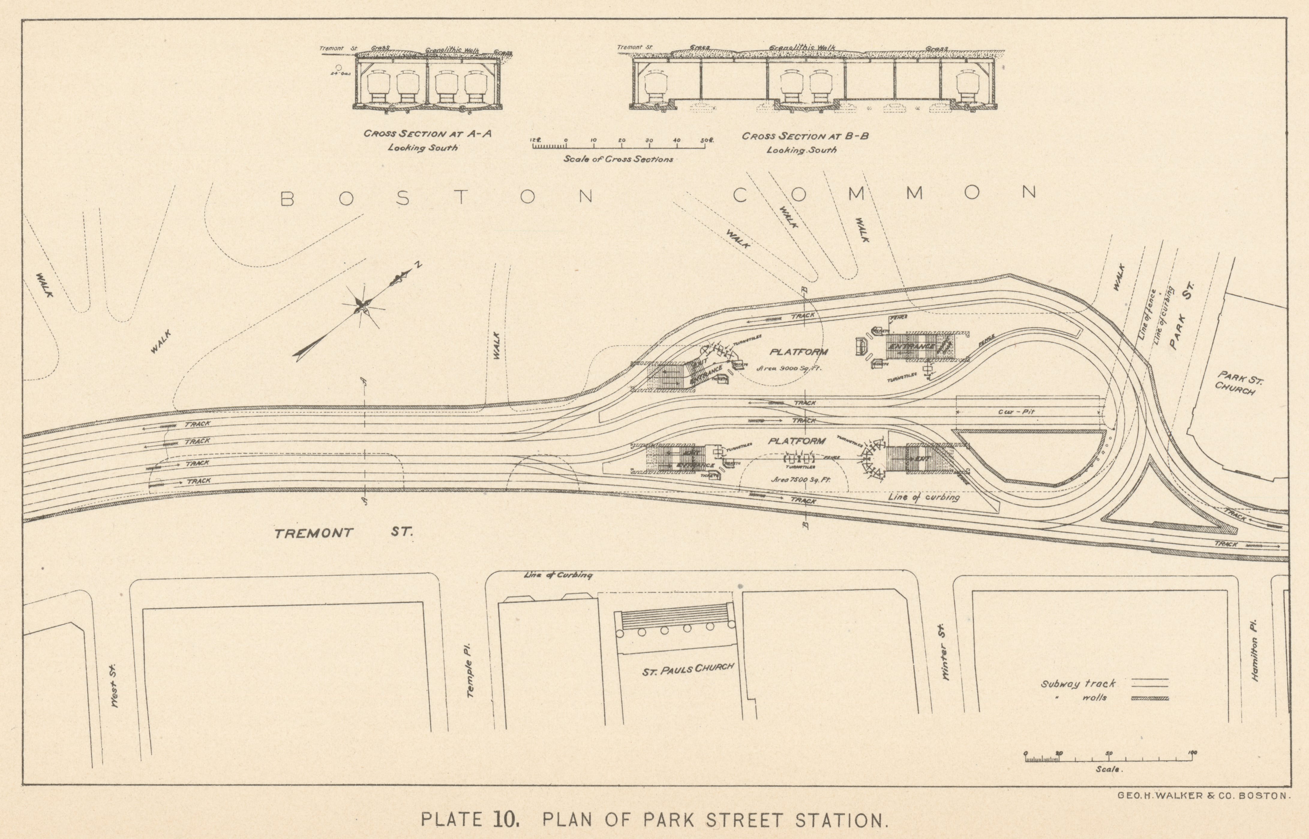
The first two subway stations to open to the public were Boylston Street VC2.4 and Park Street, VC2.6 with service commencing on the morning of September 1, 1897. When complete, the Tremont Street Subway’s tunnels allowed a forty percent increase in streetcar traffic passing through downtown Boston. A ten to twenty minute trip on surface streets was reduced to less than eight minutes.
VC2.4
“Plate 8” from “Fourth Annual Report of the Boston Transit Commission”
Boston Transit Commission
1898
WardMaps LLC
VC2.6
“Plate 10” from “Fourth Annual Report of the Boston Transit Commission”
Boston Transit Commission
1898
WardMaps LLC