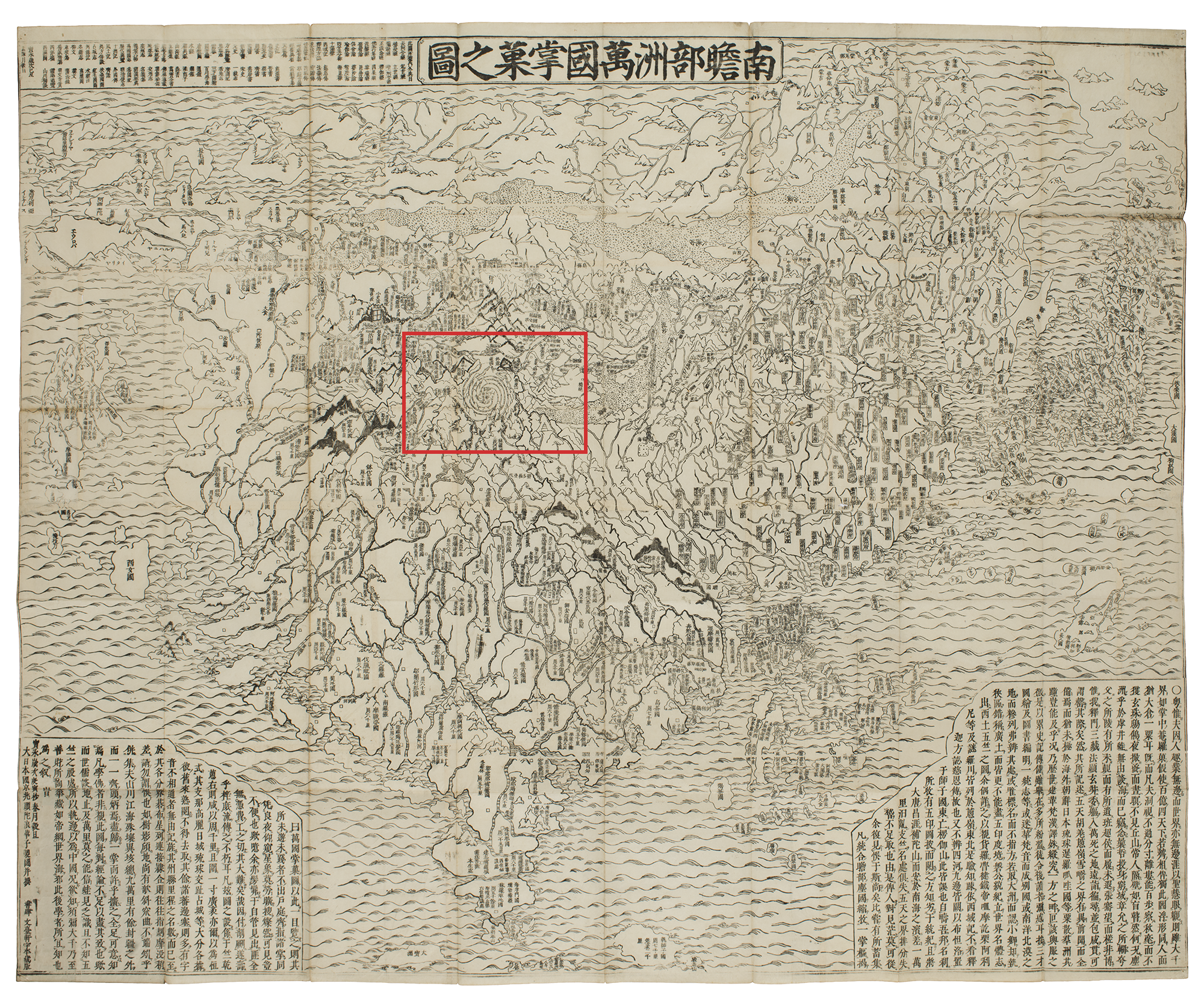
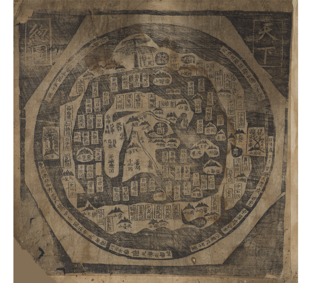
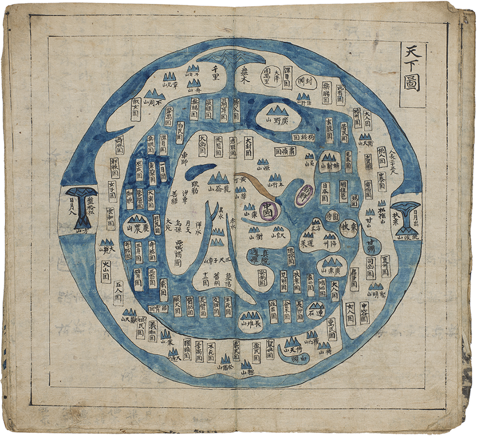
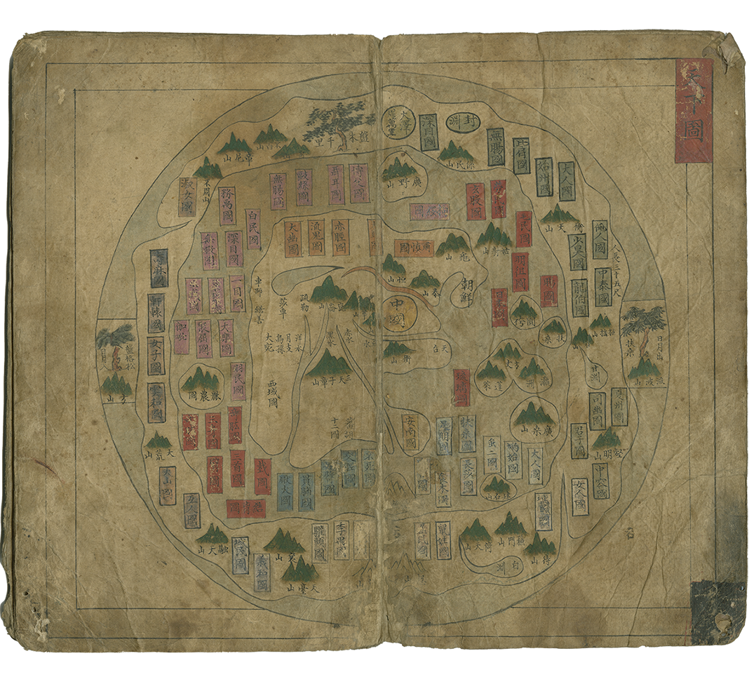
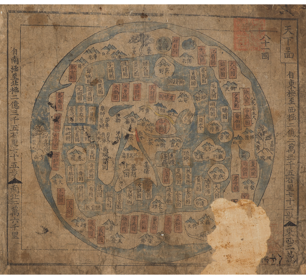
Map of the World (Cheonhado 天 下 圖)
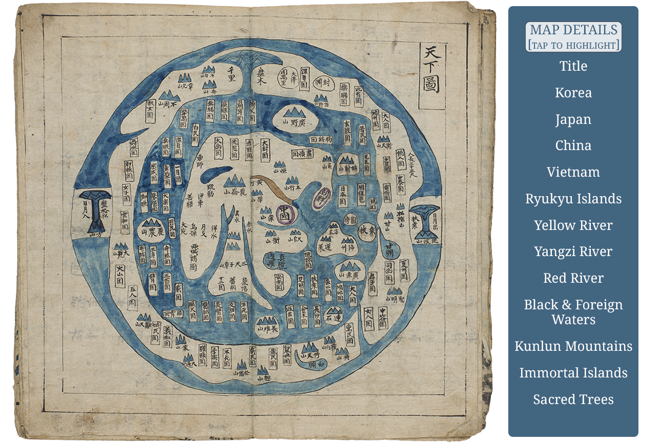
Unique in world cartography the Map of the World (commonly titled, as here, and referred to as cheonhado 天下圖, literally Map of All under Heaven) is the first map of the yeojido map narrative of these atlases. Comprised of mythical, imagined, as well as real toponyms and constructs from a variety of sources, the overall presentation is unlike any other in the world. This type of Cheonhado has been called a “circular map” or a “wheel map,” as popularized by the modern cartographer Yi Chan. The origins of the “wheel” Cheonhado and in particular, its unique cartographic configuration, are still unclear. There are a number of sources to consider when discussing these maps. This type of circular map may have been made as a result of the new perception of the world as round. European globes and maps with their graticules and hemispheres presented compelling concepts. As can be found in other maps of the period in East Asia, when cartographers were challenged by new European concepts or by issues of national identity, looking to the past was a successful method for satisfying consumption to a general public. This type of map is thus anchored in ancient map making traditions associated with imagined and mythical geographies as well as, at the same time, real geographies.
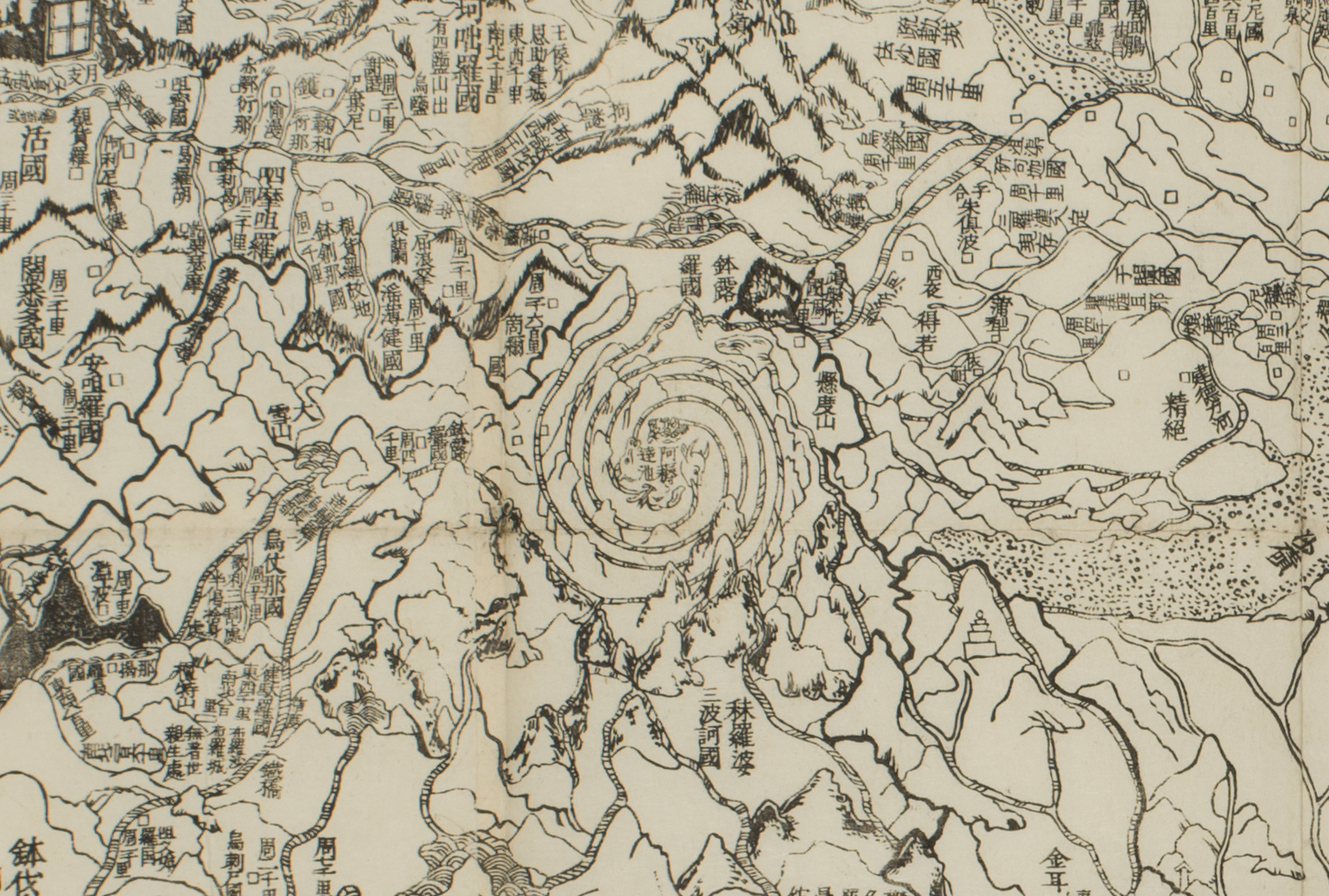
One likely conceptual source for the “wheel” Cheonhado derives from a tradition of mapmaking focused on Indian and Chinese Buddhist Maps of the World from as early as the seventh century. There are a number of Buddhist Sanskrit maps of the physical dimension or earthly plane of the Buddhist world known as Jambudvipa (c. Nanshanbuzhou, j. Nansenbushu), literally “Island of the Jambu Tree,” that could have been possible sources. An example in the MacLean Collection is the Nansenbushu Bankoku Shoku no zu (Map of All the Countries of the Jambudvipa) compiled by the Japanese monk Hotan (1654-1738) and dated 1710.
Some of the principles and places associated with Daoism, a native Chinese religion, philosophy and way of life with origins in the 6th century BCE, can be found in the cheonhado. In the southeast quadrant of the inner sea are located the three Chinese Daoist islands of the immortals, depicted here as a single tri-lobe shaped island. They are Bangnae 蓬萊 (c. Penglai), Bangjang 方丈 (c. Fangzhang) and Yeongju 瀛洲 (c. Yingzhou). And as many as seventeen Daoist toponyms can be found as derived from texts such as the Dongtian fudi yuedu mingshanji (Records of Grotto Paradises, Sacred Mountains and Rivers). There are other possible Daoist influences found in some alternative map titles on the cheonhado themselves, like Geon’gondo 乾坤圖 or Daeguekdo 太極圖 both of which have Daoist implications, the first refers to the first and last of the eight trigrams 八卦 (c. bagua) of the Yijing 易 經 (Book of Changes) which when placed together conceptually manifest the top and bottom halves of the circular universe. The eight sides of the octagon surrounding some of the Cheonhado are symbolic of the eight directions of the eight trigrams. The second referencing the daegue or “supreme ultimate” title also comes from the Daoist concept of the moment of singularity before the creation and separation of yin and yang. Configurations of mountains and sacred trees, the Busang tree on Mount Yupa to the east while to the west is shown the Bangyeoksong pine tree on Mount Bang, are positioned as places where the sun and moon rise and fall respectively (as indicated in a note on the map), standard symbols of yin and yang. Although the origins of the trees as matched to these mountains as well as their placement on these maps is still unclear they do add a mystical and perhaps Daoist magical quality to the maps.
The Shanhaijing (Mountains and Seas Classic) was an ancient Chinese classic finished during the Western Han dynasty (206 – 9 BCE), originally written in three sections. The first section described actual places in a sino-centric arrangement while the following two sections were mostly imaginary places. Its use as a primary source for the “wheel” Cheonhado map is confirmed in two ways. First, by the overall circular structure, as although each version of the “wheel” Cheonhado differs in detail, the general construct, as specifically described in the Shanhai jing, is the same throughout them all. This map consists of an inner continent surrounded by the ring of an inner sea which is surrounded by an outer continent all with place names contained therein. This is then surrounded by an outer sea that bears no name nor has any places named within it. To the north, in the outer land ring, is found the “thousand-li coil tree.” Two trees, depicted to the right and left (east and west respectively) and adjacently attached to the outer land ring, are the places where the sun and moon rise and set. To the east is shown the Busang tree on Mount Yupa while to the west is shown the Bangyeoksong pine tree on Mount Bang. The Shanhaijing as a primary source is second confirmed by the described fabled and mythical inhabitants and specific places of an imagined geography in the four cardinal directions. In general, the directional specificity described in the Shanhaijing is matched on the Cheonhado maps, i.e. places in the north are found in the north. As many as 143 toponyms listed on “wheel” Cheonhado can be found in the Shanhaijing, as well as from other Chinese classics, histories, and Daoist texts. The Shanhaijing accounts for 72% of those and comprise the mythical or imagined toponyms found mostly in the outer ring, whereas the inner continent sources Chinese classics and histories and thus represents the “real.” It should be noted that in China itself there was never a tradition of map production based on the Shanhaijing making its conceptual and geographical use in Korean Cheonhado unique in East Asia and the world.
Another ancient cosmological consideration of the round format of the “wheel” Cheonhado map is the ancient Chinese “round heaven, square earth” 天圓地方 (c. tianyuan difang, k. cheonweon jibang) construct. Conceptually, since at least the Han dynasty in China, the terrestrial world was considered a large square shaped continent surrounded by seas on its four sides, while the celestial world was a circle or sphere surrounding it, thus the creation of a four-character term in Chinese. This conceptual cosmology in not uniquely Chinese or East Asian but can be found throughout numerous ancient worlds. Conceptually then the outer circular shape of the map then represents heaven or the sky rather than the shape of the world. The squared inner continent could then be considered to be surrounded by a squared outer continent within this conceptual framework. This cosmological consideration is confirmed with the examples of the cheonhado that are surrounded by the octagonal shape representing the eight trigrams 八卦 (bagua), and eight directions, of the Yijing 易 經 (Book of Changes).
Most of the toponyms around the outer continental ring, but not all, are mythical or imaginary coming primarily from the Shanhaijing. The inner continent of the map however has a number of real toponyms. China, labeled Zhongguo 中國 (literally “Central Kingdom”) is located centrally with Korea, labeled Joseon 朝鮮 (name of the Joseon dynasty [1398-1910]) adjacent, with both given here the same status of a purple ring around the name. Although China is central to the conceptual framework of East Asia, this map positions Korea in a visually equated and highlighted purple ring. Japan 日本, Ryukyu (Islands) 琉球 and Vietnam 安南 (Annam, the historical Chinese toponym for Vietnam) are the other “real” countries as named in rectangular boxes. In addition, there are a number of well-known mountains and rivers indicated. Mountains are indicated with a mountain symbol, similar to the early Chinese mountain character of two peaks flanking a central taller peak, and the name. The rivers include the Yellow River, the Yangzi River and the Red River.
The MacLean Collection Map Library has five atlases and numerous single sheets from atlases. As can be seen here with comparative examples of “wheel” Cheonhado the general visual presentation of compositional elements is nearly the same throughout these particular maps with some minor notable differences. These maps were either black on white or multi-colored, as manuscripts or woodblock prints.