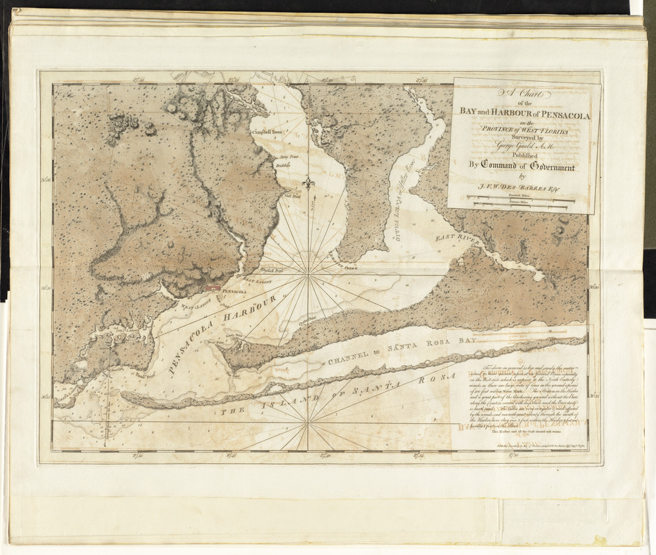
A chart of the bay and harbour of Pensacola in the Province of West Florida
This map is also available in American Revolutionary Geographies Online (ARGO), a collections portal especially built for material relating to the American Revolutionary War Era. Visit ARGO to learn more about this item and explore the historical geography of North America in the late eighteenth century.
Item Information
- Title:
- A chart of the bay and harbour of Pensacola in the Province of West Florida
- Creator:
- Gauld, George
- Contributor:
- Des Barres, Joseph F. W. (Joseph Frederick Wallet), 1722-1824
- Name on Item:
-
Surveyed by George Gauld, A.M.
- Date:
-
1780
- Format:
-
Maps/Atlases
- Location:
- George Washington's Mount Vernon
- Collection (local):
-
Richard H. Brown Revolutionary War Map Collection at Mount Vernon
- Subjects:
-
Harbors--Florida--Pensacola--Maps--Early works to 1800
Nautical charts--Florida--Pensacola Bay--Early works to 1800
Pensacola Bay (Fla.)--Maps--Early works to 1800
- Places:
-
Escambia (county)Pensacola
- Extent:
- 1 map : col. ; 50 x 71 cm.
- Terms of Use:
-
No known copyright restrictions.
This work is licensed for use under a Creative Commons Attribution Non-Commercial Share Alike License (CC BY-NC-SA).

- Publisher:
-
[London] :
J.F.W. Des Barres
- Scale:
-
Scale ca. 1:64,000
- Language:
-
English
- Catalog Record:
-
MVLA record
- Notes:
-
Relief shown by hachures and shading. Depths shown by soundings.
Includes text.
- Identifier:
-
06_01_010118
- LCCN:
-
77693968

![[A map of part of Pennsylvania & Maryland intended to shew, at one view, the several places proposed for opening a communication between the waters of the Delaware & Chesopeak Bays]](https://bpldcassets.blob.core.windows.net/derivatives/images/commonwealth:z603vt12v/image_thumbnail_300.jpg)
