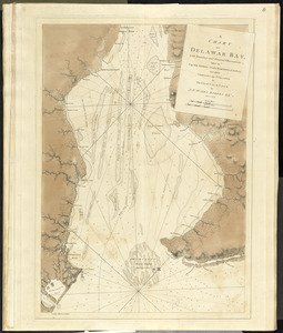
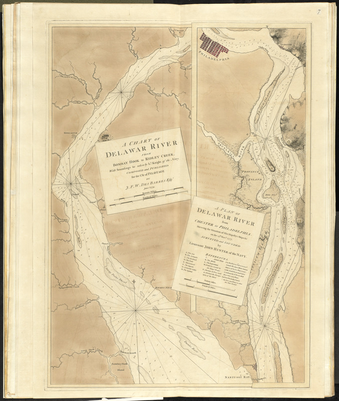
A chart of Delawar River from Bombay Hook to Ridley Creek, with soundings &c taken by Lt. Knight of the Navy
This map is also available in American Revolutionary Geographies Online (ARGO), a collections portal especially built for material relating to the American Revolutionary War Era. Visit ARGO to learn more about this item and explore the historical geography of North America in the late eighteenth century.
Item Information
- Title:
- A chart of Delawar River from Bombay Hook to Ridley Creek, with soundings &c taken by Lt. Knight of the Navy
- Creator:
- Des Barres, Joseph F. W. (Joseph Frederick Wallet), 1722-1824
- Contributor:
- Knight, John
- Contributor:
- Hunter, John, 1737-1821
- Name on Item:
-
Composed and published for use of pilotage by J.F.W. Des Barres.
- Date:
-
1779
- Format:
-
Maps/Atlases
- Location:
- George Washington's Mount Vernon
- Collection (local):
-
Richard H. Brown Revolutionary War Map Collection at Mount Vernon
- Subjects:
-
Nautical charts--Delaware River (N.Y.-Del. and N.J.)--Early works to 1800
Delaware River (N.Y.-Del. and N.J.)--Maps--Early works to 1800
- Places:
-
Delaware River
- Extent:
- 1 map : col. ; 76 x 54 cm.
- Terms of Use:
-
No known copyright restrictions.
This work is licensed for use under a Creative Commons Attribution Non-Commercial Share Alike License (CC BY-NC-SA).

- Publisher:
-
[London] :
J.F.W. Des Barres
- Edition:
- 3rd state
- Scale:
-
Scale ca. 1:75,000
- Language:
-
English
- Catalog Record:
-
MVLA record
- Notes:
-
Depths shown by soundings.
Includes "A plan of Delawar River from Chester to Philadelphia, shewing the situation of His Majesty's ships & c on the 15th Novr. 1777. Surveyed and sounded by Lieutenant John Hunter of the Navy," ca. 1:29,000, and index to defenses.
- Identifier:
-
06_01_010112
- LCCN:
-
75696335