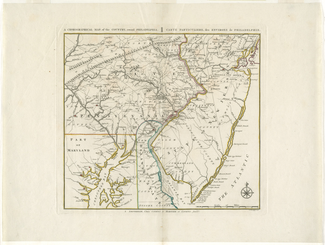
A chorographical map, of the country, round Philadelphia = : carte particuliere, des environs de Philadelphie
This map is also available in American Revolutionary Geographies Online (ARGO), a collections portal especially built for material relating to the American Revolutionary War Era. Visit ARGO to learn more about this item and explore the historical geography of North America in the late eighteenth century.
Item Information
- Title:
- A chorographical map, of the country, round Philadelphia = : carte particuliere, des environs de Philadelphie
- Title (alt.):
-
Carte particuliere des environs de Philadelphie
- Creator:
- Klockhoff, H. (Hendrik)
- Publisher:
- Covens et Mortier et Covens, junior
- Name on Item:
-
H. Klockhoff sculps.
- Date:
-
[1780?–1789?]
- Format:
-
Maps/Atlases
- Location:
- George Washington's Mount Vernon
- Collection (local):
-
Richard H. Brown Revolutionary War Map Collection at Mount Vernon
- Subjects:
-
Middle Atlantic States--History--Revolution, 1775-1783--Maps--Early works to 1800
- Places:
-
Middle Atlantic (area)
- Extent:
- 1 map : hand col. ; 29 x 33 cm.
- Terms of Use:
-
No known copyright restrictions.
This work is licensed for use under a Creative Commons Attribution Non-Commercial Share Alike License (CC BY-NC-SA).

- Publisher:
-
Amsterdam :
Chéz Covens et Mortier, et Covens, junior
- Scale:
-
Scale [ca. 1:790,000]
- Language:
-
English
French
- Catalog Record:
-
MVLA record
- Notes:
-
Relief shown pictorially.
Shows "Genl. Howe's track" from Elk River to Philadelphia, "Genl. Washington's track," and "Grand American Winter Camp, Jan. 1778" at Valley Forge.
Shows most of New Jersey and parts of Maryland, Pennsylvania, and Delaware. BPL
- Identifier:
-
06_01_008216


![[A map of part of Pennsylvania & Maryland intended to shew, at one view, the several places proposed for opening a communication between the waters of the Delaware & Chesopeak Bays]](https://bpldcassets.blob.core.windows.net/derivatives/images/commonwealth:z603vt12v/image_thumbnail_300.jpg)
