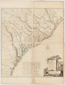
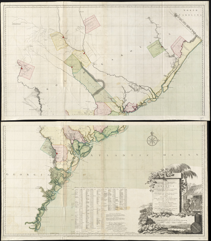
A map of South Carolina and a part of Georgia : containing the whole sea-coast; all the islands, inlets, rivers, creeks, parishes, townships, boroughs, roads, and bridges; as also, several plantations, with their proper boundary-lines, their names, and the names of their proprietors
This map is also available in American Revolutionary Geographies Online (ARGO), a collections portal especially built for material relating to the American Revolutionary War Era. Visit ARGO to learn more about this item and explore the historical geography of North America in the late eighteenth century.
Item Information
- Title:
- A map of South Carolina and a part of Georgia : containing the whole sea-coast; all the islands, inlets, rivers, creeks, parishes, townships, boroughs, roads, and bridges; as also, several plantations, with their proper boundary-lines, their names, and the names of their proprietors
- Description:
-
De Brahm immigrated to the colonies from Germany in 1751 and became a surveyor in Georgia in 1754. He created this map of South Carolina and Georgia in 1757 using scientific topographical surveys. The economy of this region thrived on rice, indigo, and cotton and depended on the labor of slaves. New England slave owners tended to own a few slaves, but Southern plantations depended on a larger enslaved labor force. The cartouche in the bottom right features a scene of slaves at work. After the French and Indian War, De Brahm supervised the British coastal survey for the southern district.
- Creator:
- De Brahm, John Gerar William, 1717-ca. 1799
- Contributor:
- Bull, William, 1710-1791
- Publisher:
- Jefferys, Thomas, d. 1771
- Name on Item:
-
composed from surveys taken by the Hon. William Bull, Esq., Lieutenant Governor, Captain Gascoign, Hugh Bryan, Esq; and the author William De Brahm ; engraved by Thomas Jeffrerys.
- Date:
-
1757
- Format:
-
Maps/Atlases
- Location:
- George Washington's Mount Vernon
- Collection (local):
-
Richard H. Brown Revolutionary War Map Collection at Mount Vernon
- Subjects:
-
Real property--South Carolina--Maps--Early works to 1800
Real property--Georgia--Maps--Early works to 1800
South Carolina--Administrative and political divisions--Maps--Early works to 1800
Georgia--Administrative and political divisions--Maps--Early works to 1800
- Places:
-
Georgia
South Carolina
- Extent:
- 1 map on 2 sheets : hand col. ; 131 x 119 cm., on sheets 72 x 125 cm.
- Terms of Use:
-
No known copyright restrictions.
This work is licensed for use under a Creative Commons Attribution Non-Commercial Share Alike License (CC BY-NC-SA).

- Publisher:
-
London :
T. Jefferys
- Scale:
-
Scale [ca. 1:318,000]
- Language:
-
English
- Catalog Record:
-
MVLA record
- Notes:
-
Relief shown by hachures.
Includes indexes of propietors of land in South Carolina and Georgia.
Decorative title cartouche depicting vegetation, manufactured products, and workers.
"To the Right Honourable George Dunk, Earl of Halifax ..."
This map can be viewed as a georeferenced overlay in an interactive application made especially for We Are One: Mapping America's Road from Revolution to Independence http://d2o8owo4k087al.cloudfront.net/index.html?mapId=38.
- Notes (exhibitions):
-
Exhibited: "We Are One: Mapping America's Road from Revolution to Independence" organized by the Norman B. Leventhal Map Center at the Boston Public Library, 2015.
- Identifier:
-
06_01_008136