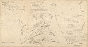
Dto de Baton Rouge
This map is also available in American Revolutionary Geographies Online (ARGO), a collections portal especially built for material relating to the American Revolutionary War Era. Visit ARGO to learn more about this item and explore the historical geography of North America in the late eighteenth century.
Item Information
- Title:
- Dto de Baton Rouge
- Creator:
- Pintado, Vicente Sebastián, 1774-1829
- Date:
-
[ca. 1799]
- Format:
-
Maps/Atlases
Manuscripts
- Location:
- Library of Congress Geography and Map Division
- Collection (local):
-
Library of Congress Collection
- Subjects:
-
Real property--Louisiana--East Baton Rouge Parish--Maps--Early works to 1800
East Baton Rouge Parish (La.)--Maps--Early works to 1800
Manuscript maps
- Places:
-
East Baton Rouge (county)
- Extent:
- 1 ms. map ; on sheet 39 x 47 cm.
- Terms of Use:
-
No known copyright restrictions.
This work is licensed for use under a Creative Commons Attribution Non-Commercial Share Alike License (CC BY-NC-SA).

- Scale:
-
Scale not given
- Language:
-
Spanish
- Catalog Record:
-
https://lccn.loc.gov/2013585037
- Notes:
-
Cadastral map; unfinished.
Relief shown by hachures and rock drawings.
Pen-and-ink and pencil.
Watermarks: W Elgar 1797 and horn in a shield surmounted by a crown over the letters WE.
From the papers of Vicente Sebastián Pintado.
Described in: Vicente Sebastián Pintado, Surveyor General of Spanish West Florida, 1805-17 : the man and his maps / by John R. Hébert. Imago mundi, v. 39, pp. 50-72. 1987. p. 64, no. 27.
- Notes (citation):
-
LC Luso-Hispanic World, 917
- Identifier:
-
lh000917


![Armstrong C[ount]y](https://bpldcassets.blob.core.windows.net/derivatives/images/commonwealth:q524ng353/image_thumbnail_300.jpg)