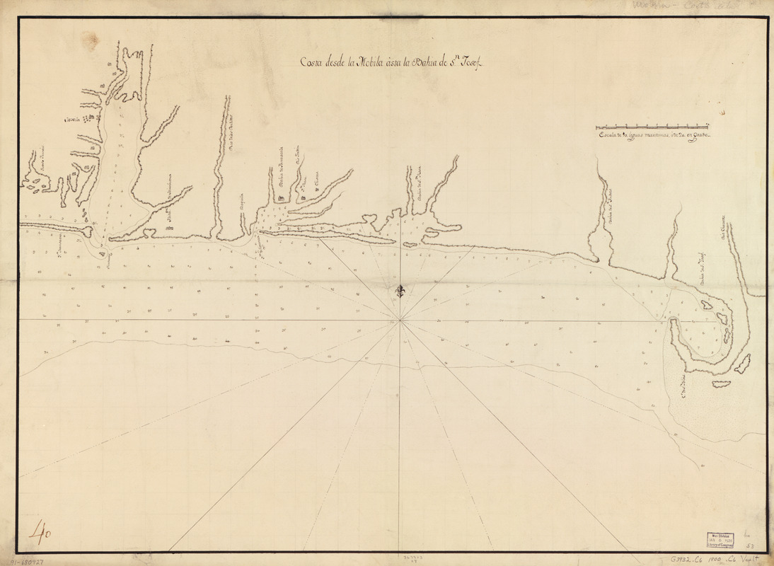
Costa desde la Mobila asta la Bahía de Sn. Josef
This map is also available in American Revolutionary Geographies Online (ARGO), a collections portal especially built for material relating to the American Revolutionary War Era. Visit ARGO to learn more about this item and explore the historical geography of North America in the late eighteenth century.
Item Information
- Title:
- Costa desde la Mobila asta la Bahía de Sn. Josef
- Date:
-
[ca. 1800]
- Format:
-
Maps/Atlases
Manuscripts
- Location:
- Library of Congress Geography and Map Division
- Collection (local):
-
Library of Congress Collection
- Subjects:
-
Gulf Coast (Fla.)--Maps, Manuscript--Early works to 1800
Coasts--Florida--Maps--Early works to 1800
Gulf Coast (Ala.)--Maps, Manuscript--Early works to 1800
Coasts--Alabama--Maps--Early works to 1800
Gulf Coast (U.S.)--Maps, Manuscript--Early works to 1800
Coasts--Gulf States--Maps--Early works to 1800
Manuscript maps--Early works to 1800
- Places:
-
Florida
Alabama
- Extent:
- 1 map : ms. ; 51 x 71 cm.
- Terms of Use:
-
No known copyright restrictions.
This work is licensed for use under a Creative Commons Attribution Non-Commercial Share Alike License (CC BY-NC-SA).

- Scale:
-
Scale [ca. 1:632,500]
- Language:
-
Spanish
- Catalog Record:
-
https://lccn.loc.gov/91680927
- Notes:
-
Also shows fort and settlements.
Depths shown by soundings.
Watermark: J. Whatman.
Pen-and-ink.
Mounted on cloth backing.
Printed label describing the map mounted on verso.
Annotated in brown ink in lower left corner: 40.
Maggs number annotated in pencil in lower right corner: 53.
Order number annotated in pencil in lower margin: 367903/27.
- Notes (citation):
-
LC Luso-Hispanic World, 824
- Identifier:
-
lh000824

![Chart of the sea coast from latitude 27⁰00ʹ00ʺ to 27⁰20ʹ00ʺ, with Little Inlet & River into Hillsborough River ; Chart of the sea coast from latitude 26⁰40ʹ00ʺ to [27⁰]00ʹ00ʺ, the Leech Shoal & Hillsborough River](https://bpldcassets.blob.core.windows.net/derivatives/images/commonwealth:q524nd97p/image_thumbnail_300.jpg)


