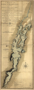
S[i]r: This is minuts of the fort at Crown Point and of the redouts built round it; which I took on the mountain to the west of Crown Point abt. a miles distance
![S[i]r: This is minuts of the fort at Crown Point and of the redouts built round it; which I took on the mountain to the west of Crown Point abt. a miles distance](https://bpldcassets.blob.core.windows.net/derivatives/images/commonwealth:q524nd85w/image_access_800.jpg)
This map is also available in American Revolutionary Geographies Online (ARGO), a collections portal especially built for material relating to the American Revolutionary War Era. Visit ARGO to learn more about this item and explore the historical geography of North America in the late eighteenth century.
Item Information
- Title:
- S[i]r: This is minuts of the fort at Crown Point and of the redouts built round it; which I took on the mountain to the west of Crown Point abt. a miles distance
- Creator:
- Rogers, Robert, 1731-1795
- Contributor:
- Johnson, William, 1715-1774
- Name on Item:
-
S[i]r yr. servant ... Robert Rodgers. To Genrl. Johnson
- Date:
-
[1755]
- Format:
-
Maps/Atlases
Manuscripts
- Location:
- Library of Congress Geography and Map Division
- Collection (local):
-
Library of Congress Collection
- Subjects:
-
Fortification--New York (State)--Crown Point--Maps--Early works to 1800
Crown Point (N.Y.)--History--French and Indian War, 1754-1763--Maps--Early works to 1800
Crown Point (N.Y.)--Buildings, structures, etc--Maps--Early works to 1800
Manuscript maps--Early works to 1800
- Places:
-
Essex (county)Crown Point
- Extent:
- 1 manuscript map 37 x 30 cm.
- Terms of Use:
-
No known copyright restrictions.
This work is licensed for use under a Creative Commons Attribution Non-Commercial Share Alike License (CC BY-NC-SA).

- Scale:
-
Scale ca. 1:6,000
- Language:
-
English
- Catalog Record:
-
https://lccn.loc.gov/73691808
- Notes:
-
Manuscript, pen-and-ink.
Has watermarks.
- Notes (date):
-
This date is inferred.
- Identifier:
-
ar303600