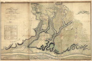
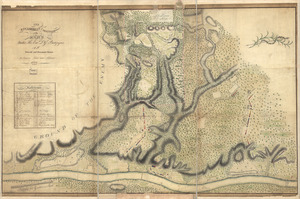
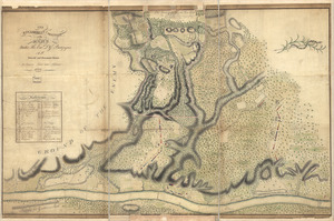
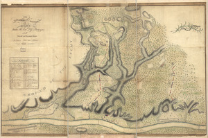
Plan of the encampment and position of the army under His Excelly. Lt. General Burgoyne : at Swords House on Hudson's River on Septr. 17th, with the positions of that part of the army engaged on the 19th Septr. 1777

This map is also available in American Revolutionary Geographies Online (ARGO), a collections portal especially built for material relating to the American Revolutionary War Era. Visit ARGO to learn more about this item and explore the historical geography of North America in the late eighteenth century.
Item Information
- Title:
- Plan of the encampment and position of the army under His Excelly. Lt. General Burgoyne : at Swords House on Hudson's River on Septr. 17th, with the positions of that part of the army engaged on the 19th Septr. 1777
- Creator:
- Wilkinson, William Cumberland
- Name on Item:
-
Drawn by W. C. Wilkinson
- Date:
-
[1777?]
- Format:
-
Maps/Atlases
Manuscripts
- Location:
- Library of Congress Geography and Map Division
- Collection (local):
-
Library of Congress Collection
- Subjects:
-
Saratoga Campaign, N.Y., 1777--Maps, Manuscript--Early works to 1800
Saratoga County (N.Y.)--History--Revolution, 1775-1783
- Places:
-
Saratoga (county)
- Extent:
- 1 manuscript map 32 x 38 cm.
- Terms of Use:
-
No known copyright restrictions.
This work is licensed for use under a Creative Commons Attribution Non-Commercial Share Alike License (CC BY-NC-SA).

- Scale:
-
Scale ca. 1:14,400
- Language:
-
English
- Catalog Record:
-
https://lccn.loc.gov/gm71000662
- Notes:
-
Title from engraved copy published by William Faden, 1780. (Faden 68).
Manuscript, pen-and-ink.
Relief shown by hachures.
- Notes (citation):
-
LC Maps of North America, 1750-1789, 1180
- Identifier:
-
ar118000