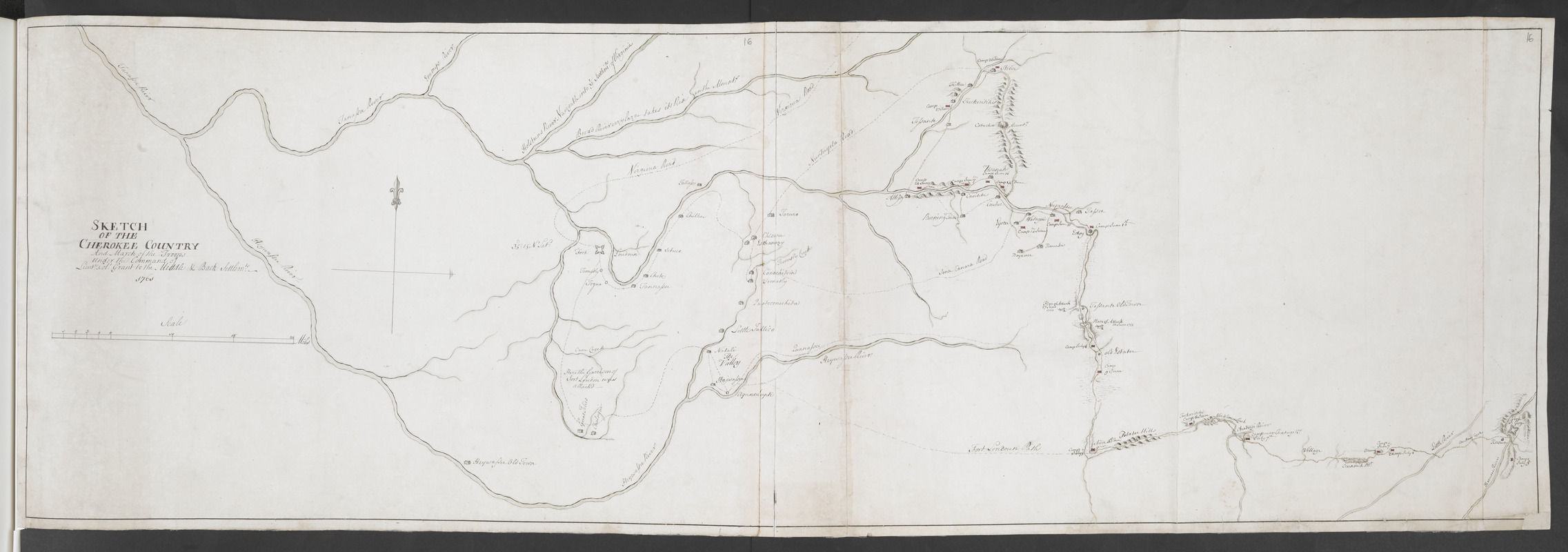
SKETCH OF THE CHEROKEE COUNTRY And March of the Troops Under the Command of Luet. Col. Grant to the Middle & Back Settlem:ts. 1761
This map is also available in American Revolutionary Geographies Online (ARGO), a collections portal especially built for material relating to the American Revolutionary War Era. Visit ARGO to learn more about this item and explore the historical geography of North America in the late eighteenth century.
Item Information
- Title:
- SKETCH OF THE CHEROKEE COUNTRY And March of the Troops Under the Command of Luet. Col. Grant to the Middle & Back Settlem:ts. 1761
- Cartographer:
- Stuart, John, 1718-1779
- Associated name:
- Grant, James, 1720-1806
- Former owner:
- Amherst, Jeffery Amherst, Baron, 1717-1797
- Former owner:
- Royal United Services Institute for Defence and Security Studies
- Date:
-
1760
- Format:
-
Maps/Atlases
- Location:
- British Library
- Collection (local):
-
British Library Collection
- Subjects:
-
Cherokee Indians--Maps, Manuscript--Early works to 1800
Fort Prince George (S.C. : Fort)--Maps, Manuscript--Early works to 1800
Fort Loudoun (Tenn. : Fort)--Maps, Manuscript--Early works to 1800
Cherokee Foothills Scenic Highway (S.C.)--Maps, Manuscript--Early works to 1800
- Places:
-
Fort Prince George
Monroe (county)Fort Loudon
- Extent:
- 1 map on 2 sheets : joined, manuscript pen and ink with watercolour ; 108 x 35 cm
- Terms of Use:
-
No known copyright restrictions.
This work is licensed for use under a Creative Commons Attribution Non-Commercial Share Alike License (CC BY-NC-SA).

- Publisher:
-
[Place of production not identified] :
[John Stuart]
- Scale:
-
Scale approximately 1:190,000
- Language:
-
English
- Catalog Record:
-
http://searcharchives.bl.uk/IAMS_VU2:IAMS040-001999746
- Notes:
-
Cartographer attribution from previous British Library cataloguing (see Add. 14036.e.)
Relief shown pictorially.
Shows title at centre left with scale bar below.
Shows a decorative compass arrow orienting north to the top of the map.
Shows rivers, roads and forts (Fort Prince George and Fort Loudoun).
Shows camps and places of attack (during Anglo-Cherokee War) with dates on the map.
Copy at Add Ms 57,714.16. Bound in R.U.S.I. Vol LXXIX. Shows manuscript addition of "16" in pencil at upper right. Laid on archival tissue. Green circular label to verso shows "4". White label to verso shows "DRAWER 29 SECTION 3". Blue label to verso shows "A 29/45" (and repeated in pencil). Shows "A 68" in pencil to verso. Evidence of old folds. Paper watermark shows a fleur de lys within a shield with "LVG" beneath. Pressmark repeated to verso in pencil.
- Notes (date):
-
9999


