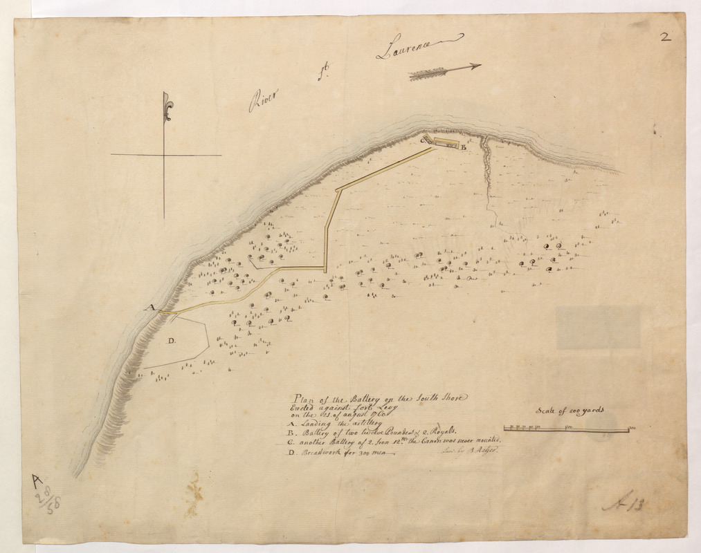
Plan of the Battery on the South Shore Erected against Fort Levy on the 21. of August 1760
This map is also available in American Revolutionary Geographies Online (ARGO), a collections portal especially built for material relating to the American Revolutionary War Era. Visit ARGO to learn more about this item and explore the historical geography of North America in the late eighteenth century.
Item Information
- Title:
- Plan of the Battery on the South Shore Erected against Fort Levy on the 21. of August 1760
- Surveyor:
- Ratzer, Bernard
- Former owner:
- Amherst, Jeffery Amherst, Baron, 1717-1797
- Former owner:
- Royal United Services Institute for Defence and Security Studies
- Name on Item:
-
Surv: by B. Ratzer.
- Date:
-
[ca. 1760]
- Format:
-
Maps/Atlases
- Location:
- British Library
- Collection (local):
-
British Library Collection
- Subjects:
-
Fortification--Ontario--Maps, Manuscript--Early works to 1800
Military art and science--Ontario--Maps, Manuscript--Early works to 1800
Fort Lévis (Ontario)--Maps, Manuscript--Early works to 1800
- Places:
-
Saint Lawrence (county)Chimney Island (island)
CanadaOntario (province)
- Extent:
- 1 map : manuscript pen and ink with watercolour ; 32 x 41 cm
- Terms of Use:
-
No known copyright restrictions.
This work is licensed for use under a Creative Commons Attribution Non-Commercial Share Alike License (CC BY-NC-SA).

- Publisher:
-
[Place of production not identified] :
Surv: by B. Ratzer,
- Scale:
-
Scale approximately 1:2,400
- Language:
-
English
- Catalog Record:
-
http://searcharchives.bl.uk/IAMS_VU2:IAMS040-001999737
- Notes:
-
Shows title at lower centre with lettered key (A-D) beneath. The key identifies the locations for "Landing the artillery, "Battery of two twelve Pounders & 2 Royals", "another Battery of 2. from 12.th the Canon was never mounted" and "Breastwork for 300 men".
A "Scale of 200 Yards" is shown at lower right.
A decorative compass arrow is shown in the "River S.t Lawrence" and orients north to the top of the map.
Consider Library and Archives of Canada, H3 1250, National Map Collection 0007763 referenced in "Two Ships - Two Flags: the Outaouaise/Williamson and the Iroquoise/Anson on Lake Ontario, 1759 -1761" by Robert J. Andrews with the note that "At General Jeffery Amherst's request, Lieutenant Bernard Ratzer of the 60th Regiment surveyed Fort Levy, which map Amherst included in his dispatch to William Pitt of 4 October 1760. On the map, Ratzer located the Iroquoise and the unfinished vessel side by side. The hulls appear to be identical in shape and size. See Library and Archives of Canada, H3 1250, National Map Collection 0007763" (page 42) against the manuscript addition to the verso of this map that it is "Opposite Fort William Augustus". Thus, the map seems to show British defences built at Fort Lévis (near present-day Johnstown) and not to be confused with British defences also built against Fort Pointe-de-Lévy (which later became the location for Fort de la Martinière, near Quebec City).
Copy at Add Ms 57,707.2. Bound in R.U.S.I. Vol LXXII. Shows manuscript addition of "A 13" in pencil at lower right and "A 28/58" at lower left. Shows manuscript addition of "2" in pencil at upper right. Laid on archival tissue. Green circular label to verso showing "1". White label to verso showing "DRAWER 28 SECTION 1". Blue label to the verso shows "A 28/58". Paper watermark shows Britannia (?) within a roundel. Manuscript addition to verso in pencil shows "Opposite Fort William Augustus".
- Notes (date):
-
9999


