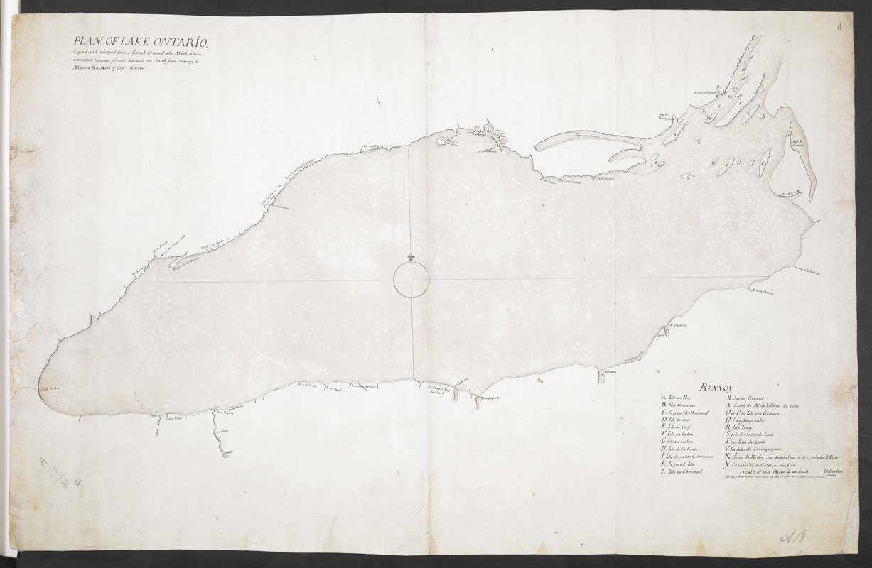
PLAN OF LAKE ONTARIO Copied and inlarged from a French Original, the North Shore corrected in some places, likewise the South from Oswego to Niagara by a Sketh of Cap. Sowers
This map is also available in American Revolutionary Geographies Online (ARGO), a collections portal especially built for material relating to the American Revolutionary War Era. Visit ARGO to learn more about this item and explore the historical geography of North America in the late eighteenth century.
Item Information
- Title:
- PLAN OF LAKE ONTARIO Copied and inlarged from a French Original, the North Shore corrected in some places, likewise the South from Oswego to Niagara by a Sketh of Cap. Sowers
- Cartographer:
- Brehm, Dietrich
- Surveyor:
- Sowers, Thomas
- Former owner:
- Amherst, Jeffery Amherst, Baron, 1717-1797
- Former owner:
- Royal United Services Institute for Defence and Security Studies
- Name on Item:
-
D: Brehm Lieut.
- Date:
-
[ca. 1760]
- Format:
-
Maps/Atlases
- Location:
- British Library
- Collection (local):
-
British Library Collection
- Subjects:
-
Fortification--Ontario, Lake (N.Y. and Ont.)--Maps, Manuscript--Early works to 1800
Military art and science--Ontario, Lake (N.Y. and Ont.)--Maps, Manuscript--Early works to 1800
Ontario, Lake (N.Y. and Ont.)--Maps, Manuscript--Early works to 1800
- Places:
-
Ontario, Lake
- Extent:
- 1 map : manuscript pen and ink with watercolour ; 49 x 76 cm
- Terms of Use:
-
No known copyright restrictions.
This work is licensed for use under a Creative Commons Attribution Non-Commercial Share Alike License (CC BY-NC-SA).

- Publisher:
-
[Place of production not identified] :
D: Brehm Lieut.,
- Scale:
-
Scale not given
- Language:
-
English
- Catalog Record:
-
http://searcharchives.bl.uk/IAMS_VU2:IAMS040-001999737
- Notes:
-
Date attributed from detail on the map; shows "Ruins of Frontenac" (destroyed in 1758) and "Where Fort Toronto stood" (Fort Toronto or Fort Rouillé was burned in 1759).
Shows title at upper left.
Shows lettered key (A-Y) at lower right identifying islands.
Refers to "a French Original" - perhaps René-Hippolyte Laforce's map (see Add Ms 57,707.10.).
Signed "D: Brehm Lieut;" at lower right.
Shows a route across the lake from Fort Niagara to "Where Fort Toronto stood".
Copy at Add Ms 57,707.11. Bound in R.U.S.I. Vol LXXII. Shows manuscript addition of "11" in pencil at upper right. Shows "A 27/31C" in pencil at lower left and "A 18" at lower right. Laid on archival tissue. Manuscript addition of "A 18" repeated to verso. Green circular label to verso showing "14". White label to verso showing "DRAWER 27 SECTION 3". Blue label to verso shows "A 27/31C".
- Notes (date):
-
9999

![[Lake Ontario]](https://bpldcassets.blob.core.windows.net/derivatives/images/commonwealth:hx11xz576/image_thumbnail_300.jpg)
![Lake Ontario & River S.t Laurence from the Lake to Fort William Augustus in Three Rivers, this was taken from a French Draft that was on Board the Prise Williamson belonging to Monsr La Broquerie [east sheet]](https://bpldcassets.blob.core.windows.net/derivatives/images/commonwealth:hx11z135r/image_thumbnail_300.jpg)
![Lake Ontario & River S.t Laurence from the Lake to Fort William Augustus in Three Rivers, this was taken from a French Draft that was on Board the Prise Williamson belonging to Monsr La Broquerie [middle sheet]](https://bpldcassets.blob.core.windows.net/derivatives/images/commonwealth:hx11z1379/image_thumbnail_300.jpg)
