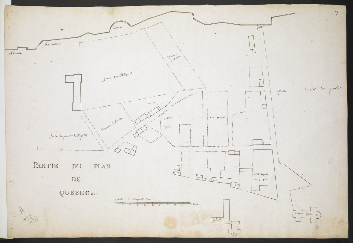
PARTIE DU PLAN DE QUEBEC
This map is also available in American Revolutionary Geographies Online (ARGO), a collections portal especially built for material relating to the American Revolutionary War Era. Visit ARGO to learn more about this item and explore the historical geography of North America in the late eighteenth century.
Item Information
- Title:
- PARTIE DU PLAN DE QUEBEC
- Associated name:
- Catalogne, Gédéon de, 1662-1729
- Former owner:
- Royal United Services Institute for Defence and Security Studies
- Date:
-
[1759]
- Format:
-
Maps/Atlases
- Location:
- British Library
- Collection (local):
-
British Library Collection
- Subjects:
-
Hospitals--Québec (Province)--Québec--Maps, Manuscript--Early works to 1800
Québec (Québec)--Maps, Manuscript--Early works to 1800
- Places:
-
CanadaQuébec
- Extent:
- 1 map : manuscript pen and ink over pencil ; 36 x 53 cm
- Terms of Use:
-
No known copyright restrictions.
This work is licensed for use under a Creative Commons Attribution Non-Commercial Share Alike License (CC BY-NC-SA).

- Publisher:
-
[Place of production not identified] :
[producer not identified]
- Scale:
-
Scale approximately 1:830
- Language:
-
French
- Catalog Record:
-
http://searcharchives.bl.uk/IAMS_VU2:IAMS040-001999734
- Notes:
-
Shows title at lower left.
Shows "Eschelle de Cinquante toises" at lower centre.
Shows the hospital - Hôtel-Dieu de Québec with surrounding gardens and cemetaries.
Shows adjacent lands belonging to "lepiné", "Duplessis" and "Gautier".
Shows "Nouvelles fortifications" to the north of the hospital.
Consider Gedeon de Catalogne as cartographer? Compare signed map Add Ms 57,706.1.
Copy at Add Ms 57,704.7. Bound in R.U.S.I. Vol LXIX. Shows manuscript addition of "7" in pencil at upper right. Shows manuscript addition of "A 28/85" in pencil at lower left. Laid on archival tissue. Green circular label to verso shows "30". White label to verso showing "DRAWER 28 SECTION 1". Blue label to verso shows "A 28/85".
- Notes (date):
-
9999
This date is inferred.

![[Map of Quebec and environs showing the position of the English and French troops]](https://bpldcassets.blob.core.windows.net/derivatives/images/commonwealth:hx11xz61s/image_thumbnail_300.jpg)
![[Map of the environs of Quebec showing the position of the English and French troops]](https://bpldcassets.blob.core.windows.net/derivatives/images/commonwealth:hx11xz690/image_thumbnail_300.jpg)