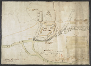
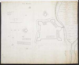
[Fort Bedford, on the Juniata Creek]
![[Fort Bedford, on the Juniata Creek]](https://bpldcassets.blob.core.windows.net/derivatives/images/commonwealth:hx11z402t/image_access_800.jpg)
This map is also available in American Revolutionary Geographies Online (ARGO), a collections portal especially built for material relating to the American Revolutionary War Era. Visit ARGO to learn more about this item and explore the historical geography of North America in the late eighteenth century.
Item Information
- Title:
- [Fort Bedford, on the Juniata Creek]
- Former owner:
- George, III, King of Great Britain, 1738-1820
- Donor:
- George, IV, King of Great Britain, 1762-1830
- Date:
-
1758
- Format:
-
Maps/Atlases
Manuscripts
- Location:
- British Library
- Collection (local):
-
British Library Collection
- Subjects:
-
Military art and science--Pennsylvania--Bedford--Maps, Mansucript--Early works to 1800
Fort Bedford (Bedford, Pa.)--Maps, Manuscript--Early works to 1800
United States--History--French and Indian War, 1754-1763--Maps, Manuscript--Early works to 1800
- Places:
-
Bedford (county)Bedford
- Extent:
- 1 map : manuscript pen and ink with watercolour ; 64 x 47 cm
- Terms of Use:
-
No known copyright restrictions.
This work is licensed for use under a Creative Commons Attribution Non-Commercial Share Alike License (CC BY-NC-SA).

- Scale:
-
Scale approximately 1:885
- Language:
-
English
- Catalog Record:
-
http://explore.bl.uk/BLVU1:LSCOP-ALL:BLL01004987653
- Notes:
-
Date attributed - Fort Bedford was built in 1758.
Relief shown by shading.
North oriented to the bottom of the map.
With a "Scale for the Plan" and a "Scale for the Profil" in feet at lower left.
"Section thro' A,B" shown lower centre and marked on the map. Scale approximately 1:240.
Shows "Juniata Creek".
Shows "Store-house", "Hospitals", "Suters Houses" (traders' houses) and "Penterarese's" (the buildings of Mr Pendergast, a settler - Stotz).
The unusual use of "Penterarese's" on this map is referenced in the April 1843 edition of the American Pioneer and in the September 21st 1906 edition of The Bedford Gazette.
This manuscript map could be the source for a printed map of Fort Bedford which appeared in "A SET of PLANS and FORTS IN AMERICA, Reduced from Actual Surveys", first published in 1763. A copy of the second edition of the work published by Mary Ann Rocque (1765) may be found in the King's Topographical Collection (118.a.22.). Letters from Mary Ann Rocque to Lord Bute, who advised George III's early collecting, are known to exist in the Mount Stuart archives (Peter Barber - Head of Cartographic and Topographic Materials at the British Library). The printed map repeats the labels from this manuscript, including the unusual use of "Penterarese's".
Titled "A drawn View of Fort Bedford in Pennsylvania" in the Catalogue of Maps, Prints, Drawings, etc., forming the geographical and topographical collection attached to the Library of his late Majesty King George the third, etc., London, 1829.
Titled 'A colored plan of Fort Bedford, on the Juniata Creek; drawn on a scale of 70 feet to an inch, with section on a scale of 20 feet to an inch: 1 f. 7 in. x 1 f. 1 1/2 in.' in the Catalogue of the manuscript maps, charts, and plans, and of the topographical drawings in the British Museum.
Fort Bedford located in present-day Bedford in Pennsylvania.

![[A colored map of the route between Albany and Oswego; drawn about 1756, on a scale of 2 miles to an inch]](https://bpldcassets.blob.core.windows.net/derivatives/images/commonwealth:hx11z3223/image_thumbnail_300.jpg)
![[A map of Fort Carillon and environs]](https://bpldcassets.blob.core.windows.net/derivatives/images/commonwealth:hx11z538d/image_thumbnail_300.jpg)
