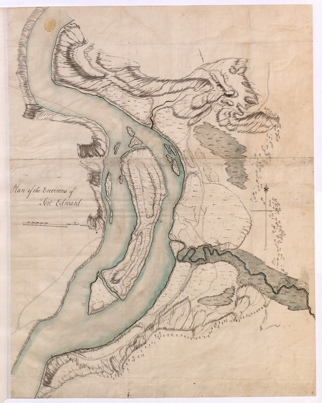
Plan of the Environs of Fort Edward
This map is also available in American Revolutionary Geographies Online (ARGO), a collections portal especially built for material relating to the American Revolutionary War Era. Visit ARGO to learn more about this item and explore the historical geography of North America in the late eighteenth century.
Item Information
- Title:
- Plan of the Environs of Fort Edward
- Former owner:
- George, III, King of Great Britain, 1738-1820
- Donor:
- George, IV, King of Great Britain, 1762-1830
- Date:
-
1756
- Format:
-
Maps/Atlases
Manuscripts
- Location:
- British Library
- Collection (local):
-
British Library Collection
- Subjects:
-
Fortification--New York (State)--Fort Edward--Maps, Manuscript--Early works to 1800
Military art and science--New York (State)--Fort Edward--Maps, Manuscript--Early works to 1800
Fort Edward (N.Y.)--Maps, Manuscript--Early works to 1800
United States--History--French and Indian War, 1754-1763--Maps, Manuscript--Early works to 1800
- Places:
-
Washington (county)Fort Edward
- Extent:
- 1 map on 2 sheets : joined, manuscript pen and ink with watercolour ; 58 x 45 cm
- Terms of Use:
-
No known copyright restrictions.
This work is licensed for use under a Creative Commons Attribution Non-Commercial Share Alike License (CC BY-NC-SA).

- Scale:
-
Scale approximately 1:4,800
- Language:
-
English
- Catalog Record:
-
http://explore.bl.uk/BLVU1:LSCOP-ALL:BLL01004987747
- Notes:
-
A date of about 1756 is attributed to this map as it does not show any construction on Rogers Island, where building took place in 1757 and 1758 - http://www.rogersisland.org/programs/HISTORY%20OF%20FORT%20EDWARD%20AND%20ROGERS%20ISLAND.pdf (viewed 2014).
Relief is shown by shading.
With a scale of "1000 Feet 400 to an Inch" beneath the title.
With a compass orienting north to the top of the map.
Titled "A drawn Plan of the Environs of Fort Edward" in the Catalogue of Maps, Prints, Drawings, etc., forming the geographical and topographical collection attached to the Library of his late Majesty King George the third, etc., London, 1829.
Titled 'A colored "plan of the environs of Fort Edward;" drawn about 1756, on a scale of 400 feet to an inch: 1 f. 11 in. x 1 f. 6 in.' in the Catalogue of the manuscript maps, charts, and plans, and of the topographical drawings in the British Museum.