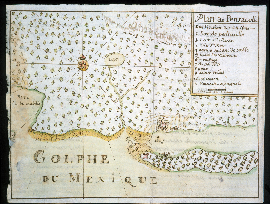
Plan de Pensacolle
This map is also available in American Revolutionary Geographies Online (ARGO), a collections portal especially built for material relating to the American Revolutionary War Era. Visit ARGO to learn more about this item and explore the historical geography of North America in the late eighteenth century.
Item Information
- Title:
- Plan de Pensacolle
- Title (alt.):
-
Plan de Pensacola
- Description:
-
Map of the Pensacola, Florida region illustrating the capture of Forts Pensacola and Santa Rosa by French forces in 1719. Keyed to 11 references, including the forts, Spanish ships, and an anchorage. From French army officer Dumont de Montigny's 1747 manuscript memoire of his experiences in Louisiana between 1715-1737.
- Creator:
- Dumont de Montigny
- Date:
-
[1747]
- Format:
-
Maps/Atlases
Manuscripts
- Location:
- Newberry Library
- Collection (local):
-
Edward E. Ayer Manuscript Map Collection
- Subjects:
-
Fortification--Florida--Pensacola--Maps--Early works to 1800
Manuscript maps--Early works to 1800
Pensacola (Fla.)--Maps--Early works to 1800
- Places:
-
FloridaEscambia (county)Pensacola
- Extent:
- 1 ms. map : hand col. ; 171 x 227 mm.
- Terms of Use:
-
No known copyright restrictions.
Contact host institution for more information.
- Scale:
-
Scale [ca. 1:533,000]
- Language:
-
French
- Catalog Record:
-
https://i-share-nby.primo.exlibrisgroup.com/permalink/01CARLI_NBY/i5mcb2/alma991477198805867
- Notes:
-
Note on verso: No. 3, page 57.
Pen-and-ink and watercolor (green, yellow, red).
No. 3 of 23 maps and drawings detached and bound together, from: Dumont de Montigny. Memoire de Lxx Dxx Officiere Ingenieur, contenant les evenemens qui se sont passés à la Louisiane depuis 1715 jusqu'a present [1747]
Photostat of related manuscript map in the Service Hydrographique archives in Paris, no. S.H.A. 138-9-6, forms part of the Louis C. Karpinski Map Collection (Newberry Library).
Ms. memoire adapted by Jean Baptiste Le Mascrier and published as Dumont de Montigny, Mémoires historiques sur la Louisiane. Paris: C.J.B. Bauche, 1753.
- Notes (date):
-
This date is inferred.
- Call #:
-
Ayer MS 257 map 3 (NLO)