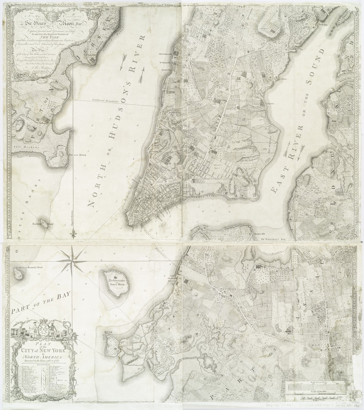
Plan of the city of New York in North America : surveyed in the years 1766 & 1767
This map is also available in American Revolutionary Geographies Online (ARGO), a collections portal especially built for material relating to the American Revolutionary War Era. Visit ARGO to learn more about this item and explore the historical geography of North America in the late eighteenth century.
Item Information
- Title:
- Plan of the city of New York in North America : surveyed in the years 1766 & 1767
- Creator:
- Ratzer, Bernard
- Engraver:
- Kitchin, Thomas, 1718-1784
- Publisher:
- Jefferys and Faden, London
- Name on Item:
-
B. Ratzer ; Thos. Kitchin, sculpt.
- Date:
-
1776
- Format:
-
Maps/Atlases
- Location:
- New York Public Library
- Collection (local):
-
Maps of New York City and State
- Subjects:
-
New York (N.Y.)--Maps--Early works to 1800
- Places:
-
New York
- Extent:
- 1 map : dissected and mounted on linen ; 101 x 90 cm., on sheet 121 x 90 cm.
- Terms of Use:
-
No known copyright restrictions.
This work is licensed for use under a Creative Commons Attribution Non-Commercial Share Alike License (CC BY-NC-SA).

- Publisher:
-
London :
Jefferys & Faden
- Scale:
-
Scale 1:9,750
- Language:
-
English
- Catalog Record:
-
https://digitalcollections.nypl.org/items/510d47df-f437-a3d9-e040-e00a18064a99
- Notes:
-
Relief shown by hachures. Depths shown by soundings.
Includes dedication to "His Excellency Sr. Henry Moore, Bart., captain general and governour in chief, in & over the Province of New York & the territories depending thereon ...," index to buildings, and "A southwest view of the City of New York, taken from the Governours Island at*"