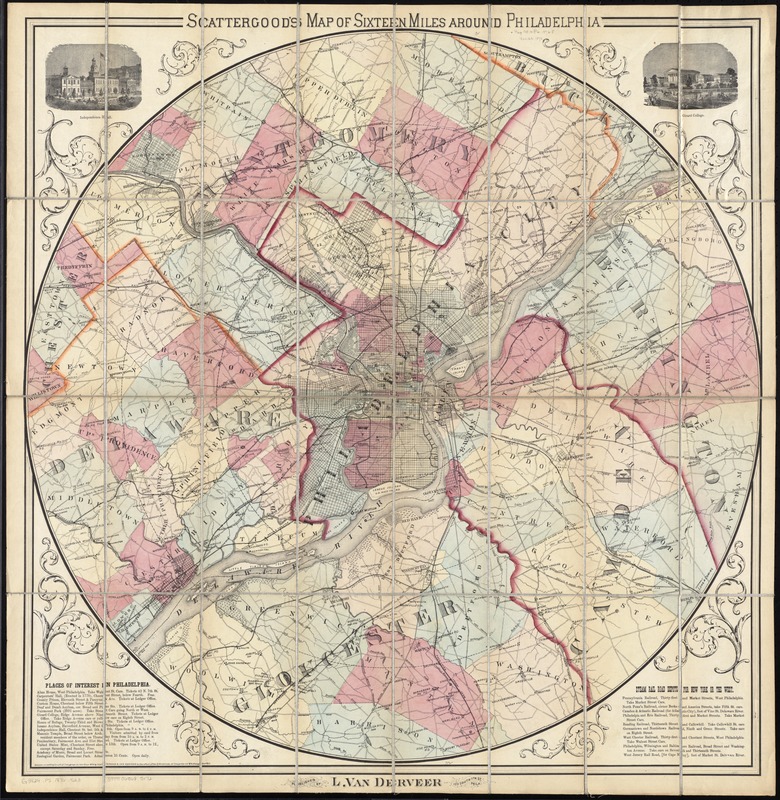
Scattergood's map of sixteen miles around Philadelphia
Item Information
- Title:
- Scattergood's map of sixteen miles around Philadelphia
- Title (alt.):
-
Map of sixteen miles around Philadelphia
- Creator:
- Scattergood & Van Derveer
- Date:
-
1876
- Format:
-
Maps/Atlases
- Location:
-
Boston Public Library
Norman B. Leventhal Map Center - Collection (local):
-
Norman B. Leventhal Map Center Collection
- Subjects:
-
Historic buildings--Pennsylvania--Philadelphia--Pictorial works
Philadelphia (Pa.)--Maps
- Places:
-
Philadelphia (county)Philadelphia
- Extent:
- 1 map : hand col. ; 85 x 84 cm.
- Terms of Use:
-
No known copyright restrictions.
No known restrictions on use.
- Publisher:
-
Philadelphia :
L. Van Derveer
- Scale:
-
Scale [ca. 1:61,600]
- Language:
-
English
- Notes:
-
Relief shown by hachures. Depths shown by soundings.
Shows townships, cities and towns, population, railroads, waterways, marshes and radial distances from Broad & Market Sts.
Includes ill. of Independence Hall and Girard Hall.
Includes text describing places of interest and steam rail road depots.
"Entered according to act of Congress in the Year 1876 by SCATTERGOOD & VAN DERVEER in the office of the Librarian of Congress at Washington, D.C."
- Identifier:
-
06_01_011489
- Call #:
-
G3824.P5 1876 .S23
- Barcode:
-
39999065685172