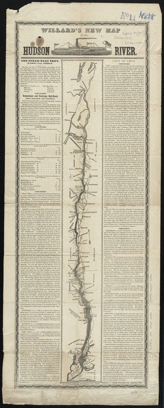
Willard's new map of the Hudson River
Item Information
- Title:
- Willard's new map of the Hudson River
- Title (alt.):
-
New map of the Hudson River
- Creator:
- Willard, Joseph.
- Date:
-
[1840?–1849?]
- Format:
-
Maps/Atlases
- Location:
-
Boston Public Library
Norman B. Leventhal Map Center - Collection (local):
-
Norman B. Leventhal Map Center Collection
- Subjects:
-
Hudson River (N.Y. and N.J.)--Maps
Hudson River Valley (N.Y. and N.J.)--Maps
- Places:
-
Hudson River
New York
- Extent:
- 1 map ; 63 x 8 cm., on sheet 78 x 31 cm.
- Terms of Use:
-
No known copyright restrictions.
No known restrictions on use.
- Publisher:
-
Troy :
Joseph Willard
- Scale:
-
Scale [ca. 1:600,000]
- Language:
-
English
- Notes:
-
Published as a broadside with map comprising the center column flanked by one column of text on each side.
Relief shown by hachures.
Includes descriptive text and distance tables.
- Identifier:
-
06_01_010660
- Call #:
-
G3802.H9 1840 .W55
- Barcode:
-
39999065675090


![[Willard's new map of the Hudson River for 1844]](https://bpldcassets.blob.core.windows.net/derivatives/images/commonwealth:b8516310f/image_thumbnail_300.jpg)
