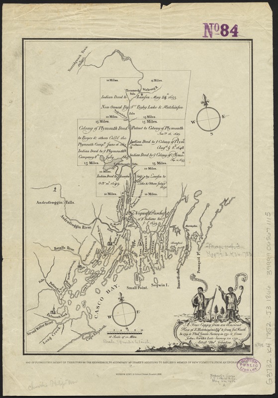
A true coppy from an ancient plan of E. Hutchinson's, Esqr. & from Jose. Heath in 1719 & Phins. Jones's survey in 1731 & from John North's late survey in 1752
Item Information
- Title:
- A true coppy from an ancient plan of E. Hutchinson's, Esqr. & from Jose. Heath in 1719 & Phins. Jones's survey in 1731 & from John North's late survey in 1752
- Title (alt.):
-
Map of Plymouth's patent of territory on the Kennebeck, to accompany Mr. Drake's additions to Baylies's memoir of New Plymouth, from an engraving 1753
- Creator:
- Johnston, Thomas, 1708-1767
- Name on Item:
-
attest Thos. Johnston.
- Date:
-
1866
- Format:
-
Maps/Atlases
- Location:
-
Boston Public Library
Norman B. Leventhal Map Center - Collection (local):
-
Norman B. Leventhal Map Center Collection
- Subjects:
-
Kennebec River Region (Me.)--Maps--Early works to 1800--Facsimiles
Casco Bay Region (Me.)--Maps--Early works to 1800--Facsimiles
Kennebec Patent (Me.)--Maps--Early works to 1800--Facsimiles
Massachusetts--History--New Plymouth, 1620-1691--Maps--Early works to 1800--Facsimiles
- Places:
-
Kennebec (river)
Plymouth (county)Plymouth
Kennebec (county)
Cumberland (county)Casco Bay
- Extent:
- 1 map ; 29 x 21 cm.
- Terms of Use:
-
No known copyright restrictions.
No known restrictions on use.
- Publisher:
-
Boston :
Wiggin & Lunt
- Scale:
-
Scale [ca. 1:500,000]
- Language:
-
English
- Notes:
-
Shows areas of land deeds.
Facsimile.
In lower margin: Map of Plymouth's patent of territory on the Kennebeck, to accompany Mr. Drake's additions to Baylies's memoir of New Plymouth from an engraving 1753.
From: Baylies' Historical memoir of the colony of New Plymouth. Vol. 2. p. 36.
Original: Boston : A. Trochsler & Co. Lith., [1753?].
- Identifier:
-
06_01_010420
- Call #:
-
G3732.K4 1752 .J3 1866
- Barcode:
-
39999065671115


