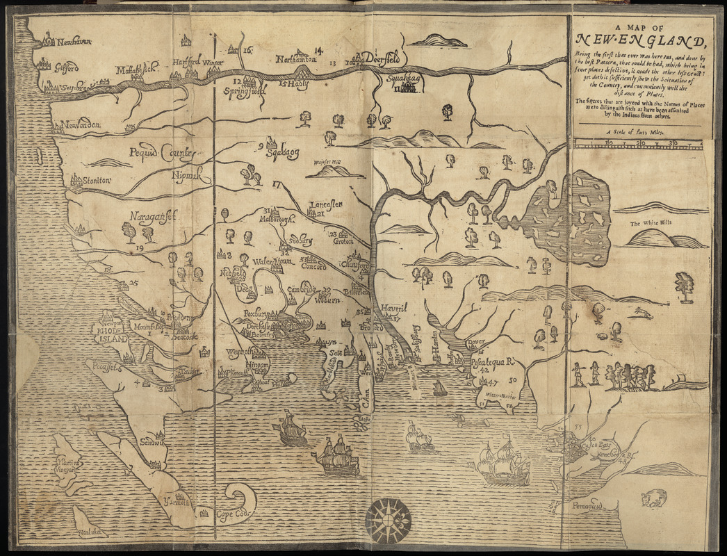
A map of New-England, being the first that ever was here cut, and done by the best pattern that could be had, which being in some places defective, it made the other less exact ; yet doth it sufficiently shew the scituation of the countrey, and conveniently well the distance of places
Item Information
- Title:
- A map of New-England, being the first that ever was here cut, and done by the best pattern that could be had, which being in some places defective, it made the other less exact ; yet doth it sufficiently shew the scituation of the countrey, and conveniently well the distance of places
- Description:
-
This map was the first to be printed in the British Colonies, and though crude in appearance was for its time the best available map of the region. Based on a 1665 survey by Bostonian William Reed, it was repurposed by Foster to illustrate William Hubbard’s Narrative of the Troubles with the Indians in New England. The Narrative described King Philip’s War of 1675-76, a horrific conflict between New England colonists and Algonquin Indians. By war’s end the native population had been decimated and dozens of colonial towns (shown numbered on this map) ravaged.
- Cartographer:
- Foster, John, 1648-1681
- Date:
-
[1677]
- Format:
-
Maps/Atlases
- Location:
-
Boston Public Library
Rare Books Department - Collection (local):
-
Special Collections, Rare Books
- Subjects:
-
New England--Maps--Early works to 1800
- Places:
-
New England (area)
- Extent:
- 1 map ; 31 x 39 cm.
- Terms of Use:
-
No known copyright restrictions.
No known restrictions on use.
- Scale:
-
Scale 1:90,000
- Language:
-
English
- Notes:
-
The "White hills" version of the map.
Probably engraved by: John Foster.
State 2 with additional town symbol between Seaconk and Plimouth.
In: Hubbard, William. A narrative of the troubles with the Indians. Boston. 1677.
- Notes (date):
-
This date is inferred.
- Notes (citation):
-
Wheat and Brun, 145
McCorkle, Barbara B. New England in Early Printed Maps, 677.2
- Notes (exhibitions):
-
Exhibited: "Made in Boston" organized by the Norman B. Leventhal Map Center at the Boston Public Library, 2013-2014.
- Identifier:
-
06_01_009269
- Call #:
-
BPL Rare Books Dept. G.365.62
- Barcode:
-
30000003857253


